![](/images/other/stat-length.png)
![Randonnée V.T.C. Sentheim - Courses ecolo - Photo](https://media.geolcdn.com/t/1900/400/2f1f4d83-3ab5-4961-8aae-0c8796839ca9.jpg&format=pjpeg&maxdim=2)
Courses ecolo
helmut68
Utilisateur
![Longueur](/images/other/stat-length.png)
Longueur
18,5 km
![Altitude max](https://static1.geolcdn.com/siteimages/upload/files/1508320355ic_sort_altitude_max_24dp.png)
Altitude max
366 m
![Dénivelé positif](https://static1.geolcdn.com/siteimages/upload/files/1508320355ic_sort_den_pos_24dp.png)
Dénivelé positif
124 m
![Km-Effort](/images/other/stat-length.png)
Km-Effort
20 km
![Altitude min](https://static1.geolcdn.com/siteimages/upload/files/1508320355ic_sort_altitude_min_24dp.png)
Altitude min
295 m
![Dénivelé négatif](https://static1.geolcdn.com/siteimages/upload/files/1508320355ic_sort_den_neg_24dp.png)
Dénivelé négatif
125 m
![Boucle](https://static1.geolcdn.com/siteimages/upload/files/16400158638029165_repeat_loop_refresh_sync_direction_icon.png)
Boucle
Oui
Date de création :
2020-01-04 10:27:44.499
Dernière modification :
2020-01-04 22:42:58.932
![V.T.C.](https://static1.geolcdn.com/sitytour/trail-icons/203.png)
1h02
Difficulté : Facile
![Scannez ce code QR pour ouvrir la randonnée dans l'application SityTrail](https://capi.geolives.com/qq0zvz2zws4bq2lad0pu/sitytour/trails/2297174/qr.png?size=200)
Application GPS de randonnée GRATUITE
À propos
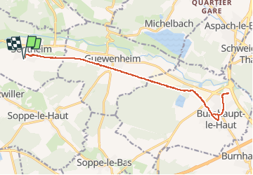
Randonnée V.T.C. de 18,5 km à découvrir à Grand Est, Haut-Rhin, Sentheim. Cette randonnée est proposée par helmut68.
Description
Faire ses petites courses en vélo c'est possible , agréable et écologique.
De Sentheim à Burnhaupt ou Masevaux nous disposons d'une belle piste cyclable alors profitons-en ...
Localisation
Pays :
France
Région :
Grand Est
Département/Province :
Haut-Rhin
Commune :
Sentheim
Localité :
Unknown
Départ:(Dec)
Départ:(UTM)
353878 ; 5290559 (32T) N.
Commentaires
Randonnées à proximité
![Randonnée Marche Masevaux-Niederbruck - Masevaux - Rossberg par le belvédère du Fuchsfelsen - Photo](https://media.geolcdn.com/t/375/260/d9cc765c-1250-4953-9d9f-fb8b88eb82a7.jpg&format=jpg&maxdim=2)
![Marche Marche](https://static1.geolcdn.com/sitytour/trail-icons/101.png)
Masevaux - Rossberg par le belvédère du Fuchsfelsen
Marche
Moyen
(1)
Masevaux-Niederbruck,
Grand Est,
Haut-Rhin,
France
![](/images/other/stat-length.png)
19,9 km | 34 km-effort
4h 44min
![](https://static1.geolcdn.com/siteimages/upload/files/16400158638029165_repeat_loop_refresh_sync_direction_icon.png)
Oui
![Randonnée Marche Sentheim - Sentheim Rossberg - Photo](https://media.geolcdn.com/t/375/260/a036ff16-f534-44a4-ad7d-39598edf8c1e.jpg&format=jpg&maxdim=2)
![Marche Marche](https://static1.geolcdn.com/sitytour/trail-icons/101.png)
Sentheim Rossberg
Marche
Moyen
(1)
Sentheim,
Grand Est,
Haut-Rhin,
France
![](/images/other/stat-length.png)
27 km | 40 km-effort
6h 11min
![](https://static1.geolcdn.com/siteimages/upload/files/16400158638029165_repeat_loop_refresh_sync_direction_icon.png)
Oui
![Randonnée Marche Lauw - 2022-07-14 Marche Lauw Refuge CAF Baerenkopf - Photo](https://media.geolcdn.com/t/375/260/e2209d17-65ac-46f6-a404-5274e10a843e.jpg&format=jpg&maxdim=2)
![Marche Marche](https://static1.geolcdn.com/sitytour/trail-icons/101.png)
2022-07-14 Marche Lauw Refuge CAF Baerenkopf
Marche
Très difficile
Lauw,
Grand Est,
Haut-Rhin,
France
![](/images/other/stat-length.png)
18,4 km | 31 km-effort
5h 35min
![](https://static1.geolcdn.com/siteimages/upload/files/16400158638029165_repeat_loop_refresh_sync_direction_icon.png)
Non
![Randonnée A pied Sentheim - Sentier géologique du Wolfloch - Photo](https://media.geolcdn.com/t/375/260/3b31644e-e98b-4e9b-958d-a3c4208c2bbd.jpeg&format=jpg&maxdim=2)
![A pied A pied](https://static1.geolcdn.com/sitytour/trail-icons/100.png)
Sentier géologique du Wolfloch
A pied
Facile
Sentheim,
Grand Est,
Haut-Rhin,
France
![](/images/other/stat-length.png)
3,8 km | 4,8 km-effort
1h 5min
![](https://static1.geolcdn.com/siteimages/upload/files/16400158638029165_repeat_loop_refresh_sync_direction_icon.png)
Non
![Randonnée A pied Sentheim - Sentheim - Bergwald - Eichwald - Guevenheim - Sentheim - Photo](https://media.geolcdn.com/t/375/260/ext.jpg?maxdim=2&url=https%3A%2F%2Fstatic1.geolcdn.com%2Fsiteimages%2Fupload%2Ffiles%2F1545311037marcheuse_200dpi.jpg)
![A pied A pied](https://static1.geolcdn.com/sitytour/trail-icons/100.png)
Sentheim - Bergwald - Eichwald - Guevenheim - Sentheim
A pied
Facile
(1)
Sentheim,
Grand Est,
Haut-Rhin,
France
![](/images/other/stat-length.png)
13,4 km | 16,6 km-effort
Inconnu
![](https://static1.geolcdn.com/siteimages/upload/files/16400158638029165_repeat_loop_refresh_sync_direction_icon.png)
Oui
![Randonnée Marche Masevaux-Niederbruck - Reco avec ALAIN..Rando CLAS du 29/08/2024 - Photo](https://media.geolcdn.com/t/375/260/5dba7985-af1b-4076-a275-05f9cb5145f8.jpg&format=jpg&maxdim=2)
![Marche Marche](https://static1.geolcdn.com/sitytour/trail-icons/101.png)
Reco avec ALAIN..Rando CLAS du 29/08/2024
Marche
Très difficile
Masevaux-Niederbruck,
Grand Est,
Haut-Rhin,
France
![](/images/other/stat-length.png)
20 km | 31 km-effort
6h 2min
![](https://static1.geolcdn.com/siteimages/upload/files/16400158638029165_repeat_loop_refresh_sync_direction_icon.png)
Oui
![Randonnée Marche Sentheim - Randonnée Pentecôte 2024 - Photo](https://media.geolcdn.com/t/375/260/5b01bebc-5c9b-4fee-93d4-97171ac59809.jpg&format=jpg&maxdim=2)
![Marche Marche](https://static1.geolcdn.com/sitytour/trail-icons/101.png)
Randonnée Pentecôte 2024
Marche
Moyen
Sentheim,
Grand Est,
Haut-Rhin,
France
![](/images/other/stat-length.png)
14,8 km | 18,3 km-effort
4h 0min
![](https://static1.geolcdn.com/siteimages/upload/files/16400158638029165_repeat_loop_refresh_sync_direction_icon.png)
Oui
![Randonnée Marche Sentheim - Knapphutte Saegenkopf Hütte - Photo](https://media.geolcdn.com/t/375/260/40c0149e-a232-4115-bfb0-15079675190f.jpg&format=jpg&maxdim=2)
![Marche Marche](https://static1.geolcdn.com/sitytour/trail-icons/101.png)
Knapphutte Saegenkopf Hütte
Marche
Moyen
Sentheim,
Grand Est,
Haut-Rhin,
France
![](/images/other/stat-length.png)
13,8 km | 17,2 km-effort
5h 11min
![](https://static1.geolcdn.com/siteimages/upload/files/16400158638029165_repeat_loop_refresh_sync_direction_icon.png)
Oui
![Randonnée Marche Sentheim - Montori - Photo](https://media.geolcdn.com/t/375/260/60fb76bf-d069-4a22-ad34-ce9de6b50bcf.jpg&format=jpg&maxdim=2)
![Marche Marche](https://static1.geolcdn.com/sitytour/trail-icons/101.png)