![](/images/other/stat-length.png)
![Randonnée Marche Champoléon - Borels (Champoléon) - Refuge du Tourond - Col de la Vénasque - Photo](https://media.geolcdn.com/t/1900/400/ext.pjpeg?maxdim=2&url=https%3A%2F%2Fstatic1.geolcdn.com%2Fsiteimages%2Fupload%2Ffiles%2F1553511878bg_sport_marche.png)
Borels (Champoléon) - Refuge du Tourond - Col de la Vénasque
gilbinrod
Utilisateur
![Longueur](/images/other/stat-length.png)
![Altitude max](https://static1.geolcdn.com/siteimages/upload/files/1508320355ic_sort_altitude_max_24dp.png)
![Dénivelé positif](https://static1.geolcdn.com/siteimages/upload/files/1508320355ic_sort_den_pos_24dp.png)
![Km-Effort](/images/other/stat-length.png)
![Altitude min](https://static1.geolcdn.com/siteimages/upload/files/1508320355ic_sort_altitude_min_24dp.png)
![Dénivelé négatif](https://static1.geolcdn.com/siteimages/upload/files/1508320355ic_sort_den_neg_24dp.png)
![Boucle](https://static1.geolcdn.com/siteimages/upload/files/16400158638029165_repeat_loop_refresh_sync_direction_icon.png)
![Marche](https://static1.geolcdn.com/sitytour/trail-icons/101.png)
8h20
Difficulté : Moyen
![Scannez ce code QR pour ouvrir la randonnée dans l'application SityTrail](https://capi.geolives.com/qq0zvz2zws4bq2lad0pu/sitytour/trails/205517/qr.png?size=200)
Application GPS de randonnée GRATUITE
À propos
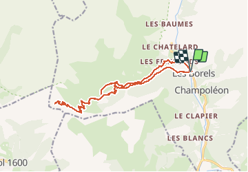
Randonnée Marche de 21 km à découvrir à Provence-Alpes-Côte d'Azur, Hautes-Alpes, Champoléon. Cette randonnée est proposée par gilbinrod.
Description
Une très belle randonnée : le magnifique cirque du Tourond, la montée rafraichissante dans le mélézin à l'ubac, le passage sur Planure, le paysage depuis le col. Montée l'après-midi au Refuge du Tourond la veille (petite visite à la cascade de la Pisse), avant d'attaquer la montée vers le col le lendemain, puis redescente des 1200m de dénivelé(visite en passant du haut de la cascade).
Localisation
Commentaires
Randonnées à proximité
![Randonnée Marche Orcières - Le Forest des marches - Photo](https://media.geolcdn.com/t/375/260/1bbb2305-7ec0-44b0-abf9-1e50226e1407.jpg&format=jpg&maxdim=2)
![Marche Marche](https://static1.geolcdn.com/sitytour/trail-icons/101.png)
Marche
![](/images/other/stat-length.png)
![](https://static1.geolcdn.com/siteimages/upload/files/16400158638029165_repeat_loop_refresh_sync_direction_icon.png)
![Randonnée Marche Champoléon - Lac de Prelles-Col du Cheval de bois - Photo](https://media.geolcdn.com/t/375/260/d8b66f59-3dd4-41c8-8493-8bdffe49ada9.jpg&format=jpg&maxdim=2)
![Marche Marche](https://static1.geolcdn.com/sitytour/trail-icons/101.png)
Marche
![](/images/other/stat-length.png)
![](https://static1.geolcdn.com/siteimages/upload/files/16400158638029165_repeat_loop_refresh_sync_direction_icon.png)
![Randonnée Marche Saint-Jean-Saint-Nicolas - Le Palastre - Photo](https://media.geolcdn.com/t/375/260/faa920e9-1ef8-4a51-8aab-abb18442e5b8.jpg&format=jpg&maxdim=2)
![Marche Marche](https://static1.geolcdn.com/sitytour/trail-icons/101.png)
Marche
![](/images/other/stat-length.png)
![](https://static1.geolcdn.com/siteimages/upload/files/16400158638029165_repeat_loop_refresh_sync_direction_icon.png)
![Randonnée A pied Champoléon - Refuge du Tourond - Photo](https://media.geolcdn.com/t/375/260/42cbf5d1-e48d-4896-9483-7cb6a380b211.jpg&format=jpg&maxdim=2)
![A pied A pied](https://static1.geolcdn.com/sitytour/trail-icons/100.png)
A pied
![](/images/other/stat-length.png)
![](https://static1.geolcdn.com/siteimages/upload/files/16400158638029165_repeat_loop_refresh_sync_direction_icon.png)
![Randonnée Marche Champoléon - Méollion - Photo](https://media.geolcdn.com/t/375/260/da24cc78-a99a-4fa8-9dce-d97d6d7f39a5.jpg&format=jpg&maxdim=2)
![Marche Marche](https://static1.geolcdn.com/sitytour/trail-icons/101.png)
Marche
![](/images/other/stat-length.png)
![](https://static1.geolcdn.com/siteimages/upload/files/16400158638029165_repeat_loop_refresh_sync_direction_icon.png)
![Marche Marche](https://static1.geolcdn.com/sitytour/trail-icons/101.png)
Marche
![](/images/other/stat-length.png)
![](https://static1.geolcdn.com/siteimages/upload/files/16400158638029165_repeat_loop_refresh_sync_direction_icon.png)
![Randonnée Marche Champoléon - Balade Vallée Champoléon - Photo](https://media.geolcdn.com/t/375/260/23c779ce-adcf-411d-9db1-4b3234bce8ff.jpg&format=jpg&maxdim=2)
![Marche Marche](https://static1.geolcdn.com/sitytour/trail-icons/101.png)
Marche
![](/images/other/stat-length.png)
![](https://static1.geolcdn.com/siteimages/upload/files/16400158638029165_repeat_loop_refresh_sync_direction_icon.png)
![Randonnée Ski de randonnée Saint-Jean-Saint-Nicolas - Soleil boeuf - Photo](https://media.geolcdn.com/t/375/260/845c7dbb-c2d0-4333-a1ea-f52a60db91cf.jpg&format=jpg&maxdim=2)
![Ski de randonnée Ski de randonnée](https://static1.geolcdn.com/sitytour/trail-icons/503.png)
Ski de randonnée
![](/images/other/stat-length.png)
![](https://static1.geolcdn.com/siteimages/upload/files/16400158638029165_repeat_loop_refresh_sync_direction_icon.png)
![Randonnée Ski de randonnée Saint-Jean-Saint-Nicolas - Soleil boeuf et petite remontée à Prouveyrat - Photo](https://media.geolcdn.com/t/375/260/24b9b2dd-138e-4875-9609-8a92cb5ef256.jpg&format=jpg&maxdim=2)
![Ski de randonnée Ski de randonnée](https://static1.geolcdn.com/sitytour/trail-icons/503.png)
Ski de randonnée
![](/images/other/stat-length.png)
![](https://static1.geolcdn.com/siteimages/upload/files/16400158638029165_repeat_loop_refresh_sync_direction_icon.png)