![](/images/other/stat-length.png)
![Randonnée Marche Champoléon - Méollion depuis les Borels - Photo](https://media.geolcdn.com/t/1900/400/ext.pjpeg?maxdim=2&url=https%3A%2F%2Fstatic1.geolcdn.com%2Fsiteimages%2Fupload%2Ffiles%2F1553511878bg_sport_marche.png)
Méollion depuis les Borels
gilbinrod
Utilisateur
![Longueur](/images/other/stat-length.png)
![Altitude max](https://static1.geolcdn.com/siteimages/upload/files/1508320355ic_sort_altitude_max_24dp.png)
![Dénivelé positif](https://static1.geolcdn.com/siteimages/upload/files/1508320355ic_sort_den_pos_24dp.png)
![Km-Effort](/images/other/stat-length.png)
![Altitude min](https://static1.geolcdn.com/siteimages/upload/files/1508320355ic_sort_altitude_min_24dp.png)
![Dénivelé négatif](https://static1.geolcdn.com/siteimages/upload/files/1508320355ic_sort_den_neg_24dp.png)
![Boucle](https://static1.geolcdn.com/siteimages/upload/files/16400158638029165_repeat_loop_refresh_sync_direction_icon.png)
![Marche](https://static1.geolcdn.com/sitytour/trail-icons/101.png)
6h45
Difficulté : Facile
![Scannez ce code QR pour ouvrir la randonnée dans l'application SityTrail](https://capi.geolives.com/qq0zvz2zws4bq2lad0pu/sitytour/trails/205497/qr.png?size=200)
Application GPS de randonnée GRATUITE
À propos
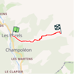
Randonnée Marche de 3,3 km à découvrir à Provence-Alpes-Côte d'Azur, Hautes-Alpes, Champoléon. Cette randonnée est proposée par gilbinrod.
Description
Le vallon de Méollion débouche sur la gauche de la vallée principale du Drac Blanc un peu en aval des Borels par un puissant cône de déjection qui a plaqué le Drac contre sa rive droite.
Depuis les Borels, le chemin autrefois carrossable et souvent ombragé passe successivement à Serre Borel (1300 m), Pied du Champet (1305 m), le Forest, lieu situé à l'extérieur ou éloigné en occitan alpin et non pas lieu forestier comme en français, Haut des Poas, autrement dit haut des montées (1630 m), et enfin Méollion, et sous, ou presque, les cascades de Méollion.
Localisation
Commentaires
Randonnées à proximité
![Randonnée Marche Orcières - Le Forest des marches - Photo](https://media.geolcdn.com/t/375/260/1bbb2305-7ec0-44b0-abf9-1e50226e1407.jpg&format=jpg&maxdim=2)
![Marche Marche](https://static1.geolcdn.com/sitytour/trail-icons/101.png)
Marche
![](/images/other/stat-length.png)
![](https://static1.geolcdn.com/siteimages/upload/files/16400158638029165_repeat_loop_refresh_sync_direction_icon.png)
![Randonnée Marche Champoléon - Lac de Prelles-Col du Cheval de bois - Photo](https://media.geolcdn.com/t/375/260/d8b66f59-3dd4-41c8-8493-8bdffe49ada9.jpg&format=jpg&maxdim=2)
![Marche Marche](https://static1.geolcdn.com/sitytour/trail-icons/101.png)
Marche
![](/images/other/stat-length.png)
![](https://static1.geolcdn.com/siteimages/upload/files/16400158638029165_repeat_loop_refresh_sync_direction_icon.png)
![Randonnée Marche Saint-Jean-Saint-Nicolas - Le Palastre - Photo](https://media.geolcdn.com/t/375/260/faa920e9-1ef8-4a51-8aab-abb18442e5b8.jpg&format=jpg&maxdim=2)
![Marche Marche](https://static1.geolcdn.com/sitytour/trail-icons/101.png)
Marche
![](/images/other/stat-length.png)
![](https://static1.geolcdn.com/siteimages/upload/files/16400158638029165_repeat_loop_refresh_sync_direction_icon.png)
![Randonnée A pied Champoléon - Refuge du Tourond - Photo](https://media.geolcdn.com/t/375/260/42cbf5d1-e48d-4896-9483-7cb6a380b211.jpg&format=jpg&maxdim=2)
![A pied A pied](https://static1.geolcdn.com/sitytour/trail-icons/100.png)
A pied
![](/images/other/stat-length.png)
![](https://static1.geolcdn.com/siteimages/upload/files/16400158638029165_repeat_loop_refresh_sync_direction_icon.png)
![Randonnée Marche Champoléon - Méollion - Photo](https://media.geolcdn.com/t/375/260/da24cc78-a99a-4fa8-9dce-d97d6d7f39a5.jpg&format=jpg&maxdim=2)
![Marche Marche](https://static1.geolcdn.com/sitytour/trail-icons/101.png)
Marche
![](/images/other/stat-length.png)
![](https://static1.geolcdn.com/siteimages/upload/files/16400158638029165_repeat_loop_refresh_sync_direction_icon.png)
![Marche Marche](https://static1.geolcdn.com/sitytour/trail-icons/101.png)
Marche
![](/images/other/stat-length.png)
![](https://static1.geolcdn.com/siteimages/upload/files/16400158638029165_repeat_loop_refresh_sync_direction_icon.png)
![Randonnée Marche Champoléon - Balade Vallée Champoléon - Photo](https://media.geolcdn.com/t/375/260/23c779ce-adcf-411d-9db1-4b3234bce8ff.jpg&format=jpg&maxdim=2)
![Marche Marche](https://static1.geolcdn.com/sitytour/trail-icons/101.png)
Marche
![](/images/other/stat-length.png)
![](https://static1.geolcdn.com/siteimages/upload/files/16400158638029165_repeat_loop_refresh_sync_direction_icon.png)
![Randonnée Ski de randonnée Saint-Jean-Saint-Nicolas - Soleil boeuf - Photo](https://media.geolcdn.com/t/375/260/845c7dbb-c2d0-4333-a1ea-f52a60db91cf.jpg&format=jpg&maxdim=2)
![Ski de randonnée Ski de randonnée](https://static1.geolcdn.com/sitytour/trail-icons/503.png)
Ski de randonnée
![](/images/other/stat-length.png)
![](https://static1.geolcdn.com/siteimages/upload/files/16400158638029165_repeat_loop_refresh_sync_direction_icon.png)
![Randonnée Ski de randonnée Saint-Jean-Saint-Nicolas - Soleil boeuf et petite remontée à Prouveyrat - Photo](https://media.geolcdn.com/t/375/260/24b9b2dd-138e-4875-9609-8a92cb5ef256.jpg&format=jpg&maxdim=2)
![Ski de randonnée Ski de randonnée](https://static1.geolcdn.com/sitytour/trail-icons/503.png)
Ski de randonnée
![](/images/other/stat-length.png)
![](https://static1.geolcdn.com/siteimages/upload/files/16400158638029165_repeat_loop_refresh_sync_direction_icon.png)