![](/images/other/stat-length.png)
![Randonnée Marche Saint-Paul-sur-Ubaye - Tour du Plan de Parouart - Photo](https://media.geolcdn.com/t/1900/400/ext.pjpeg?maxdim=2&url=https%3A%2F%2Fstatic1.geolcdn.com%2Fsiteimages%2Fupload%2Ffiles%2F1553511878bg_sport_marche.png)
Tour du Plan de Parouart
yoyolyon
Utilisateur
![Longueur](/images/other/stat-length.png)
Longueur
11,7 km
![Altitude max](https://static1.geolcdn.com/siteimages/upload/files/1508320355ic_sort_altitude_max_24dp.png)
Altitude max
2103 m
![Dénivelé positif](https://static1.geolcdn.com/siteimages/upload/files/1508320355ic_sort_den_pos_24dp.png)
Dénivelé positif
295 m
![Km-Effort](/images/other/stat-length.png)
Km-Effort
15,7 km
![Altitude min](https://static1.geolcdn.com/siteimages/upload/files/1508320355ic_sort_altitude_min_24dp.png)
Altitude min
1902 m
![Dénivelé négatif](https://static1.geolcdn.com/siteimages/upload/files/1508320355ic_sort_den_neg_24dp.png)
Dénivelé négatif
300 m
![Boucle](https://static1.geolcdn.com/siteimages/upload/files/16400158638029165_repeat_loop_refresh_sync_direction_icon.png)
Boucle
Non
Date de création :
2014-12-10 00:00:00.0
Dernière modification :
2014-12-10 00:00:00.0
![Marche](https://static1.geolcdn.com/sitytour/trail-icons/101.png)
3h46
Difficulté : Inconnu
![Scannez ce code QR pour ouvrir la randonnée dans l'application SityTrail](https://capi.geolives.com/qq0zvz2zws4bq2lad0pu/sitytour/trails/149283/qr.png?size=200)
Application GPS de randonnée GRATUITE
À propos
Randonnée Marche de 11,7 km à découvrir à Provence-Alpes-Côte d'Azur, Alpes-de-Haute-Provence, Saint-Paul-sur-Ubaye. Cette randonnée est proposée par yoyolyon.
Description
Le lac de Parouart créé par un énorme éboulement venu barrer la vallée, s'est comblé il y 50 ans environ. Il reste aujourd'hui une étrange plaine humide où coule, sans bruit, une Ubaye tranquille.
Localisation
Pays :
France
Région :
Provence-Alpes-Côte d'Azur
Département/Province :
Alpes-de-Haute-Provence
Commune :
Saint-Paul-sur-Ubaye
Localité :
Unknown
Départ:(Dec)
Départ:(UTM)
328890 ; 4940075 (32T) N.
Commentaires
Randonnées à proximité
![Randonnée Marche Saint-Paul-sur-Ubaye - 05 Tour Font Sancte - étape 3 - Photo](https://media.geolcdn.com/t/375/260/ext.jpg?maxdim=2&url=https%3A%2F%2Fstatic1.geolcdn.com%2Fsiteimages%2Fupload%2Ffiles%2F1553511878bg_sport_marche.png)
![Marche Marche](https://static1.geolcdn.com/sitytour/trail-icons/101.png)
05 Tour Font Sancte - étape 3
Marche
Très difficile
(1)
Saint-Paul-sur-Ubaye,
Provence-Alpes-Côte d'Azur,
Alpes-de-Haute-Provence,
France
![](/images/other/stat-length.png)
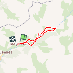
16,7 km | 31 km-effort
7h 8min
![](https://static1.geolcdn.com/siteimages/upload/files/16400158638029165_repeat_loop_refresh_sync_direction_icon.png)
Non
![Randonnée Autre activité Ceillac - Col de la petite Par. Col Girardin - Photo](https://media.geolcdn.com/t/375/260/ext.jpg?maxdim=2&url=https%3A%2F%2Fservices.sitytrail.com%2FGeolivesWS%2FDownloadMedia.ashx%3FTrailID%3D580882%26Media%3Dfix__20160521101555.jpg)
![Autre activité Autre activité](https://static1.geolcdn.com/sitytour/trail-icons/900.png)
Col de la petite Par. Col Girardin
Autre activité
Difficile
Ceillac,
Provence-Alpes-Côte d'Azur,
Hautes-Alpes,
France
![](/images/other/stat-length.png)
13,9 km | 32 km-effort
7h 36min
![](https://static1.geolcdn.com/siteimages/upload/files/16400158638029165_repeat_loop_refresh_sync_direction_icon.png)
Oui
![Randonnée Marche Saint-Paul-sur-Ubaye - Pic Panestrel - Photo](https://media.geolcdn.com/t/375/260/ext.jpg?maxdim=2&url=https%3A%2F%2Fstatic1.geolcdn.com%2Fsiteimages%2Fupload%2Ffiles%2F1553511878bg_sport_marche.png)
![Marche Marche](https://static1.geolcdn.com/sitytour/trail-icons/101.png)
Pic Panestrel
Marche
Difficile
(1)
Saint-Paul-sur-Ubaye,
Provence-Alpes-Côte d'Azur,
Alpes-de-Haute-Provence,
France
![](/images/other/stat-length.png)
13 km | 32 km-effort
6h 16min
![](https://static1.geolcdn.com/siteimages/upload/files/16400158638029165_repeat_loop_refresh_sync_direction_icon.png)
Oui
![Randonnée Marche Ceillac - Lac Ste Anne et Tête de Girardin - Photo](https://media.geolcdn.com/t/375/260/ext.jpg?maxdim=2&url=https%3A%2F%2Fservices.sitytrail.com%2FGeolivesWS%2FDownloadMedia.ashx%3FTrailID%3D324938%26Media%3Dfix__20140716140038.jpg)
![Marche Marche](https://static1.geolcdn.com/sitytour/trail-icons/101.png)
Lac Ste Anne et Tête de Girardin
Marche
Moyen
Ceillac,
Provence-Alpes-Côte d'Azur,
Hautes-Alpes,
France
![](/images/other/stat-length.png)
14,4 km | 27 km-effort
5h 48min
![](https://static1.geolcdn.com/siteimages/upload/files/16400158638029165_repeat_loop_refresh_sync_direction_icon.png)
Oui
![Randonnée Marche Ceillac - lac Sainte Anne - Photo](https://media.geolcdn.com/t/375/260/ext.jpg?maxdim=2&url=https%3A%2F%2Fstatic1.geolcdn.com%2Fsiteimages%2Fupload%2Ffiles%2F1553511878bg_sport_marche.png)
![Marche Marche](https://static1.geolcdn.com/sitytour/trail-icons/101.png)
lac Sainte Anne
Marche
Facile
(2)
Ceillac,
Provence-Alpes-Côte d'Azur,
Hautes-Alpes,
France
![](/images/other/stat-length.png)
10,7 km | 17,9 km-effort
5h 16min
![](https://static1.geolcdn.com/siteimages/upload/files/16400158638029165_repeat_loop_refresh_sync_direction_icon.png)
Non
![Randonnée Marche Ceillac - cols Tronchet et Girardin - Photo](https://media.geolcdn.com/t/375/260/cf0dc948-d683-46aa-82d1-7de4f0ef6cd8.jpg&format=jpg&maxdim=2)
![Marche Marche](https://static1.geolcdn.com/sitytour/trail-icons/101.png)
cols Tronchet et Girardin
Marche
Moyen
Ceillac,
Provence-Alpes-Côte d'Azur,
Hautes-Alpes,
France
![](/images/other/stat-length.png)
13,8 km | 27 km-effort
7h 56min
![](https://static1.geolcdn.com/siteimages/upload/files/16400158638029165_repeat_loop_refresh_sync_direction_icon.png)
Oui
![Randonnée Raquettes à neige Ceillac - ceillac ste Anne lac mirroir 11kms 486m - Photo](https://media.geolcdn.com/t/375/260/bc759666-5776-496b-bc02-3e54abf80af8.jpg&format=jpg&maxdim=2)
![Raquettes à neige Raquettes à neige](https://static1.geolcdn.com/sitytour/trail-icons/504.png)
ceillac ste Anne lac mirroir 11kms 486m
Raquettes à neige
Moyen
Ceillac,
Provence-Alpes-Côte d'Azur,
Hautes-Alpes,
France
![](/images/other/stat-length.png)
9,7 km | 16,5 km-effort
6h 57min
![](https://static1.geolcdn.com/siteimages/upload/files/16400158638029165_repeat_loop_refresh_sync_direction_icon.png)
Non
![Randonnée Marche Saint-Paul-sur-Ubaye - Col des Houerts - Photo](https://media.geolcdn.com/t/375/260/e589d054-4f9a-4316-9b77-f2f1a1c65f56.jpg&format=jpg&maxdim=2)
![Marche Marche](https://static1.geolcdn.com/sitytour/trail-icons/101.png)
Col des Houerts
Marche
Moyen
Saint-Paul-sur-Ubaye,
Provence-Alpes-Côte d'Azur,
Alpes-de-Haute-Provence,
France
![](/images/other/stat-length.png)
14,1 km | 32 km-effort
6h 36min
![](https://static1.geolcdn.com/siteimages/upload/files/16400158638029165_repeat_loop_refresh_sync_direction_icon.png)
Oui
![Randonnée Marche Ceillac - lac Saint Anne et Miroir - Photo](https://media.geolcdn.com/t/375/260/499baab9-73ff-429d-bc72-419d65f120e0.jpg&format=jpg&maxdim=2)
![Marche Marche](https://static1.geolcdn.com/sitytour/trail-icons/101.png)
lac Saint Anne et Miroir
Marche
Moyen
Ceillac,
Provence-Alpes-Côte d'Azur,
Hautes-Alpes,
France
![](/images/other/stat-length.png)
10,9 km | 18,5 km-effort
4h 14min
![](https://static1.geolcdn.com/siteimages/upload/files/16400158638029165_repeat_loop_refresh_sync_direction_icon.png)
Oui