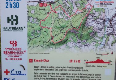
![](/images/other/stat-length.png)
![Randonnée Marche Oloron-Sainte-Marie - Sentier karstique - Piémont Oloronais - Photo](https://media.geolcdn.com/t/1900/400/ext.pjpeg?maxdim=2&url=https%3A%2F%2Fservices.sitytrail.com%2FGeolivesWS%2FDownloadMedia.ashx%3FTrailID%3D111311%26Media%3D6977_1.jpg)
Sentier karstique - Piémont Oloronais
tracegps
Utilisateur
![Longueur](/images/other/stat-length.png)
![Altitude max](https://static1.geolcdn.com/siteimages/upload/files/1508320355ic_sort_altitude_max_24dp.png)
![Dénivelé positif](https://static1.geolcdn.com/siteimages/upload/files/1508320355ic_sort_den_pos_24dp.png)
![Km-Effort](/images/other/stat-length.png)
![Altitude min](https://static1.geolcdn.com/siteimages/upload/files/1508320355ic_sort_altitude_min_24dp.png)
![Dénivelé négatif](https://static1.geolcdn.com/siteimages/upload/files/1508320355ic_sort_den_neg_24dp.png)
![Boucle](https://static1.geolcdn.com/siteimages/upload/files/16400158638029165_repeat_loop_refresh_sync_direction_icon.png)
![Marche](https://static1.geolcdn.com/sitytour/trail-icons/101.png)
1h00
Difficulté : Facile
![Scannez ce code QR pour ouvrir la randonnée dans l'application SityTrail](https://capi.geolives.com/qq0zvz2zws4bq2lad0pu/sitytour/trails/111311/qr.png?size=200)
Application GPS de randonnée GRATUITE
À propos
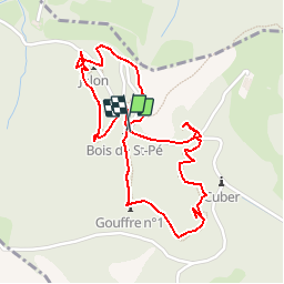
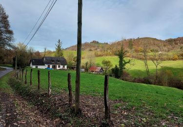
Randonnée Marche de 2,7 km à découvrir à Nouvelle-Aquitaine, Pyrénées-Atlantiques, Oloron-Sainte-Marie. Cette randonnée est proposée par tracegps.
Description
Unique en son genre et spectaculaire, cet itinéraire qui va de gouffre en gouffre est une porte ouverte sur le monde souterrain. Sur un sentier forestier et par des passerelles au-dessus des grottes, vous découvrirez, le temps d´une balade familiale,l´immense et insoupçonnable réseau de cavités ouvertes sous nos pieds. Retrouvez d’autres informations et la fiche descriptive sur le site Pays Basque et Béarn.
Localisation
Commentaires
Randonnées à proximité
![Randonnée Course à pied Oloron-Sainte-Marie - OLORON Le camp de Cesar G4](https://media.geolcdn.com/t/375/260/e472b0d2-5d8f-43de-b167-1446063f7ed6.jpg&format=jpg&maxdim=2)
![Course à pied Course à pied](https://static1.geolcdn.com/sitytour/trail-icons/103.png)
Course à pied
![](/images/other/stat-length.png)
![](https://static1.geolcdn.com/siteimages/upload/files/16400158638029165_repeat_loop_refresh_sync_direction_icon.png)
![Randonnée A pied Oloron-Sainte-Marie - OLORON / LURBE - SAINT CHRISTAUD balisage GR 653 balisage - Photo](https://media.geolcdn.com/t/375/260/3e9828ef-bc7b-413a-8d74-e856dfe267ad.jpg&format=jpg&maxdim=2)
![A pied A pied](https://static1.geolcdn.com/sitytour/trail-icons/100.png)
A pied
![](/images/other/stat-length.png)
![](https://static1.geolcdn.com/siteimages/upload/files/16400158638029165_repeat_loop_refresh_sync_direction_icon.png)
![Randonnée Marche Ance-Féas - Ance Unars G3 2021 - Photo](https://media.geolcdn.com/t/375/260/5484398e-627e-4050-b331-9b372303d130.jpg&format=jpg&maxdim=2)
![Marche Marche](https://static1.geolcdn.com/sitytour/trail-icons/101.png)
Marche
![](/images/other/stat-length.png)
![](https://static1.geolcdn.com/siteimages/upload/files/16400158638029165_repeat_loop_refresh_sync_direction_icon.png)
![Randonnée Marche Oloron-Sainte-Marie - G4 Haut doloron - Photo](https://media.geolcdn.com/t/375/260/62971c8b-edeb-4f82-8ed6-042d0d814008.jpg&format=jpg&maxdim=2)
![Marche Marche](https://static1.geolcdn.com/sitytour/trail-icons/101.png)
Marche
![](/images/other/stat-length.png)
![](https://static1.geolcdn.com/siteimages/upload/files/16400158638029165_repeat_loop_refresh_sync_direction_icon.png)
![Randonnée A pied Oloron-Sainte-Marie - OLORON Le camp de Cesar](https://media.geolcdn.com/t/375/260/ext.jpg?maxdim=2&url=https%3A%2F%2Fstatic1.geolcdn.com%2Fsiteimages%2Fupload%2Ffiles%2F1545311037marcheuse_200dpi.jpg)
![A pied A pied](https://static1.geolcdn.com/sitytour/trail-icons/100.png)
A pied
![](/images/other/stat-length.png)
![](https://static1.geolcdn.com/siteimages/upload/files/16400158638029165_repeat_loop_refresh_sync_direction_icon.png)
![Randonnée Marche Oloron-Sainte-Marie - Chemin du Piémont Pyrénéen - De Oloron Sainte Marie à L'Hopital St Blaise - Photo](https://media.geolcdn.com/t/375/260/ext.jpg?maxdim=2&url=https%3A%2F%2Fservices.sitytrail.com%2FGeolivesWS%2FDownloadMedia.ashx%3FTrailID%3D111318%26Media%3D6991_1.jpg)
![Marche Marche](https://static1.geolcdn.com/sitytour/trail-icons/101.png)
Marche
![](/images/other/stat-length.png)
![](https://static1.geolcdn.com/siteimages/upload/files/16400158638029165_repeat_loop_refresh_sync_direction_icon.png)
![Randonnée Marche Oloron-Sainte-Marie - test OLORON versée dans TIAGO - Photo](https://media.geolcdn.com/t/375/260/ext.jpg?maxdim=2&url=https%3A%2F%2Fstatic1.geolcdn.com%2Fsiteimages%2Fupload%2Ffiles%2F1553511878bg_sport_marche.png)
![Marche Marche](https://static1.geolcdn.com/sitytour/trail-icons/101.png)
Marche
![](/images/other/stat-length.png)
![](https://static1.geolcdn.com/siteimages/upload/files/16400158638029165_repeat_loop_refresh_sync_direction_icon.png)
![Randonnée Marche Oloron-Sainte-Marie - Pyrenees-Atl - Oloron-Ste-Marie St-Pee-d-en-Bas Col de Sabareil 19km 451m - Photo](https://media.geolcdn.com/t/375/260/ext.jpg?maxdim=2&url=https%3A%2F%2Fstatic1.geolcdn.com%2Fsiteimages%2Fupload%2Ffiles%2F1553511878bg_sport_marche.png)
![Marche Marche](https://static1.geolcdn.com/sitytour/trail-icons/101.png)
Marche
![](/images/other/stat-length.png)
![](https://static1.geolcdn.com/siteimages/upload/files/16400158638029165_repeat_loop_refresh_sync_direction_icon.png)
![Randonnée Marche Esquiule - G3-ESQUIULE-Sommet de Cambilhou TC - Photo](https://media.geolcdn.com/t/375/260/16eaa28c-6eac-4938-b1a8-3a1bd300a597.jpg&format=jpg&maxdim=2)
![Marche Marche](https://static1.geolcdn.com/sitytour/trail-icons/101.png)
Marche
![](/images/other/stat-length.png)
![](https://static1.geolcdn.com/siteimages/upload/files/16400158638029165_repeat_loop_refresh_sync_direction_icon.png)