![](/images/other/stat-length.png)
![Randonnée Marche Livinhac-le-Haut - Livinhac le Haut - Figeac - Chemin de St-Jacques de Compostelle - Photo](https://media.geolcdn.com/t/1900/400/ext.pjpeg?maxdim=2&url=https%3A%2F%2Fservices.sitytrail.com%2FGeolivesWS%2FDownloadMedia.ashx%3FTrailID%3D108748%26Media%3D1843_2.jpg)
Livinhac le Haut - Figeac - Chemin de St-Jacques de Compostelle
tracegps
Utilisateur
![Longueur](/images/other/stat-length.png)
Longueur
26 km
![Altitude max](https://static1.geolcdn.com/siteimages/upload/files/1508320355ic_sort_altitude_max_24dp.png)
Altitude max
417 m
![Dénivelé positif](https://static1.geolcdn.com/siteimages/upload/files/1508320355ic_sort_den_pos_24dp.png)
Dénivelé positif
584 m
![Km-Effort](/images/other/stat-length.png)
Km-Effort
33 km
![Altitude min](https://static1.geolcdn.com/siteimages/upload/files/1508320355ic_sort_altitude_min_24dp.png)
Altitude min
191 m
![Dénivelé négatif](https://static1.geolcdn.com/siteimages/upload/files/1508320355ic_sort_den_neg_24dp.png)
Dénivelé négatif
587 m
![Boucle](https://static1.geolcdn.com/siteimages/upload/files/16400158638029165_repeat_loop_refresh_sync_direction_icon.png)
Boucle
Non
Date de création :
2014-12-10 00:00:00.0
Dernière modification :
2014-12-10 00:00:00.0
![Marche](https://static1.geolcdn.com/sitytour/trail-icons/101.png)
5h00
Difficulté : Très difficile
![Scannez ce code QR pour ouvrir la randonnée dans l'application SityTrail](https://capi.geolives.com/qq0zvz2zws4bq2lad0pu/sitytour/trails/108748/qr.png?size=200)
Application GPS de randonnée GRATUITE
À propos
Randonnée Marche de 26 km à découvrir à Occitanie, Aveyron, Livinhac-le-Haut. Cette randonnée est proposée par tracegps.
Description
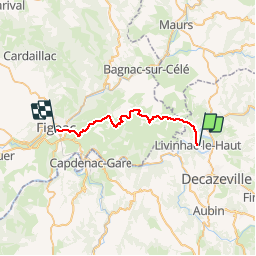
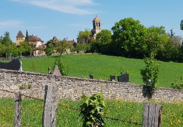
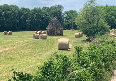
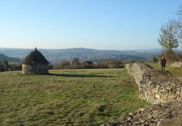
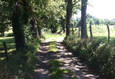
Douzième étape sur notre Chemin de Compostelle qui nous mène de Livinhac le Haut à Figeac. (Km 230,75 à Km 256,380) D’autres informations et photos sur le Chemin de Compostelle sont disponibles ICI Balade proposée par « Les Balades et Randonnées de Fred »
Localisation
Pays :
France
Région :
Occitanie
Département/Province :
Aveyron
Commune :
Livinhac-le-Haut
Localité :
Unknown
Départ:(Dec)
Départ:(UTM)
438978 ; 4937857 (31T) N.
Commentaires
Randonnées à proximité
![Randonnée Autre activité Decazeville - compostelle 2017 mt - Photo](https://media.geolcdn.com/t/375/260/ext.jpg?maxdim=2&url=https%3A%2F%2Fstatic1.geolcdn.com%2Fsiteimages%2Fupload%2Ffiles%2F1545311037marcheuse_200dpi.jpg)
![Autre activité Autre activité](https://static1.geolcdn.com/sitytour/trail-icons/900.png)
compostelle 2017 mt
Autre activité
Très facile
(5)
Decazeville,
Occitanie,
Aveyron,
France
![](/images/other/stat-length.png)
214 km | 295 km-effort
1666h 40min
![](https://static1.geolcdn.com/siteimages/upload/files/16400158638029165_repeat_loop_refresh_sync_direction_icon.png)
Non
![Randonnée A pied Decazeville - Les découvertes - Photo](https://media.geolcdn.com/t/375/260/dbdb4e7f-cbdd-4117-b74f-a3bed6296852.jpeg&format=jpg&maxdim=2)
![A pied A pied](https://static1.geolcdn.com/sitytour/trail-icons/100.png)
Les découvertes
A pied
Facile
Decazeville,
Occitanie,
Aveyron,
France
![](/images/other/stat-length.png)
12,3 km | 18,3 km-effort
4h 9min
![](https://static1.geolcdn.com/siteimages/upload/files/16400158638029165_repeat_loop_refresh_sync_direction_icon.png)
Non
![Randonnée A pied Decazeville - Entre plateau et découverte - Photo](https://media.geolcdn.com/t/375/260/482e8e3a-161f-4109-bd88-0e5ccb5b5287.jpeg&format=jpg&maxdim=2)
![A pied A pied](https://static1.geolcdn.com/sitytour/trail-icons/100.png)
Entre plateau et découverte
A pied
Facile
Decazeville,
Occitanie,
Aveyron,
France
![](/images/other/stat-length.png)
11,6 km | 17,1 km-effort
3h 53min
![](https://static1.geolcdn.com/siteimages/upload/files/16400158638029165_repeat_loop_refresh_sync_direction_icon.png)
Oui
![Randonnée A pied Decazeville - Le panoramique - Photo](https://media.geolcdn.com/t/375/260/2922232d-a6ec-4323-81bd-6511998b3c56.jpeg&format=jpg&maxdim=2)
![A pied A pied](https://static1.geolcdn.com/sitytour/trail-icons/100.png)
Le panoramique
A pied
Facile
Decazeville,
Occitanie,
Aveyron,
France
![](/images/other/stat-length.png)
4,3 km | 6,8 km-effort
1h 32min
![](https://static1.geolcdn.com/siteimages/upload/files/16400158638029165_repeat_loop_refresh_sync_direction_icon.png)
Oui
![Randonnée Marche Livinhac-le-Haut - Levinhac le Haut Figeac Avril 2018 - Photo](https://media.geolcdn.com/t/375/260/ext.jpg?maxdim=2&url=https%3A%2F%2Fservices.sitytrail.com%2FGeolivesWS%2FDownloadMedia.ashx%3FTrailID%3D955001%26Media%3Dfix__20180427114152.jpg)
![Marche Marche](https://static1.geolcdn.com/sitytour/trail-icons/101.png)
Levinhac le Haut Figeac Avril 2018
Marche
Moyen
Livinhac-le-Haut,
Occitanie,
Aveyron,
France
![](/images/other/stat-length.png)
24 km | 31 km-effort
6h 27min
![](https://static1.geolcdn.com/siteimages/upload/files/16400158638029165_repeat_loop_refresh_sync_direction_icon.png)
Non
![Randonnée Marche Livinhac-le-Haut - Compostelle 12 - Livinhac-le-haut -> Figeac - Photo](https://media.geolcdn.com/t/375/260/ext.jpg?maxdim=2&url=https%3A%2F%2Fstatic1.geolcdn.com%2Fsiteimages%2Fupload%2Ffiles%2F1553511878bg_sport_marche.png)
![Marche Marche](https://static1.geolcdn.com/sitytour/trail-icons/101.png)
Compostelle 12 - Livinhac-le-haut -> Figeac
Marche
Moyen
(1)
Livinhac-le-Haut,
Occitanie,
Aveyron,
France
![](/images/other/stat-length.png)
26 km | 33 km-effort
7h 4min
![](https://static1.geolcdn.com/siteimages/upload/files/16400158638029165_repeat_loop_refresh_sync_direction_icon.png)
Non
![Randonnée Marche Decazeville - Étape 12 Decazeville a Figeac - Photo](https://media.geolcdn.com/t/375/260/1d5991b7-38d4-43f6-8955-f1edda766907.jpg&format=jpg&maxdim=2)
![Marche Marche](https://static1.geolcdn.com/sitytour/trail-icons/101.png)
Étape 12 Decazeville a Figeac
Marche
Moyen
Decazeville,
Occitanie,
Aveyron,
France
![](/images/other/stat-length.png)
29 km | 38 km-effort
6h 27min
![](https://static1.geolcdn.com/siteimages/upload/files/16400158638029165_repeat_loop_refresh_sync_direction_icon.png)
Non
![Marche Marche](https://static1.geolcdn.com/sitytour/trail-icons/101.png)
CC_Velay_CB_11_Livinhac-Haut_Figeac_20071102
Marche
Moyen
Livinhac-le-Haut,
Occitanie,
Aveyron,
France
![](/images/other/stat-length.png)
26 km | 34 km-effort
6h 40min
![](https://static1.geolcdn.com/siteimages/upload/files/16400158638029165_repeat_loop_refresh_sync_direction_icon.png)
Non
![Randonnée Marche Livinhac-le-Haut - Livinhac le Haut vers Figeac - Photo](https://media.geolcdn.com/t/375/260/ext.jpg?maxdim=2&url=https%3A%2F%2Fservices.sitytrail.com%2FGeolivesWS%2FDownloadMedia.ashx%3FTrailID%3D814887%26Media%3D20170820114814.jpg)
![Marche Marche](https://static1.geolcdn.com/sitytour/trail-icons/101.png)
Livinhac le Haut vers Figeac
Marche
Moyen
Livinhac-le-Haut,
Occitanie,
Aveyron,
France
![](/images/other/stat-length.png)
25 km | 32 km-effort
6h 1min
![](https://static1.geolcdn.com/siteimages/upload/files/16400158638029165_repeat_loop_refresh_sync_direction_icon.png)
Non
bien