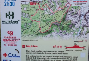
![](/images/other/stat-length.png)
![Randonnée Marche Oloron-Sainte-Marie - Chemin d'Arles à Compostelle - Oloron Ste Marie - Sarrance - Photo](https://media.geolcdn.com/t/1900/400/ext.pjpeg?maxdim=2&url=https%3A%2F%2Fservices.sitytrail.com%2FGeolivesWS%2FDownloadMedia.ashx%3FTrailID%3D105160%26Media%3D8787_1.jpg)
Chemin d'Arles à Compostelle - Oloron Ste Marie - Sarrance
tracegps
Utilisateur
![Longueur](/images/other/stat-length.png)
![Altitude max](https://static1.geolcdn.com/siteimages/upload/files/1508320355ic_sort_altitude_max_24dp.png)
![Dénivelé positif](https://static1.geolcdn.com/siteimages/upload/files/1508320355ic_sort_den_pos_24dp.png)
![Km-Effort](/images/other/stat-length.png)
![Altitude min](https://static1.geolcdn.com/siteimages/upload/files/1508320355ic_sort_altitude_min_24dp.png)
![Dénivelé négatif](https://static1.geolcdn.com/siteimages/upload/files/1508320355ic_sort_den_neg_24dp.png)
![Boucle](https://static1.geolcdn.com/siteimages/upload/files/16400158638029165_repeat_loop_refresh_sync_direction_icon.png)
![Marche](https://static1.geolcdn.com/sitytour/trail-icons/101.png)
5h30
Difficulté : Moyen
![Scannez ce code QR pour ouvrir la randonnée dans l'application SityTrail](https://capi.geolives.com/qq0zvz2zws4bq2lad0pu/sitytour/trails/105160/qr.png?size=200)
Application GPS de randonnée GRATUITE
À propos
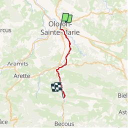
Randonnée Marche de 22 km à découvrir à Nouvelle-Aquitaine, Pyrénées-Atlantiques, Oloron-Sainte-Marie. Cette randonnée est proposée par tracegps.
Description
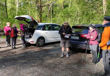
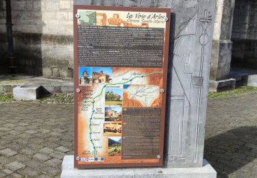
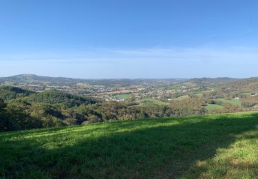
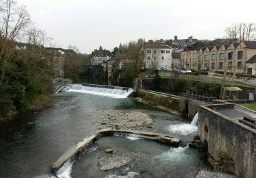
Première étape. Après Oloron se pose la question de deux ou trois étapes jusqu'au Somport. Chacun fera selon sa forme et son appréhension. Mais il faut savoir que la remontée de la vallée d'Aspe est très progressive et que seules les deux dernières heures présentent quelques difficultés. On peut aussi faire le choix d'emprunter la navette SNCF pour éviter de marcher le long de la N134 (gros trafic de poids-lourds). (source Chemin d'Arles)
Localisation
Commentaires
Randonnées à proximité
![Randonnée Course à pied Oloron-Sainte-Marie - OLORON Le camp de Cesar G4](https://media.geolcdn.com/t/375/260/e472b0d2-5d8f-43de-b167-1446063f7ed6.jpg&format=jpg&maxdim=2)
![Course à pied Course à pied](https://static1.geolcdn.com/sitytour/trail-icons/103.png)
Course à pied
![](/images/other/stat-length.png)
![](https://static1.geolcdn.com/siteimages/upload/files/16400158638029165_repeat_loop_refresh_sync_direction_icon.png)
![Randonnée A pied Oloron-Sainte-Marie - OLORON / LURBE - SAINT CHRISTAUD balisage GR 653 balisage - Photo](https://media.geolcdn.com/t/375/260/3e9828ef-bc7b-413a-8d74-e856dfe267ad.jpg&format=jpg&maxdim=2)
![A pied A pied](https://static1.geolcdn.com/sitytour/trail-icons/100.png)
A pied
![](/images/other/stat-length.png)
![](https://static1.geolcdn.com/siteimages/upload/files/16400158638029165_repeat_loop_refresh_sync_direction_icon.png)
![Randonnée Marche Oloron-Sainte-Marie - 2023 10 12 CHEMIN du PIÉMONT PYRÉNÉEN - 20ème étape 1ere partie : Oloron-Ste-Marie - Moumour - Orin - Géronce - St Goin - Gëus d’Oloron - l’Hopital st Blaise - Mauléon-Lichare. - Photo](https://media.geolcdn.com/t/375/260/ade2eb4a-a157-42cb-a64e-e7f217ca0550.jpg&format=jpg&maxdim=2)
![Marche Marche](https://static1.geolcdn.com/sitytour/trail-icons/101.png)
Marche
![](/images/other/stat-length.png)
![](https://static1.geolcdn.com/siteimages/upload/files/16400158638029165_repeat_loop_refresh_sync_direction_icon.png)
![Randonnée Marche Oloron-Sainte-Marie - OLORON ST MARIE Terra aventura - Photo](https://media.geolcdn.com/t/375/260/3d038a66-596b-48e0-83a1-a97e7a8939f0.jpg&format=jpg&maxdim=2)
![Marche Marche](https://static1.geolcdn.com/sitytour/trail-icons/101.png)
Marche
![](/images/other/stat-length.png)
![](https://static1.geolcdn.com/siteimages/upload/files/16400158638029165_repeat_loop_refresh_sync_direction_icon.png)
![Randonnée A pied Oloron-Sainte-Marie - OLORON Ecomobilité](https://media.geolcdn.com/t/375/260/a50ee7db-7fec-4ab2-ad39-c73d7a339336.jpg&format=jpg&maxdim=2)
![A pied A pied](https://static1.geolcdn.com/sitytour/trail-icons/100.png)
A pied
![](/images/other/stat-length.png)
![](https://static1.geolcdn.com/siteimages/upload/files/16400158638029165_repeat_loop_refresh_sync_direction_icon.png)
![Randonnée V.T.T. Estos - Tour crètes jusqu'à Louvie - Photo](https://media.geolcdn.com/t/375/260/ext.jpg?maxdim=2&url=https%3A%2F%2Fstatic1.geolcdn.com%2Fsiteimages%2Fupload%2Ffiles%2F1524743154velo.jpg)
![V.T.T. V.T.T.](https://static1.geolcdn.com/sitytour/trail-icons/202.png)
V.T.T.
![](/images/other/stat-length.png)
![](https://static1.geolcdn.com/siteimages/upload/files/16400158638029165_repeat_loop_refresh_sync_direction_icon.png)
![Randonnée Marche Goès - hors G4 fait - Photo](https://media.geolcdn.com/t/375/260/602e6491-4cac-49f3-a61f-acdc5409b468.jpg&format=jpg&maxdim=2)
![Marche Marche](https://static1.geolcdn.com/sitytour/trail-icons/101.png)
Marche
![](/images/other/stat-length.png)
![](https://static1.geolcdn.com/siteimages/upload/files/16400158638029165_repeat_loop_refresh_sync_direction_icon.png)
![Randonnée Marche Oloron-Sainte-Marie - G4 Haut doloron - Photo](https://media.geolcdn.com/t/375/260/62971c8b-edeb-4f82-8ed6-042d0d814008.jpg&format=jpg&maxdim=2)
![Marche Marche](https://static1.geolcdn.com/sitytour/trail-icons/101.png)
Marche
![](/images/other/stat-length.png)
![](https://static1.geolcdn.com/siteimages/upload/files/16400158638029165_repeat_loop_refresh_sync_direction_icon.png)
![Randonnée Marche Escout - Pont du Diable - Photo](https://media.geolcdn.com/t/375/260/dec9c24a-d815-4984-abec-fad7c1c2b03e.jpeg&format=jpg&maxdim=2)
![Marche Marche](https://static1.geolcdn.com/sitytour/trail-icons/101.png)
Marche
![](/images/other/stat-length.png)
![](https://static1.geolcdn.com/siteimages/upload/files/16400158638029165_repeat_loop_refresh_sync_direction_icon.png)