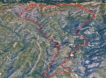
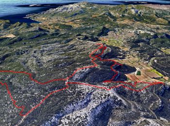
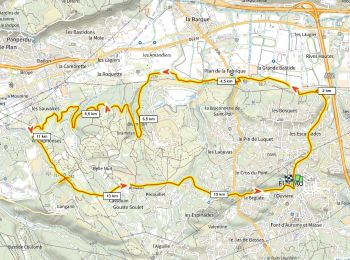
![](/images/other/stat-length.png)
- Randonnées
- Outdoor
- France
- Provence-Alpes-Côte d'Azur
- Bouches-du-Rhône
Bouches-du-Rhône, Provence-Alpes-Côte d'Azur : Les meilleures randonnées, itinéraires, parcours, balades et promenades
Bouches-du-Rhône : découvrez les meilleures randonnées : 9 374 pédestres, 1 715 à vélo ou VTT et 99 parcours équestres. Tous ces circuits, parcours, itinéraires et activités en plein air sont disponibles dans nos applications SityTrail pour smartphones et tablettes.
Les meilleurs parcours (11821)
![Randonnée Marche Allauch - Le Pilon du Roy - Photo](https://media.geolcdn.com/t/350/260/f70c47ce-637e-4170-ac86-2a2a395feaa2.jpg&format=jpg&maxdim=2)
![Marche Marche](https://static1.geolcdn.com/sitytour/trail-icons/101.png)
Km
Marche
![](/images/other/stat-length.png)
![](https://static1.geolcdn.com/siteimages/upload/files/1508320355ic_sort_den_pos_24dp.png)
![](https://static1.geolcdn.com/siteimages/upload/files/1508320355ic_sort_den_neg_24dp.png)
![](https://static1.geolcdn.com/siteimages/upload/files/16400158638029165_repeat_loop_refresh_sync_direction_icon.png)
• Parking 1353 Chemin de Mimet Allauch, Provence-Alpes-Côte d'Azur
![Randonnée Marche Roquefort-la-Bédoule - Grand Caunet, Cabanons, Vigie , Grotte Raymond, Ruines roquefort, Chapelle St andré - Photo](https://media.geolcdn.com/t/350/260/6da96041-d8db-45b9-9840-88b8ee06ae33.jpg&format=jpg&maxdim=2)
![Marche Marche](https://static1.geolcdn.com/sitytour/trail-icons/101.png)
Km
Marche
![](/images/other/stat-length.png)
![](https://static1.geolcdn.com/siteimages/upload/files/1508320355ic_sort_den_pos_24dp.png)
![](https://static1.geolcdn.com/siteimages/upload/files/1508320355ic_sort_den_neg_24dp.png)
![](https://static1.geolcdn.com/siteimages/upload/files/16400158638029165_repeat_loop_refresh_sync_direction_icon.png)
• .
![Randonnée Marche Aubagne - Aubagne - Le Garlaban - Autour de Pagnol - Photo](https://media.geolcdn.com/t/350/260/5276df7a-e0a5-4ee7-8341-ba0ac66cb09a.jpg&format=jpg&maxdim=2)
![Marche Marche](https://static1.geolcdn.com/sitytour/trail-icons/101.png)
Km
Marche
![](/images/other/stat-length.png)
![](https://static1.geolcdn.com/siteimages/upload/files/1508320355ic_sort_den_pos_24dp.png)
![](https://static1.geolcdn.com/siteimages/upload/files/1508320355ic_sort_den_neg_24dp.png)
![](https://static1.geolcdn.com/siteimages/upload/files/16400158638029165_repeat_loop_refresh_sync_direction_icon.png)
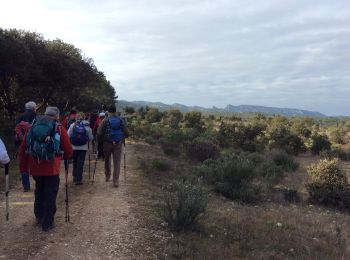
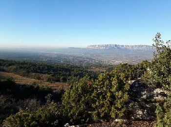
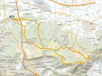
• Belle randonnée niveau N3S. Magnifiques points de vues tout au long du parcours. Passage par points de tournages des ...
![Randonnée Marche Saint-Rémy-de-Provence - Alpilles - Photo](https://media.geolcdn.com/t/350/260/3d9065b1-8760-4c6a-ad48-7d20309ee04e.jpg&format=jpg&maxdim=2)
![Marche Marche](https://static1.geolcdn.com/sitytour/trail-icons/101.png)
Km
Marche
![](/images/other/stat-length.png)
![](https://static1.geolcdn.com/siteimages/upload/files/1508320355ic_sort_den_pos_24dp.png)
![](https://static1.geolcdn.com/siteimages/upload/files/1508320355ic_sort_den_neg_24dp.png)
![](https://static1.geolcdn.com/siteimages/upload/files/16400158638029165_repeat_loop_refresh_sync_direction_icon.png)
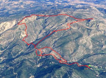
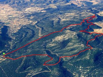
• Départ lac du Peirou, passage par la cheminée, rochers des 2 trous, Vallon des Amants
![Randonnée Vélo de route Cassis - Marseille Cassis Route - Photo](https://media.geolcdn.com/t/350/260/3a21b855-f65e-4548-9ca8-5f083c8a8d79.jpg&format=jpg&maxdim=2)
![Vélo de route Vélo de route](https://static1.geolcdn.com/sitytour/trail-icons/201.png)
Km
Vélo de route
![](/images/other/stat-length.png)
![](https://static1.geolcdn.com/siteimages/upload/files/1508320355ic_sort_den_pos_24dp.png)
![](https://static1.geolcdn.com/siteimages/upload/files/1508320355ic_sort_den_neg_24dp.png)
![](https://static1.geolcdn.com/siteimages/upload/files/16400158638029165_repeat_loop_refresh_sync_direction_icon.png)
• grand classique des cyclistes Marseillais. De la Pointe Rouge au port de cassis en passant par le col de la Gineste ...
![Randonnée V.T.T. Marseille - Trilogie des Calanques version courte - Photo](https://media.geolcdn.com/t/350/260/37b85b5c-5918-4ab9-a017-9d4bcff1fa49.jpg&format=jpg&maxdim=2)
![V.T.T. V.T.T.](https://static1.geolcdn.com/sitytour/trail-icons/202.png)
Km
V.T.T.
![](/images/other/stat-length.png)
![](https://static1.geolcdn.com/siteimages/upload/files/1508320355ic_sort_den_pos_24dp.png)
![](https://static1.geolcdn.com/siteimages/upload/files/1508320355ic_sort_den_neg_24dp.png)
![](https://static1.geolcdn.com/siteimages/upload/files/16400158638029165_repeat_loop_refresh_sync_direction_icon.png)
• Circuit en vélo, au départ de la Pointe Rouge, depuis notre atelier, 3 Avenue d'Odessa, 13008 Marseille. Alternance d...
![Randonnée Marche Orgon - PF-Orgon - La Plaine des Alpilles - Photo](https://media.geolcdn.com/t/350/260/fe67ed26-b4ff-45e2-a8d4-dd115c25befa.jpg&format=jpg&maxdim=2)
![Marche Marche](https://static1.geolcdn.com/sitytour/trail-icons/101.png)
Km
Marche
![](/images/other/stat-length.png)
![](https://static1.geolcdn.com/siteimages/upload/files/1508320355ic_sort_den_pos_24dp.png)
![](https://static1.geolcdn.com/siteimages/upload/files/1508320355ic_sort_den_neg_24dp.png)
![](https://static1.geolcdn.com/siteimages/upload/files/16400158638029165_repeat_loop_refresh_sync_direction_icon.png)
• Orgon - D24B direction Eygalières Parking : Route d'Eygalières après la borne "Route Jean Moulin" prendre le chemin à...
![Randonnée V.T.T. Trets - les contreforts du mont Olympe - Photo](https://media.geolcdn.com/t/350/260/ext.jpg?maxdim=2&url=https%3A%2F%2Fservices.sitytrail.com%2FGeolivesWS%2FDownloadMedia.ashx%3FTrailID%3D675672%26Media%3Dfix__20161223150806.jpg)
![V.T.T. V.T.T.](https://static1.geolcdn.com/sitytour/trail-icons/202.png)
Km
V.T.T.
![](/images/other/stat-length.png)
![](https://static1.geolcdn.com/siteimages/upload/files/1508320355ic_sort_den_pos_24dp.png)
![](https://static1.geolcdn.com/siteimages/upload/files/1508320355ic_sort_den_neg_24dp.png)
![](https://static1.geolcdn.com/siteimages/upload/files/16400158638029165_repeat_loop_refresh_sync_direction_icon.png)
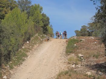
• rando VTT facile sur chemin DFCI qui vous aménera du pas de la Couelle au pied du mont Olympe, en passant par l'ermit...
![Marche Marche](https://static1.geolcdn.com/sitytour/trail-icons/101.png)
Km
Marche
![](/images/other/stat-length.png)
![](https://static1.geolcdn.com/siteimages/upload/files/1508320355ic_sort_den_pos_24dp.png)
![](https://static1.geolcdn.com/siteimages/upload/files/1508320355ic_sort_den_neg_24dp.png)
![](https://static1.geolcdn.com/siteimages/upload/files/16400158638029165_repeat_loop_refresh_sync_direction_icon.png)
• Départ : parking Espace Georges Duby
![Randonnée Marche Marseille - Luminy: Le chemin du Centaure - Photo](https://media.geolcdn.com/t/350/260/ext.jpg?maxdim=2&url=https%3A%2F%2Fservices.sitytrail.com%2FGeolivesWS%2FDownloadMedia.ashx%3FTrailID%3D179216%26Media%3D20130310112656.jpeg)
![Marche Marche](https://static1.geolcdn.com/sitytour/trail-icons/101.png)
Km
Marche
![](/images/other/stat-length.png)
![](https://static1.geolcdn.com/siteimages/upload/files/1508320355ic_sort_den_pos_24dp.png)
![](https://static1.geolcdn.com/siteimages/upload/files/1508320355ic_sort_den_neg_24dp.png)
![](https://static1.geolcdn.com/siteimages/upload/files/16400158638029165_repeat_loop_refresh_sync_direction_icon.png)
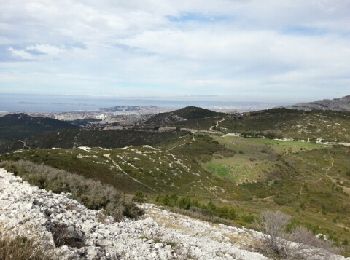
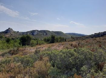
• Le parcours nous entraîne sous les contreforts du Mont Puget, point culminant du massif des calanques, sur des pistes...
![Marche Marche](https://static1.geolcdn.com/sitytour/trail-icons/101.png)
Km
Marche
![](/images/other/stat-length.png)
![](https://static1.geolcdn.com/siteimages/upload/files/1508320355ic_sort_den_pos_24dp.png)
![](https://static1.geolcdn.com/siteimages/upload/files/1508320355ic_sort_den_neg_24dp.png)
![](https://static1.geolcdn.com/siteimages/upload/files/16400158638029165_repeat_loop_refresh_sync_direction_icon.png)
![Randonnée Marche Ceyreste - Autour du Montounier 2eme version - Photo](https://media.geolcdn.com/t/350/260/aea50e59-26c4-4704-b6d5-ac40178213cc.jpg&format=jpg&maxdim=2)
![Marche Marche](https://static1.geolcdn.com/sitytour/trail-icons/101.png)
Km
Marche
![](/images/other/stat-length.png)
![](https://static1.geolcdn.com/siteimages/upload/files/1508320355ic_sort_den_pos_24dp.png)
![](https://static1.geolcdn.com/siteimages/upload/files/1508320355ic_sort_den_neg_24dp.png)
![](https://static1.geolcdn.com/siteimages/upload/files/16400158638029165_repeat_loop_refresh_sync_direction_icon.png)
![Randonnée Marche Roquefort-la-Bédoule - Grand Caunet, Autour du Montounier - Photo](https://media.geolcdn.com/t/350/260/f9c0beb6-6483-4b14-ba76-b33fa5e2208b.jpg&format=jpg&maxdim=2)
![Marche Marche](https://static1.geolcdn.com/sitytour/trail-icons/101.png)
Km
Marche
![](/images/other/stat-length.png)
![](https://static1.geolcdn.com/siteimages/upload/files/1508320355ic_sort_den_pos_24dp.png)
![](https://static1.geolcdn.com/siteimages/upload/files/1508320355ic_sort_den_neg_24dp.png)
![](https://static1.geolcdn.com/siteimages/upload/files/16400158638029165_repeat_loop_refresh_sync_direction_icon.png)
![Randonnée Marche Eyguières - PF-Eyguières - Le Tour du Mont Menu - MR - Photo](https://media.geolcdn.com/t/350/260/30e75c1f-6989-4149-84bb-d132222e741d.jpg&format=jpg&maxdim=2)
![Marche Marche](https://static1.geolcdn.com/sitytour/trail-icons/101.png)
Km
Marche
![](/images/other/stat-length.png)
![](https://static1.geolcdn.com/siteimages/upload/files/1508320355ic_sort_den_pos_24dp.png)
![](https://static1.geolcdn.com/siteimages/upload/files/1508320355ic_sort_den_neg_24dp.png)
![](https://static1.geolcdn.com/siteimages/upload/files/16400158638029165_repeat_loop_refresh_sync_direction_icon.png)
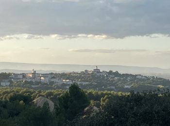
• A l'extrémité sud est du Massif des Alpilles et au dessus d'Eyguières, le Mont Menu se situe entre Les Opies - séparé...
![Randonnée Marche Charleval - PF-Charleval - Les Costes - Bois des Taillades - Cuou de Peyrou - Photo](https://media.geolcdn.com/t/350/260/67a220c4-295b-4d31-b693-d6441f3ed082.jpg&format=jpg&maxdim=2)
![Marche Marche](https://static1.geolcdn.com/sitytour/trail-icons/101.png)
Km
Marche
![](/images/other/stat-length.png)
![](https://static1.geolcdn.com/siteimages/upload/files/1508320355ic_sort_den_pos_24dp.png)
![](https://static1.geolcdn.com/siteimages/upload/files/1508320355ic_sort_den_neg_24dp.png)
![](https://static1.geolcdn.com/siteimages/upload/files/16400158638029165_repeat_loop_refresh_sync_direction_icon.png)
![Randonnée Marche Cassis - Les 3 Calanques coté Est - Port Miou - En Vau - Port Pin (2eme version) - Photo](https://media.geolcdn.com/t/350/260/6c8be29c-e655-4254-9b79-f66629a31e7b.jpg&format=jpg&maxdim=2)
![Marche Marche](https://static1.geolcdn.com/sitytour/trail-icons/101.png)
Km
Marche
![](/images/other/stat-length.png)
![](https://static1.geolcdn.com/siteimages/upload/files/1508320355ic_sort_den_pos_24dp.png)
![](https://static1.geolcdn.com/siteimages/upload/files/1508320355ic_sort_den_neg_24dp.png)
![](https://static1.geolcdn.com/siteimages/upload/files/16400158638029165_repeat_loop_refresh_sync_direction_icon.png)
![Randonnée Marche Cassis - Cassis - La couronne de Charlemagne - Cap canaille - Photo](https://media.geolcdn.com/t/350/260/3dbefdc1-c4a5-41cb-82fb-882826196b25.jpg&format=jpg&maxdim=2)
![Marche Marche](https://static1.geolcdn.com/sitytour/trail-icons/101.png)
Km
Marche
![](/images/other/stat-length.png)
![](https://static1.geolcdn.com/siteimages/upload/files/1508320355ic_sort_den_pos_24dp.png)
![](https://static1.geolcdn.com/siteimages/upload/files/1508320355ic_sort_den_neg_24dp.png)
![](https://static1.geolcdn.com/siteimages/upload/files/16400158638029165_repeat_loop_refresh_sync_direction_icon.png)
![V.T.T. V.T.T.](https://static1.geolcdn.com/sitytour/trail-icons/202.png)
Km
V.T.T.
![](/images/other/stat-length.png)
![](https://static1.geolcdn.com/siteimages/upload/files/1508320355ic_sort_den_pos_24dp.png)
![](https://static1.geolcdn.com/siteimages/upload/files/1508320355ic_sort_den_neg_24dp.png)
![](https://static1.geolcdn.com/siteimages/upload/files/16400158638029165_repeat_loop_refresh_sync_direction_icon.png)
• Petites routes et DFCI uniquement. Pas de passages délicats L’été, consulter la carte des conditions d’accès au massi...
![Marche Marche](https://static1.geolcdn.com/sitytour/trail-icons/101.png)
Km
Marche
![](/images/other/stat-length.png)
![](https://static1.geolcdn.com/siteimages/upload/files/1508320355ic_sort_den_pos_24dp.png)
![](https://static1.geolcdn.com/siteimages/upload/files/1508320355ic_sort_den_neg_24dp.png)
![](https://static1.geolcdn.com/siteimages/upload/files/16400158638029165_repeat_loop_refresh_sync_direction_icon.png)
• Départ halte routière de Fuveau. Passer l’école Roque Martine. Suivre l'ancienne voie ferrée Aubagne-Gardanne jusqu’a...
20 randonnées affichées sur 11821
Application GPS de randonnée GRATUITE
Activités
Régions proches
- Aix-en-Provence
- Allauch
- Alleins
- Arles
- Aubagne
- Aureille
- Auriol
- Aurons
- Barbentane
- Beaurecueil
- Belcodène
- Berre-l'Étang
- Bouc-Bel-Air
- Boulbon
- Cabannes
- Cabriès
- Cadolive
- Carnoux-en-Provence
- Carry-le-Rouet
- Cassis
- Ceyreste
- Charleval
- Châteauneuf-le-Rouge
- Châteauneuf-les-Martigues
- Châteaurenard
- Cornillon-Confoux
- Coudoux
- Cuges-les-Pins
- Éguilles
- Ensuès-la-Redonne
- Eygalières
- Eyguières
- Eyragues
- Fontvieille
- Fos-sur-Mer
- Fuveau
- Gardanne
- Gémenos
- Gignac-la-Nerthe
- Grans
- Graveson
- Gréasque
- Istres
- Jouques
- La Barben
- La Bouilladisse
- La Ciotat
- La Destrousse
- La Fare-les-Oliviers
- La Penne-sur-Huveaune
- La Roque-d'Anthéron
- Lamanon
- Lambesc
- Lançon-Provence
- Le Puy-Sainte-Réparade
- Le Rove
- Le Tholonet
- Les Baux-de-Provence
- Les Pennes-Mirabeau
- Maillane
- Mallemort
- Marignane
- Marseille
- Martigues
- Mas-Blanc-des-Alpilles
- Maussane-les-Alpilles
- Meyrargues
- Meyreuil
- Mimet
- Miramas
- Mollégès
- Mouriès
- Noves
- Orgon
- Paradou
- Pélissanne
- Peynier
- Peypin
- Peyrolles-en-Provence
- Plan-d'Orgon
- Plan-de-Cuques
- Port-Saint-Louis-du-Rhône
- Port-de-Bouc
- Puyloubier
- Rognac
- Rognes
- Rognonas
- Roquefort-la-Bédoule
- Roquevaire
- Rousset
- Saint-Andiol
- Saint-Antonin-sur-Bayon
- Saint-Cannat
- Saint-Chamas
- Saint-Estève-Janson
- Saint-Étienne-du-Grès
- Saint-Marc-Jaumegarde
- Saint-Martin-de-Crau
- Saint-Mitre-les-Remparts
- Saint-Paul-lès-Durance
- Saint-Pierre-de-Mézoargues
- Saint-Rémy-de-Provence
- Saint-Savournin
- Saint-Victoret
- Saintes-Maries-de-la-Mer
- Salon-de-Provence
- Sausset-les-Pins
- Sénas
- Septèmes-les-Vallons
- Simiane-Collongue
- Tarascon
- Trets
- Vauvenargues
- Velaux
- Venelles
- Ventabren
- Vernègues
- Verquières
- Vitrolles