![](/images/other/stat-length.png)
- Randonnées
- A pied
- France
- Occitanie
- Lozère
Lozère, Occitanie, A pied : Les meilleures randonnées, itinéraires, parcours, balades et promenades
Lozère : découvrez les meilleures randonnées : 145 a pied, 2881 marche, 29 marche nordique, 29 course à pied et 19 trail. Tous ces circuits, parcours, itinéraires et activités en plein air sont disponibles dans nos applications SityTrail pour smartphones et tablettes.
Les meilleurs parcours (3093)
![Randonnée Marche Le Rozier - 12 vase de Sèvres Chine ch. brunet - Photo](https://media.geolcdn.com/t/350/260/42bd83b0-7fd2-4ea6-86ca-ddc89ff015aa.jpg&format=jpg&maxdim=2)
![Marche Marche](https://static1.geolcdn.com/sitytour/trail-icons/101.png)
Km
Marche
![](/images/other/stat-length.png)
![](https://static1.geolcdn.com/siteimages/upload/files/1508320355ic_sort_den_pos_24dp.png)
![](https://static1.geolcdn.com/siteimages/upload/files/1508320355ic_sort_den_neg_24dp.png)
![](https://static1.geolcdn.com/siteimages/upload/files/16400158638029165_repeat_loop_refresh_sync_direction_icon.png)
• JP gene Jack sylv. 01.08.21
![Randonnée Marche Massegros Causses Gorges - Les Vignes - GR6 vers Le Rozier croisement sentier Cinglegros - 19km 425m 5h05 (0h55) - 2014 09 10 - Photo](https://media.geolcdn.com/t/350/260/ext.jpg?maxdim=2&url=https%3A%2F%2Fservices.sitytrail.com%2FGeolivesWS%2FDownloadMedia.ashx%3FTrailID%3D344246%26Media%3Dfix__20140910115908.jpg)
![Marche Marche](https://static1.geolcdn.com/sitytour/trail-icons/101.png)
Km
Marche
![](/images/other/stat-length.png)
![](https://static1.geolcdn.com/siteimages/upload/files/1508320355ic_sort_den_pos_24dp.png)
![](https://static1.geolcdn.com/siteimages/upload/files/1508320355ic_sort_den_neg_24dp.png)
![](https://static1.geolcdn.com/siteimages/upload/files/16400158638029165_repeat_loop_refresh_sync_direction_icon.png)
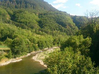
• Les Vignes - GR6 vers Le Rozier jusqu'au croisement avec le sentier Cinglegros - 19km 425m 5h05 (0h55) - 2014 09 10
![Randonnée Marche nordique Les Salces - Boucle du Loup depuis les Salces - Photo](https://media.geolcdn.com/t/350/260/84adfcce-71e7-4ab8-8fc1-9a84d109fca5.jpg&format=jpg&maxdim=2)
![Marche nordique Marche nordique](https://static1.geolcdn.com/sitytour/trail-icons/102.png)
Km
Marche nordique
![](/images/other/stat-length.png)
![](https://static1.geolcdn.com/siteimages/upload/files/1508320355ic_sort_den_pos_24dp.png)
![](https://static1.geolcdn.com/siteimages/upload/files/1508320355ic_sort_den_neg_24dp.png)
![](https://static1.geolcdn.com/siteimages/upload/files/16400158638029165_repeat_loop_refresh_sync_direction_icon.png)
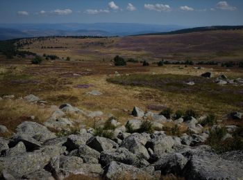
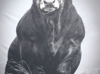
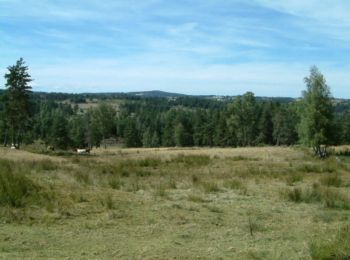
• Très beau parcours, alternant larges prairies où paissent paisiblement de belles vaches, points de vue panoramiques, ...
![Randonnée Marche nordique Trélans - Trélans Aubrac - Croix du Pal - Photo](https://media.geolcdn.com/t/350/260/693ad15b-186e-4874-89e5-6809bb1e1e64.jpg&format=jpg&maxdim=2)
![Marche nordique Marche nordique](https://static1.geolcdn.com/sitytour/trail-icons/102.png)
Km
Marche nordique
![](/images/other/stat-length.png)
![](https://static1.geolcdn.com/siteimages/upload/files/1508320355ic_sort_den_pos_24dp.png)
![](https://static1.geolcdn.com/siteimages/upload/files/1508320355ic_sort_den_neg_24dp.png)
![](https://static1.geolcdn.com/siteimages/upload/files/16400158638029165_repeat_loop_refresh_sync_direction_icon.png)
• Cette belle boucle, tantôt dans de très agréables sous-bois, mais plus souvent au travers de vastes et vertes prairi...
![Marche Marche](https://static1.geolcdn.com/sitytour/trail-icons/101.png)
Km
Marche
![](/images/other/stat-length.png)
![](https://static1.geolcdn.com/siteimages/upload/files/1508320355ic_sort_den_pos_24dp.png)
![](https://static1.geolcdn.com/siteimages/upload/files/1508320355ic_sort_den_neg_24dp.png)
![](https://static1.geolcdn.com/siteimages/upload/files/16400158638029165_repeat_loop_refresh_sync_direction_icon.png)
• Une agréable promenade en boucle, sans aucune difficulté, autour des monts Lozère. Le lieu est très fréquenté mais il...
![Randonnée Marche Prinsuéjols-Malbouzon - Prinsuejouls GR 65 - Photo](https://media.geolcdn.com/t/350/260/27679fa8-2676-42c2-9bc1-244f0333ecc6.jpg&format=jpg&maxdim=2)
![Marche Marche](https://static1.geolcdn.com/sitytour/trail-icons/101.png)
Km
Marche
![](/images/other/stat-length.png)
![](https://static1.geolcdn.com/siteimages/upload/files/1508320355ic_sort_den_pos_24dp.png)
![](https://static1.geolcdn.com/siteimages/upload/files/1508320355ic_sort_den_neg_24dp.png)
![](https://static1.geolcdn.com/siteimages/upload/files/16400158638029165_repeat_loop_refresh_sync_direction_icon.png)
![Randonnée Marche Marchastel - Rieutort lac san andeol cascade deroc - Photo](https://media.geolcdn.com/t/350/260/33c320b5-cb8a-49f6-87c9-e02583e6c71a.jpg&format=jpg&maxdim=2)
![Marche Marche](https://static1.geolcdn.com/sitytour/trail-icons/101.png)
Km
Marche
![](/images/other/stat-length.png)
![](https://static1.geolcdn.com/siteimages/upload/files/1508320355ic_sort_den_pos_24dp.png)
![](https://static1.geolcdn.com/siteimages/upload/files/1508320355ic_sort_den_neg_24dp.png)
![](https://static1.geolcdn.com/siteimages/upload/files/16400158638029165_repeat_loop_refresh_sync_direction_icon.png)
![Randonnée Marche Vialas - Sentier de l'Avès depuis le Coupétadou - Photo](https://media.geolcdn.com/t/350/260/ext.jpg?maxdim=2&url=https%3A%2F%2Fservices.sitytrail.com%2FGeolivesWS%2FDownloadMedia.ashx%3FTrailID%3D616629%26Media%3D20160818152623.jpg)
![Marche Marche](https://static1.geolcdn.com/sitytour/trail-icons/101.png)
Km
Marche
![](/images/other/stat-length.png)
![](https://static1.geolcdn.com/siteimages/upload/files/1508320355ic_sort_den_pos_24dp.png)
![](https://static1.geolcdn.com/siteimages/upload/files/1508320355ic_sort_den_neg_24dp.png)
![](https://static1.geolcdn.com/siteimages/upload/files/16400158638029165_repeat_loop_refresh_sync_direction_icon.png)
• Sentier découverte de l'Avès. Petite randonnée (PR) balisage jaune. Départ ici depuis notre chambre d'hôte, mais sino...
![Randonnée Marche La Bastide-Puylaurent - la bastide saint Laurent _ Le Bleymard - Photo](https://media.geolcdn.com/t/350/260/ext.jpg?maxdim=2&url=https%3A%2F%2Fservices.sitytrail.com%2FGeolivesWS%2FDownloadMedia.ashx%3FTrailID%3D463471%26Media%3Dfix__20150818152203.jpg)
![Marche Marche](https://static1.geolcdn.com/sitytour/trail-icons/101.png)
Km
Marche
![](/images/other/stat-length.png)
![](https://static1.geolcdn.com/siteimages/upload/files/1508320355ic_sort_den_pos_24dp.png)
![](https://static1.geolcdn.com/siteimages/upload/files/1508320355ic_sort_den_neg_24dp.png)
![](https://static1.geolcdn.com/siteimages/upload/files/16400158638029165_repeat_loop_refresh_sync_direction_icon.png)
• Stevenson
![Randonnée Marche Mont Lozère et Goulet - Bleymar _ Le Pont Montvert - Photo](https://media.geolcdn.com/t/350/260/ext.jpg?maxdim=2&url=https%3A%2F%2Fservices.sitytrail.com%2FGeolivesWS%2FDownloadMedia.ashx%3FTrailID%3D463465%26Media%3Dfix__20150819092348.jpg)
![Marche Marche](https://static1.geolcdn.com/sitytour/trail-icons/101.png)
Km
Marche
![](/images/other/stat-length.png)
![](https://static1.geolcdn.com/siteimages/upload/files/1508320355ic_sort_den_pos_24dp.png)
![](https://static1.geolcdn.com/siteimages/upload/files/1508320355ic_sort_den_neg_24dp.png)
![](https://static1.geolcdn.com/siteimages/upload/files/16400158638029165_repeat_loop_refresh_sync_direction_icon.png)
• Stevenson
![Randonnée Marche Naussac-Fontanes - naussac - Photo](https://media.geolcdn.com/t/350/260/ext.jpg?maxdim=2&url=https%3A%2F%2Fservices.sitytrail.com%2FGeolivesWS%2FDownloadMedia.ashx%3FTrailID%3D208949%26Media%3Dfix__20130730162442.jpg)
![Marche Marche](https://static1.geolcdn.com/sitytour/trail-icons/101.png)
Km
Marche
![](/images/other/stat-length.png)
![](https://static1.geolcdn.com/siteimages/upload/files/1508320355ic_sort_den_pos_24dp.png)
![](https://static1.geolcdn.com/siteimages/upload/files/1508320355ic_sort_den_neg_24dp.png)
![](https://static1.geolcdn.com/siteimages/upload/files/16400158638029165_repeat_loop_refresh_sync_direction_icon.png)
•
![Randonnée Marche Saint-Laurent-de-Muret - Tour des Monts d'Aubrac - De St Laurent de Muret au refuge des Rajas - Photo](https://media.geolcdn.com/t/350/260/ext.jpg?maxdim=2&url=https%3A%2F%2Fservices.sitytrail.com%2FGeolivesWS%2FDownloadMedia.ashx%3FTrailID%3D172691%26Media%3D14069_4.jpg)
![Marche Marche](https://static1.geolcdn.com/sitytour/trail-icons/101.png)
Km
Marche
![](/images/other/stat-length.png)
![](https://static1.geolcdn.com/siteimages/upload/files/1508320355ic_sort_den_pos_24dp.png)
![](https://static1.geolcdn.com/siteimages/upload/files/1508320355ic_sort_den_neg_24dp.png)
![](https://static1.geolcdn.com/siteimages/upload/files/16400158638029165_repeat_loop_refresh_sync_direction_icon.png)
• 3ème étape de ce circuit qui en comporte 6. Pour moi la plus belle étape ! Nous quittons les paysages de compagne boi...
![Randonnée Marche Florac Trois Rivières - Le Sentier des Couronnes - Florac - Photo](https://media.geolcdn.com/t/350/260/ext.jpg?maxdim=2&url=https%3A%2F%2Fservices.sitytrail.com%2FGeolivesWS%2FDownloadMedia.ashx%3FTrailID%3D129855%26Media%3D13413_6.jpg)
![Marche Marche](https://static1.geolcdn.com/sitytour/trail-icons/101.png)
Km
Marche
![](/images/other/stat-length.png)
![](https://static1.geolcdn.com/siteimages/upload/files/1508320355ic_sort_den_pos_24dp.png)
![](https://static1.geolcdn.com/siteimages/upload/files/1508320355ic_sort_den_neg_24dp.png)
![](https://static1.geolcdn.com/siteimages/upload/files/16400158638029165_repeat_loop_refresh_sync_direction_icon.png)
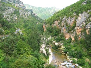
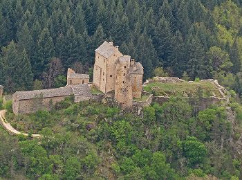
• Randonnée entre causse et falaises avec une vue sur les Cévennes et plus si beau temps dégagé. Parking: sous le châte...
![Randonnée Marche Gorges du Tarn Causses - Sentier de St-Chély du Tarn - Photo](https://media.geolcdn.com/t/350/260/ext.jpg?maxdim=2&url=https%3A%2F%2Fservices.sitytrail.com%2FGeolivesWS%2FDownloadMedia.ashx%3FTrailID%3D111743%26Media%3D8149_6.jpg)
![Marche Marche](https://static1.geolcdn.com/sitytour/trail-icons/101.png)
Km
Marche
![](/images/other/stat-length.png)
![](https://static1.geolcdn.com/siteimages/upload/files/1508320355ic_sort_den_pos_24dp.png)
![](https://static1.geolcdn.com/siteimages/upload/files/1508320355ic_sort_den_neg_24dp.png)
![](https://static1.geolcdn.com/siteimages/upload/files/16400158638029165_repeat_loop_refresh_sync_direction_icon.png)
• Circuit proposé par l’Office de Tourisme Gorges du Tarn – Grands Causses. C’est une randonnée pour les amateurs de vi...
![Randonnée Marche Fontans - Les Estrets - Les 4 Chemins - Chemin de Compostelle - Photo](https://media.geolcdn.com/t/350/260/ext.jpg?maxdim=2&url=https%3A%2F%2Fservices.sitytrail.com%2FGeolivesWS%2FDownloadMedia.ashx%3FTrailID%3D108149%26Media%3D206_6.jpg)
![Marche Marche](https://static1.geolcdn.com/sitytour/trail-icons/101.png)
Km
Marche
![](/images/other/stat-length.png)
![](https://static1.geolcdn.com/siteimages/upload/files/1508320355ic_sort_den_pos_24dp.png)
![](https://static1.geolcdn.com/siteimages/upload/files/1508320355ic_sort_den_neg_24dp.png)
![](https://static1.geolcdn.com/siteimages/upload/files/16400158638029165_repeat_loop_refresh_sync_direction_icon.png)
• Globalement montante (240m de dénivelée) cette étape du Chemin de Compostelle n'a pas été fatigante en raison du faib...
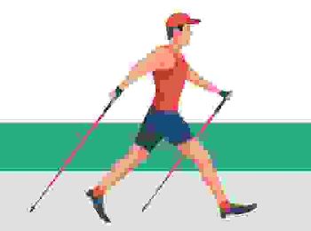
![Randonnée Marche nordique Saint-Paul-le-Froid - J1-1b matin MN 13km](https://media.geolcdn.com/t/350/260/1ef3be51-db85-433e-9f1e-ceceffa5a875.jpg&format=jpg&maxdim=2)
![Marche nordique Marche nordique](https://static1.geolcdn.com/sitytour/trail-icons/102.png)
Km
Marche nordique
![](/images/other/stat-length.png)
![](https://static1.geolcdn.com/siteimages/upload/files/1508320355ic_sort_den_pos_24dp.png)
![](https://static1.geolcdn.com/siteimages/upload/files/1508320355ic_sort_den_neg_24dp.png)
![](https://static1.geolcdn.com/siteimages/upload/files/16400158638029165_repeat_loop_refresh_sync_direction_icon.png)
• MN de 13km Groupe marche rapide 6km/h - Boucle Baraque des Bouviers par Forêt de St Paul le Froid, séjour Rcy en Géva...
![Randonnée Marche nordique Saint-Paul-le-Froid - J1-1a matin MN 12km](https://media.geolcdn.com/t/350/260/1ef3be51-db85-433e-9f1e-ceceffa5a875.jpg&format=jpg&maxdim=2)
![Marche nordique Marche nordique](https://static1.geolcdn.com/sitytour/trail-icons/102.png)
Km
Marche nordique
![](/images/other/stat-length.png)
![](https://static1.geolcdn.com/siteimages/upload/files/1508320355ic_sort_den_pos_24dp.png)
![](https://static1.geolcdn.com/siteimages/upload/files/1508320355ic_sort_den_neg_24dp.png)
![](https://static1.geolcdn.com/siteimages/upload/files/16400158638029165_repeat_loop_refresh_sync_direction_icon.png)
• MN de 12km Groupe marche normale 5.5km/h - Boucle Baraque des Bouviers par Forêt de St Paul le Froid, séjour Rcy Géva...
![Randonnée Marche Ispagnac - Ispagnac et Quezac - Photo](https://media.geolcdn.com/t/350/260/ext.jpg?maxdim=2&url=https%3A%2F%2Fservices.sitytrail.com%2FGeolivesWS%2FDownloadMedia.ashx%3FTrailID%3D449646%26Media%3Dfix__20150725172954.jpg)
![Marche Marche](https://static1.geolcdn.com/sitytour/trail-icons/101.png)
Km
Marche
![](/images/other/stat-length.png)
![](https://static1.geolcdn.com/siteimages/upload/files/1508320355ic_sort_den_pos_24dp.png)
![](https://static1.geolcdn.com/siteimages/upload/files/1508320355ic_sort_den_neg_24dp.png)
![](https://static1.geolcdn.com/siteimages/upload/files/16400158638029165_repeat_loop_refresh_sync_direction_icon.png)
• 2 rives du Tarn
![Randonnée Marche Les Bondons - Autour de Ruas - Photo](https://media.geolcdn.com/t/350/260/ext.jpg?maxdim=2&url=https%3A%2F%2Fservices.sitytrail.com%2FGeolivesWS%2FDownloadMedia.ashx%3FTrailID%3D129874%26Media%3D13440_2.jpg)
![Marche Marche](https://static1.geolcdn.com/sitytour/trail-icons/101.png)
Km
Marche
![](/images/other/stat-length.png)
![](https://static1.geolcdn.com/siteimages/upload/files/1508320355ic_sort_den_pos_24dp.png)
![](https://static1.geolcdn.com/siteimages/upload/files/1508320355ic_sort_den_neg_24dp.png)
![](https://static1.geolcdn.com/siteimages/upload/files/16400158638029165_repeat_loop_refresh_sync_direction_icon.png)
• Le départ se situe à la sortie du hameau très encaissé de Ruas. Ce circuit, proche des mines d'uranium et de chaos ro...
![Randonnée Marche Mont Lozère et Goulet - Chemin de Stevenson - Le Bleymard vers Le Pont de Montvert - Photo](https://media.geolcdn.com/t/350/260/ext.jpg?maxdim=2&url=https%3A%2F%2Fservices.sitytrail.com%2FGeolivesWS%2FDownloadMedia.ashx%3FTrailID%3D109272%26Media%3D3392_1.jpg)
![Marche Marche](https://static1.geolcdn.com/sitytour/trail-icons/101.png)
Km
Marche
![](/images/other/stat-length.png)
![](https://static1.geolcdn.com/siteimages/upload/files/1508320355ic_sort_den_pos_24dp.png)
![](https://static1.geolcdn.com/siteimages/upload/files/1508320355ic_sort_den_neg_24dp.png)
![](https://static1.geolcdn.com/siteimages/upload/files/16400158638029165_repeat_loop_refresh_sync_direction_icon.png)
• Randonnée sur le Chemin de Stevenson à travers la Haute Loire, la Lozère, l'Ardèche et le Gard de l'Auvergne aux Céve...
20 randonnées affichées sur 3093
Application GPS de randonnée GRATUITE
Activités
Régions proches
- Albaret-Sainte-Marie
- Albaret-le-Comtal
- Allenc
- Altier
- Antrenas
- Arzenc-d'Apcher
- Arzenc-de-Randon
- Auroux
- Badaroux
- Balsièges
- Banassac-Canilhac
- Barjac
- Barre-des-Cévennes
- Bassurels
- Bédouès-Cocurès
- Bel-Air-Val-d'Ance
- Blavignac
- Bourgs sur Colagne
- Brenoux
- Brion
- Cans et Cévennes
- Cassagnas
- Chadenet
- Chanac
- Chastanier
- Chastel-Nouvel
- Châteauneuf-de-Randon
- Chauchailles
- Chaudeyrac
- Chaulhac
- Cheylard-l'Évêque
- Cubières
- Cubiérettes
- Cultures
- Esclanèdes
- Florac Trois Rivières
- Fontans
- Fournels
- Fraissinet-de-Fourques
- Gabriac
- Gabrias
- Gatuzières
- Gorges du Tarn Causses
- Grandrieu
- Grandvals
- Grèzes
- Hures-la-Parade
- Ispagnac
- Julianges
- La Bastide-Puylaurent
- La Canourgue
- La Fage-Montivernoux
- La Fage-Saint-Julien
- La Malène
- La Panouse
- La Tieule
- Lachamp-Ribennes
- Lajo
- Langogne
- Lanuéjols
- Laubert
- Laval-du-Tarn
- Le Born
- Le Buisson
- Le Collet-de-Dèze
- Le Malzieu-Forain
- Le Malzieu-Ville
- Le Pompidou
- Le Rozier
- Les Bessons
- Les Bondons
- Les Hermaux
- Les Laubies
- Les Monts-Verts
- Les Salces
- Les Salelles
- Luc
- Marchastel
- Marvejols
- Mas-Saint-Chély
- Massegros Causses Gorges
- Mende
- Meyrueis
- Moissac-Vallée-Française
- Molezon
- Mont Lozère et Goulet
- Montbel
- Montrodat
- Monts-de-Randon
- Nasbinals
- Naussac-Fontanes
- Noalhac
- Palhers
- Paulhac-en-Margeride
- Pelouse
- Peyre en Aubrac
- Pied-de-Borne
- Pierrefiche
- Pont de Montvert - Sud Mont Lozère
- Pourcharesses
- Prévenchères
- Prinsuéjols-Malbouzon
- Prunières
- Recoules-d'Aubrac
- Recoules-de-Fumas
- Rimeize
- Rocles
- Rousses
- Saint Bonnet-Laval
- Saint-Alban-sur-Limagnole
- Saint-André-Capcèze
- Saint-André-de-Lancize
- Saint-Bauzile
- Saint-Bonnet-de-Chirac
- Saint-Chély-d'Apcher
- Saint-Denis-en-Margeride
- Saint-Étienne-Vallée-Française
- Saint-Étienne-du-Valdonnez
- Saint-Flour-de-Mercoire
- Saint-Frézal-d'Albuges
- Saint-Gal
- Saint-Germain-de-Calberte
- Saint-Germain-du-Teil
- Saint-Hilaire-de-Lavit
- Saint-Jean-la-Fouillouse
- Saint-Juéry
- Saint-Julien-des-Points
- Saint-Laurent-de-Muret
- Saint-Laurent-de-Veyrès
- Saint-Léger-de-Peyre
- Saint-Léger-du-Malzieu
- Saint-Martin-de-Boubaux
- Saint-Martin-de-Lansuscle
- Saint-Michel-de-Dèze
- Saint-Paul-le-Froid
- Saint-Pierre-de-Nogaret
- Saint-Pierre-des-Tripiers
- Saint-Pierre-le-Vieux
- Saint-Privat-de-Vallongue
- Saint-Privat-du-Fau
- Saint-Saturnin
- Saint-Sauveur-de-Ginestoux
- Sainte-Croix-Vallée-Française
- Sainte-Eulalie
- Sainte-Hélène
- Serverette
- Termes
- Trélans
- Vebron
- Ventalon en Cévennes
- Vialas
- Villefort