![](/images/other/stat-length.png)
- Randonnées
- A pied
- France
- Provence-Alpes-Côte d'Azur
- Alpes-Maritimes
- Saint-Vallier-de-Thiey
Saint-Vallier-de-Thiey, Alpes-Maritimes, A pied : Les meilleures randonnées, itinéraires, parcours, balades et promenades
Saint-Vallier-de-Thiey : découvrez les meilleures randonnées : 18 a pied, 163 marche, 2 marche nordique et 1 trail. Tous ces circuits, parcours, itinéraires et activités en plein air sont disponibles dans nos applications SityTrail pour smartphones et tablettes.
Les meilleurs parcours (184)
![Randonnée Marche Saint-Vallier-de-Thiey - Arche de Ponadieu Source de la Pare Baou Mourine Vieux Pont - Photo](https://media.geolcdn.com/t/350/260/7bf7c645-d759-4e3b-9f63-302e7218f005.jpg&format=jpg&maxdim=2)
![Marche Marche](https://static1.geolcdn.com/sitytour/trail-icons/101.png)
Km
Marche
![](/images/other/stat-length.png)
![](https://static1.geolcdn.com/siteimages/upload/files/1508320355ic_sort_den_pos_24dp.png)
![](https://static1.geolcdn.com/siteimages/upload/files/1508320355ic_sort_den_neg_24dp.png)
![](https://static1.geolcdn.com/siteimages/upload/files/16400158638029165_repeat_loop_refresh_sync_direction_icon.png)
• Depuis St Vallier de Thiey
![Randonnée Marche Saint-Vallier-de-Thiey - St Vallier de Thiey - Aqueduc de Belletrud - Arche de Ponadieu - Photo](https://media.geolcdn.com/t/350/260/102f751b-e867-453b-847f-fc313f16fe9f.jpg&format=jpg&maxdim=2)
![Marche Marche](https://static1.geolcdn.com/sitytour/trail-icons/101.png)
Km
Marche
![](/images/other/stat-length.png)
![](https://static1.geolcdn.com/siteimages/upload/files/1508320355ic_sort_den_pos_24dp.png)
![](https://static1.geolcdn.com/siteimages/upload/files/1508320355ic_sort_den_neg_24dp.png)
![](https://static1.geolcdn.com/siteimages/upload/files/16400158638029165_repeat_loop_refresh_sync_direction_icon.png)
• Rando très sportive de l'aqueduc jusqu'à la passerelle des Malines. Parking route de la Siagne - Vieux Pont - A/R au ...
![Randonnée Marche Saint-Vallier-de-Thiey - canau - Photo](https://media.geolcdn.com/t/350/260/ca899ab5-eb13-42e5-a84d-3c58455096f9.jpg&format=jpg&maxdim=2)
![Marche Marche](https://static1.geolcdn.com/sitytour/trail-icons/101.png)
Km
Marche
![](/images/other/stat-length.png)
![](https://static1.geolcdn.com/siteimages/upload/files/1508320355ic_sort_den_pos_24dp.png)
![](https://static1.geolcdn.com/siteimages/upload/files/1508320355ic_sort_den_neg_24dp.png)
![](https://static1.geolcdn.com/siteimages/upload/files/16400158638029165_repeat_loop_refresh_sync_direction_icon.png)
• dure
![Randonnée Marche Saint-Vallier-de-Thiey - Saint-Vallier-de-Thiey - la Montagne de Thiey - 14.9km 720m 4h55 (0h35) - 2015 06 11 - Photo](https://media.geolcdn.com/t/350/260/ext.jpg?maxdim=2&url=https%3A%2F%2Fservices.sitytrail.com%2FGeolivesWS%2FDownloadMedia.ashx%3FTrailID%3D435403%26Media%3Dfix__20150611140933.jpg)
![Marche Marche](https://static1.geolcdn.com/sitytour/trail-icons/101.png)
Km
Marche
![](/images/other/stat-length.png)
![](https://static1.geolcdn.com/siteimages/upload/files/1508320355ic_sort_den_pos_24dp.png)
![](https://static1.geolcdn.com/siteimages/upload/files/1508320355ic_sort_den_neg_24dp.png)
![](https://static1.geolcdn.com/siteimages/upload/files/16400158638029165_repeat_loop_refresh_sync_direction_icon.png)
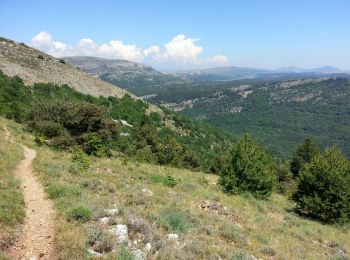
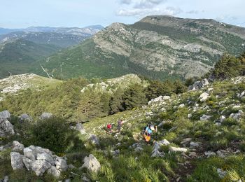
• Saint-Vallier-de-Thiey - la Montagne de Thiey (du parking de Nans) - 14.9km 720m 4h55 (0h35) - 2015 06 11
![Randonnée Marche Saint-Vallier-de-Thiey - St Vallier : Colle du maçon doublier - Photo](https://media.geolcdn.com/t/350/260/4e394125-44db-4de9-b615-b5e106949b4d.jpg&format=jpg&maxdim=2)
![Marche Marche](https://static1.geolcdn.com/sitytour/trail-icons/101.png)
Km
Marche
![](/images/other/stat-length.png)
![](https://static1.geolcdn.com/siteimages/upload/files/1508320355ic_sort_den_pos_24dp.png)
![](https://static1.geolcdn.com/siteimages/upload/files/1508320355ic_sort_den_neg_24dp.png)
![](https://static1.geolcdn.com/siteimages/upload/files/16400158638029165_repeat_loop_refresh_sync_direction_icon.png)
• Boucle au départ col du Ferrier passages délicats en lapiaz et un peu de hors sentier IBP=93
![Marche Marche](https://static1.geolcdn.com/sitytour/trail-icons/101.png)
Km
Marche
![](/images/other/stat-length.png)
![](https://static1.geolcdn.com/siteimages/upload/files/1508320355ic_sort_den_pos_24dp.png)
![](https://static1.geolcdn.com/siteimages/upload/files/1508320355ic_sort_den_neg_24dp.png)
![](https://static1.geolcdn.com/siteimages/upload/files/16400158638029165_repeat_loop_refresh_sync_direction_icon.png)
• IBP Orange 59
![Randonnée Marche Saint-Vallier-de-Thiey - St Vallier : Pare2 - Photo](https://media.geolcdn.com/t/350/260/0e23e1f7-5365-422d-9e17-aca855b1fa8e.jpeg&format=jpg&maxdim=2)
![Marche Marche](https://static1.geolcdn.com/sitytour/trail-icons/101.png)
Km
Marche
![](/images/other/stat-length.png)
![](https://static1.geolcdn.com/siteimages/upload/files/1508320355ic_sort_den_pos_24dp.png)
![](https://static1.geolcdn.com/siteimages/upload/files/1508320355ic_sort_den_neg_24dp.png)
![](https://static1.geolcdn.com/siteimages/upload/files/16400158638029165_repeat_loop_refresh_sync_direction_icon.png)
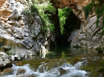
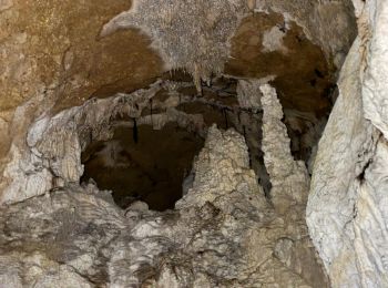
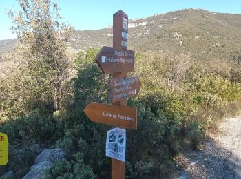
• Au programme, - arche de Ponadieu - grotte des deux Goules (visitée) - les tunnels de Belletrud - source de la Pare r...
![Marche Marche](https://static1.geolcdn.com/sitytour/trail-icons/101.png)
Km
Marche
![](/images/other/stat-length.png)
![](https://static1.geolcdn.com/siteimages/upload/files/1508320355ic_sort_den_pos_24dp.png)
![](https://static1.geolcdn.com/siteimages/upload/files/1508320355ic_sort_den_neg_24dp.png)
![](https://static1.geolcdn.com/siteimages/upload/files/16400158638029165_repeat_loop_refresh_sync_direction_icon.png)
• IBP Rouge 76
![Randonnée Marche Saint-Vallier-de-Thiey - Montagne de Thiey 2 - Photo](https://media.geolcdn.com/t/350/260/e67f18b8-11b7-47ac-9962-78c54d88cde0.jpg&format=jpg&maxdim=2)
![Marche Marche](https://static1.geolcdn.com/sitytour/trail-icons/101.png)
Km
Marche
![](/images/other/stat-length.png)
![](https://static1.geolcdn.com/siteimages/upload/files/1508320355ic_sort_den_pos_24dp.png)
![](https://static1.geolcdn.com/siteimages/upload/files/1508320355ic_sort_den_neg_24dp.png)
![](https://static1.geolcdn.com/siteimages/upload/files/16400158638029165_repeat_loop_refresh_sync_direction_icon.png)
• Depuis le Pont de Nans
![Randonnée Marche Saint-Vallier-de-Thiey - St Vallier : Ponadieu et Pare - Photo](https://media.geolcdn.com/t/350/260/cd1c5cbe-cdfc-442d-b46e-04ba15662bae.jpeg&format=jpg&maxdim=2)
![Marche Marche](https://static1.geolcdn.com/sitytour/trail-icons/101.png)
Km
Marche
![](/images/other/stat-length.png)
![](https://static1.geolcdn.com/siteimages/upload/files/1508320355ic_sort_den_pos_24dp.png)
![](https://static1.geolcdn.com/siteimages/upload/files/1508320355ic_sort_den_neg_24dp.png)
![](https://static1.geolcdn.com/siteimages/upload/files/16400158638029165_repeat_loop_refresh_sync_direction_icon.png)
• IBP = 102 Difficulté : Cette randonnée est classée Assez Difficile car elle présente les 2 difficultés suivantes : • ...
![Randonnée Marche Saint-Vallier-de-Thiey - montagne de Thiey-forêt de Nans-19-04-23 - Photo](https://media.geolcdn.com/t/350/260/79feccfc-c2d1-45cf-88b8-7806bcf91224.jpg&format=jpg&maxdim=2)
![Marche Marche](https://static1.geolcdn.com/sitytour/trail-icons/101.png)
Km
Marche
![](/images/other/stat-length.png)
![](https://static1.geolcdn.com/siteimages/upload/files/1508320355ic_sort_den_pos_24dp.png)
![](https://static1.geolcdn.com/siteimages/upload/files/1508320355ic_sort_den_neg_24dp.png)
![](https://static1.geolcdn.com/siteimages/upload/files/16400158638029165_repeat_loop_refresh_sync_direction_icon.png)
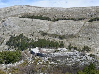
• Maison forestière de Nans-forêt de Nans-source de Thiey-sommet de la montagne de Thiey 1553 m- St Hubert-le gros Adre...
![Randonnée Marche Saint-Vallier-de-Thiey - Panadieu-ancienne Rte Napoléon de St Vallier à Escragnolles-18-04-23 - Photo](https://media.geolcdn.com/t/350/260/2e9aac37-8793-4eae-b02a-560b2674cf9a.jpg&format=jpg&maxdim=2)
![Marche Marche](https://static1.geolcdn.com/sitytour/trail-icons/101.png)
Km
Marche
![](/images/other/stat-length.png)
![](https://static1.geolcdn.com/siteimages/upload/files/1508320355ic_sort_den_pos_24dp.png)
![](https://static1.geolcdn.com/siteimages/upload/files/1508320355ic_sort_den_neg_24dp.png)
![](https://static1.geolcdn.com/siteimages/upload/files/16400158638029165_repeat_loop_refresh_sync_direction_icon.png)
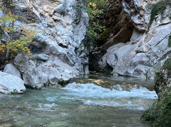
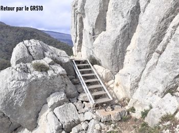
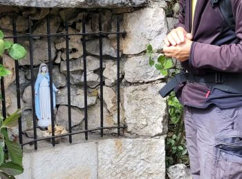
• Pk de la citerne-le Ponadieu-la Siagne-grotte des 2 Goules-GR 510-chapelle St Jean- le vieux pont-Ancienne rte Napolé...
![Randonnée Marche Saint-Vallier-de-Thiey - Col du Pilon : Colle maçon et haut Montet - Photo](https://media.geolcdn.com/t/350/260/1f50f7c4-1c1b-4b0f-8895-c647368ee7d1.jpg&format=jpg&maxdim=2)
![Marche Marche](https://static1.geolcdn.com/sitytour/trail-icons/101.png)
Km
Marche
![](/images/other/stat-length.png)
![](https://static1.geolcdn.com/siteimages/upload/files/1508320355ic_sort_den_pos_24dp.png)
![](https://static1.geolcdn.com/siteimages/upload/files/1508320355ic_sort_den_neg_24dp.png)
![](https://static1.geolcdn.com/siteimages/upload/files/16400158638029165_repeat_loop_refresh_sync_direction_icon.png)
• Depuis le Col du Pilon et le col du Ferrié A signaler une partie bitumée vers le pk 16 sur 2-3 km... La partie final...
![Randonnée Marche Saint-Vallier-de-Thiey - Face Sud de la montagne de Thiey - Photo](https://media.geolcdn.com/t/350/260/be33fdb9-a342-495a-acea-9826d207c77b.jpg&format=jpg&maxdim=2)
![Marche Marche](https://static1.geolcdn.com/sitytour/trail-icons/101.png)
Km
Marche
![](/images/other/stat-length.png)
![](https://static1.geolcdn.com/siteimages/upload/files/1508320355ic_sort_den_pos_24dp.png)
![](https://static1.geolcdn.com/siteimages/upload/files/1508320355ic_sort_den_neg_24dp.png)
![](https://static1.geolcdn.com/siteimages/upload/files/16400158638029165_repeat_loop_refresh_sync_direction_icon.png)
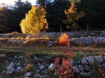
• Belle balade d'automne avec beaucoup de couleurs sur les arbres, en particuliers les hetres
![Randonnée Marche Saint-Vallier-de-Thiey - couche de soleil au col du ferrier - Photo](https://media.geolcdn.com/t/350/260/15d1109c-058b-46fe-983d-4905a1293ce2.jpg&format=jpg&maxdim=2)
![Marche Marche](https://static1.geolcdn.com/sitytour/trail-icons/101.png)
Km
Marche
![](/images/other/stat-length.png)
![](https://static1.geolcdn.com/siteimages/upload/files/1508320355ic_sort_den_pos_24dp.png)
![](https://static1.geolcdn.com/siteimages/upload/files/1508320355ic_sort_den_neg_24dp.png)
![](https://static1.geolcdn.com/siteimages/upload/files/16400158638029165_repeat_loop_refresh_sync_direction_icon.png)
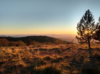
• Ballade automnale par grand beau temps. Visibilité sur toute la côte et début des superbes couleurs de l'automne
![Randonnée A pied Saint-Vallier-de-Thiey - Arche du Ponadieu - Photo](https://media.geolcdn.com/t/350/260/7316e039-d176-446d-9243-83f74ffa2b21.jpeg&format=jpg&maxdim=2)
![A pied A pied](https://static1.geolcdn.com/sitytour/trail-icons/100.png)
Km
A pied
![](/images/other/stat-length.png)
![](https://static1.geolcdn.com/siteimages/upload/files/1508320355ic_sort_den_pos_24dp.png)
![](https://static1.geolcdn.com/siteimages/upload/files/1508320355ic_sort_den_neg_24dp.png)
![](https://static1.geolcdn.com/siteimages/upload/files/16400158638029165_repeat_loop_refresh_sync_direction_icon.png)
• Randonnée pédestre - Au départ de Saint-Vallier-de-Thiey, parking du Calvaire (715 m) Site web: https://randoxygene....
![Randonnée A pied Saint-Vallier-de-Thiey - Col du Pilon La Marbrière Route des 3 Ponts Croix de Cabris 3543 ET - Photo](https://media.geolcdn.com/t/350/260/7f681fdb-57a7-4335-aed6-057b71e03ebe.jpg&format=jpg&maxdim=2)
![A pied A pied](https://static1.geolcdn.com/sitytour/trail-icons/100.png)
Km
A pied
![](/images/other/stat-length.png)
![](https://static1.geolcdn.com/siteimages/upload/files/1508320355ic_sort_den_pos_24dp.png)
![](https://static1.geolcdn.com/siteimages/upload/files/1508320355ic_sort_den_neg_24dp.png)
![](https://static1.geolcdn.com/siteimages/upload/files/16400158638029165_repeat_loop_refresh_sync_direction_icon.png)
• Entre 1 km et 1,500 km monter un peu plus haut que le tracé pour trouver le sentier à droite (photo couleur verte) en...
![Randonnée Marche Saint-Vallier-de-Thiey - Montagne de Thiey - Photo](https://media.geolcdn.com/t/350/260/89e6ec94-41b6-4912-a5f2-d18990c28a55.jpg&format=jpg&maxdim=2)
![Marche Marche](https://static1.geolcdn.com/sitytour/trail-icons/101.png)
Km
Marche
![](/images/other/stat-length.png)
![](https://static1.geolcdn.com/siteimages/upload/files/1508320355ic_sort_den_pos_24dp.png)
![](https://static1.geolcdn.com/siteimages/upload/files/1508320355ic_sort_den_neg_24dp.png)
![](https://static1.geolcdn.com/siteimages/upload/files/16400158638029165_repeat_loop_refresh_sync_direction_icon.png)
![Randonnée Marche Saint-Vallier-de-Thiey - Pont de Nans : la montagne de Thiey - Photo](https://media.geolcdn.com/t/350/260/e9608c3f-7de0-4493-994b-dc90524ad766.jpg&format=jpg&maxdim=2)
![Marche Marche](https://static1.geolcdn.com/sitytour/trail-icons/101.png)
Km
Marche
![](/images/other/stat-length.png)
![](https://static1.geolcdn.com/siteimages/upload/files/1508320355ic_sort_den_pos_24dp.png)
![](https://static1.geolcdn.com/siteimages/upload/files/1508320355ic_sort_den_neg_24dp.png)
![](https://static1.geolcdn.com/siteimages/upload/files/16400158638029165_repeat_loop_refresh_sync_direction_icon.png)
• Boucle hivernale au départ du Pont de Nans. Ascension de la montagne de Thiey qui se fait sans difficultés particuliè...
![Randonnée Marche Saint-Vallier-de-Thiey - St Vallier de Thiey : colle maçon2 - Photo](https://media.geolcdn.com/t/350/260/43790db2-3e3a-4090-aaff-4b7b98f9a710.jpg&format=jpg&maxdim=2)
![Marche Marche](https://static1.geolcdn.com/sitytour/trail-icons/101.png)
Km
Marche
![](/images/other/stat-length.png)
![](https://static1.geolcdn.com/siteimages/upload/files/1508320355ic_sort_den_pos_24dp.png)
![](https://static1.geolcdn.com/siteimages/upload/files/1508320355ic_sort_den_neg_24dp.png)
![](https://static1.geolcdn.com/siteimages/upload/files/16400158638029165_repeat_loop_refresh_sync_direction_icon.png)
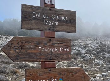
• Départ col du Ferrier Colle du Maçon Col du Clapier Haut Montet Le Doublier IBP = 73
20 randonnées affichées sur 184
Application GPS de randonnée GRATUITE