![](/images/other/stat-length.png)
![Excursión Senderismo Sarcenas - Chamechaude - Photo](https://media.geolcdn.com/t/1900/400/ext.pjpeg?maxdim=2&url=https%3A%2F%2Fstatic1.geolcdn.com%2Fsiteimages%2Fupload%2Ffiles%2F1553511878bg_sport_marche.png)
Chamechaude
Phil36
Usuario
![Longitud](/images/other/stat-length.png)
Longitud
8 km
![Altitud máxima](https://static1.geolcdn.com/siteimages/upload/files/1508320355ic_sort_altitude_max_24dp.png)
Altitud máxima
2034 m
![Desnivel positivo](https://static1.geolcdn.com/siteimages/upload/files/1508320355ic_sort_den_pos_24dp.png)
Desnivel positivo
708 m
![Km-Effort](/images/other/stat-length.png)
Km-Effort
17,4 km
![Altitud mínima](https://static1.geolcdn.com/siteimages/upload/files/1508320355ic_sort_altitude_min_24dp.png)
Altitud mínima
1328 m
![Desnivel negativo](https://static1.geolcdn.com/siteimages/upload/files/1508320355ic_sort_den_neg_24dp.png)
Desnivel negativo
708 m
![Boucle](https://static1.geolcdn.com/siteimages/upload/files/16400158638029165_repeat_loop_refresh_sync_direction_icon.png)
Boucle
Sí
Fecha de creación :
2018-04-17 22:44:49.04
Última modificación :
2018-04-17 22:44:49.04
![Senderismo](https://static1.geolcdn.com/sitytour/trail-icons/101.png)
3h32
Dificultad : Difícil
![Escanee este código QR para abrir la excursión en la aplicación SityTrail](https://capi.geolives.com/qq0zvz2zws4bq2lad0pu/sitytour/trails/929030/qr.png?size=200)
Aplicación GPS de excursión GRATIS
A propósito
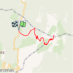
Ruta Senderismo de 8 km a descubrir en Auvergne-Rhône-Alpes, Isère, Sarcenas. Esta ruta ha sido propuesta por Phil36.
Descripción
Chamechaude est le plus haut sommet du massif de Chartreuse (2082m).Lieu priviligié pour tous ceux qui aiment le dénivelé. Il offre un panorama exceptionnel.
Localización
País:
France
Región :
Auvergne-Rhône-Alpes
Departamento/provincia :
Isère
Municipio :
Sarcenas
Localidad:
Unknown
Salida:(Dec)
Salida:(UTM)
716985 ; 5018907 (31T) N.
Comentarios
Excursiones cerca
![Excursión Senderismo Saint-Pierre-de-Chartreuse - Le Charmant Som depuis le Col de la Charmette - Photo](https://media.geolcdn.com/t/375/260/ext.jpg?maxdim=2&url=https%3A%2F%2Fservices.sitytrail.com%2FGeolivesWS%2FDownloadMedia.ashx%3FTrailID%3D104129%26Media%3D7202_1.jpg)
![Senderismo Senderismo](https://static1.geolcdn.com/sitytour/trail-icons/101.png)
Le Charmant Som depuis le Col de la Charmette
Senderismo
Medio
(2)
Saint-Pierre-de-Chartreuse,
Auvergne-Rhône-Alpes,
Isère,
France
![](/images/other/stat-length.png)
8,9 km | 17,3 km-effort
5h 0min
![](https://static1.geolcdn.com/siteimages/upload/files/16400158638029165_repeat_loop_refresh_sync_direction_icon.png)
Sí
![Excursión Senderismo Saint-Pierre-de-Chartreuse - Le Charmant Som 1867m, par les dalles - Photo](https://media.geolcdn.com/t/375/260/ext.jpg?maxdim=2&url=https%3A%2F%2Fservices.sitytrail.com%2FGeolivesWS%2FDownloadMedia.ashx%3FTrailID%3D101690%26Media%3D1926_1.jpg)
![Senderismo Senderismo](https://static1.geolcdn.com/sitytour/trail-icons/101.png)
Le Charmant Som 1867m, par les dalles
Senderismo
Medio
(1)
Saint-Pierre-de-Chartreuse,
Auvergne-Rhône-Alpes,
Isère,
France
![](/images/other/stat-length.png)
9,7 km | 21 km-effort
5h 0min
![](https://static1.geolcdn.com/siteimages/upload/files/16400158638029165_repeat_loop_refresh_sync_direction_icon.png)
Sí
![Excursión Senderismo Sarcenas - Chamechaude par le Jardin, depuis le Col de Porte - Photo](https://media.geolcdn.com/t/375/260/ext.jpg?maxdim=2&url=https%3A%2F%2Fservices.sitytrail.com%2FGeolivesWS%2FDownloadMedia.ashx%3FTrailID%3D101654%26Media%3D1865_1.jpg)
![Senderismo Senderismo](https://static1.geolcdn.com/sitytour/trail-icons/101.png)
Chamechaude par le Jardin, depuis le Col de Porte
Senderismo
Difícil
(2)
Sarcenas,
Auvergne-Rhône-Alpes,
Isère,
France
![](/images/other/stat-length.png)
10 km | 23 km-effort
6h 19min
![](https://static1.geolcdn.com/siteimages/upload/files/16400158638029165_repeat_loop_refresh_sync_direction_icon.png)
Sí
![Excursión Esquí de fondo Saint-Pierre-de-Chartreuse - charmant Som par les Cottages - Photo](https://media.geolcdn.com/t/375/260/ab341742-cd01-4293-ab43-90fd3e133fae.jpg&format=jpg&maxdim=2)
![Esquí de fondo Esquí de fondo](https://static1.geolcdn.com/sitytour/trail-icons/503.png)
charmant Som par les Cottages
Esquí de fondo
Fácil
Saint-Pierre-de-Chartreuse,
Auvergne-Rhône-Alpes,
Isère,
France
![](/images/other/stat-length.png)
11,4 km | 24 km-effort
7h 17min
![](https://static1.geolcdn.com/siteimages/upload/files/16400158638029165_repeat_loop_refresh_sync_direction_icon.png)
Sí
![Excursión Senderismo Saint-Pierre-de-Chartreuse - grande sure - Photo](https://media.geolcdn.com/t/375/260/ext.jpg?maxdim=2&url=https%3A%2F%2Fstatic1.geolcdn.com%2Fsiteimages%2Fupload%2Ffiles%2F1553511878bg_sport_marche.png)
![Senderismo Senderismo](https://static1.geolcdn.com/sitytour/trail-icons/101.png)
grande sure
Senderismo
Medio
(2)
Saint-Pierre-de-Chartreuse,
Auvergne-Rhône-Alpes,
Isère,
France
![](/images/other/stat-length.png)
12,8 km | 22 km-effort
4h 39min
![](https://static1.geolcdn.com/siteimages/upload/files/16400158638029165_repeat_loop_refresh_sync_direction_icon.png)
Sí
![Excursión Esquí de fondo Sarcenas - 151224 Vers Chamechaude - Photo](https://media.geolcdn.com/t/375/260/82fefdbb-30e3-407c-be50-449c98f9499e.jpg&format=jpg&maxdim=2)
![Esquí de fondo Esquí de fondo](https://static1.geolcdn.com/sitytour/trail-icons/503.png)
151224 Vers Chamechaude
Esquí de fondo
Muy fácil
Sarcenas,
Auvergne-Rhône-Alpes,
Isère,
France
![](/images/other/stat-length.png)
6,7 km | 16,7 km-effort
2h 58min
![](https://static1.geolcdn.com/siteimages/upload/files/16400158638029165_repeat_loop_refresh_sync_direction_icon.png)
Sí
![Excursión Senderismo Sarcenas - chamchaude par la brèche Arnaud - Photo](https://media.geolcdn.com/t/375/260/a3a4f254-ac9d-4ad4-a4a6-5e5c59427381.jpg&format=jpg&maxdim=2)
![Senderismo Senderismo](https://static1.geolcdn.com/sitytour/trail-icons/101.png)
chamchaude par la brèche Arnaud
Senderismo
Muy difícil
Sarcenas,
Auvergne-Rhône-Alpes,
Isère,
France
![](/images/other/stat-length.png)
9,7 km | 20 km-effort
2h 48min
![](https://static1.geolcdn.com/siteimages/upload/files/16400158638029165_repeat_loop_refresh_sync_direction_icon.png)
Sí
![Excursión Bici de montaña Proveysieux - Panflay- Plaine de Girieux- Col de la charmette - Photo](https://media.geolcdn.com/t/375/260/324a1437-8510-48a9-87cc-97834ce29b12.jpg&format=jpg&maxdim=2)
![Bici de montaña Bici de montaña](https://static1.geolcdn.com/sitytour/trail-icons/202.png)
Panflay- Plaine de Girieux- Col de la charmette
Bici de montaña
Difícil
Proveysieux,
Auvergne-Rhône-Alpes,
Isère,
France
![](/images/other/stat-length.png)
15,6 km | 24 km-effort
2h 17min
![](https://static1.geolcdn.com/siteimages/upload/files/16400158638029165_repeat_loop_refresh_sync_direction_icon.png)
Sí
![Excursión Senderismo Sarcenas - la Pinéa du col de Portes - Photo](https://media.geolcdn.com/t/375/260/3f1da119-342b-40ef-b4a5-52520786c4f5.jpg&format=jpg&maxdim=2)
![Senderismo Senderismo](https://static1.geolcdn.com/sitytour/trail-icons/101.png)
la Pinéa du col de Portes
Senderismo
Difícil
Sarcenas,
Auvergne-Rhône-Alpes,
Isère,
France
![](/images/other/stat-length.png)
8,7 km | 14,4 km-effort
4h 41min
![](https://static1.geolcdn.com/siteimages/upload/files/16400158638029165_repeat_loop_refresh_sync_direction_icon.png)
Sí