![](/images/other/stat-length.png)
![Excursión Senderismo Orsières - Champex-Lac , Randonnée hivernale, Sentier d''Adray - Photo](https://media.geolcdn.com/t/1900/400/ext.pjpeg?maxdim=2&url=https%3A%2F%2Fstatic1.geolcdn.com%2Fsiteimages%2Fupload%2Ffiles%2F1553511878bg_sport_marche.png)
Champex-Lac , Randonnée hivernale, Sentier d''Adray
verbier
Usuario
![Longitud](/images/other/stat-length.png)
Longitud
1,8 km
![Altitud máxima](https://static1.geolcdn.com/siteimages/upload/files/1508320355ic_sort_altitude_max_24dp.png)
Altitud máxima
1593 m
![Desnivel positivo](https://static1.geolcdn.com/siteimages/upload/files/1508320355ic_sort_den_pos_24dp.png)
Desnivel positivo
77 m
![Km-Effort](/images/other/stat-length.png)
Km-Effort
2,8 km
![Altitud mínima](https://static1.geolcdn.com/siteimages/upload/files/1508320355ic_sort_altitude_min_24dp.png)
Altitud mínima
1490 m
![Desnivel negativo](https://static1.geolcdn.com/siteimages/upload/files/1508320355ic_sort_den_neg_24dp.png)
Desnivel negativo
88 m
![Boucle](https://static1.geolcdn.com/siteimages/upload/files/16400158638029165_repeat_loop_refresh_sync_direction_icon.png)
Boucle
No
Fecha de creación :
2014-12-10 00:00:00.0
Última modificación :
2014-12-10 00:00:00.0
![Senderismo](https://static1.geolcdn.com/sitytour/trail-icons/101.png)
45m
Dificultad : Desconocido
![Escanee este código QR para abrir la excursión en la aplicación SityTrail](https://capi.geolives.com/qq0zvz2zws4bq2lad0pu/sitytour/trails/46188/qr.png?size=200)
Aplicación GPS de excursión GRATIS
A propósito
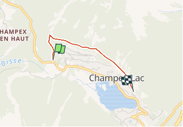
Ruta Senderismo de 1,8 km a descubrir en Vallés, Entremont, Orsières. Esta ruta ha sido propuesta por verbier.
Descripción
Randonnée à portée de tout le monde.
Le départ se trouve au milieu du parking de Téléchampex sur la droite et est signalé par un panneau jaune " Sentier d''Adray"
Elle débute par une petite montée pour redescendre à flanc coteau et arriver au centre de la station.
Localización
País:
Switzerland
Región :
Vallés
Departamento/provincia :
Entremont
Municipio :
Orsières
Localidad:
Unknown
Salida:(Dec)
Salida:(UTM)
353436 ; 5099421 (32T) N.
Comentarios
Excursiones cerca
![Excursión A pie Orsières - Chemins pédestre de montagne, commune d'Orsières - Photo](https://media.geolcdn.com/t/375/260/6dfeee0d-887b-4c9c-aefd-3dcd0ea22569.jpeg&format=jpg&maxdim=2)
![A pie A pie](https://static1.geolcdn.com/sitytour/trail-icons/100.png)
Chemins pédestre de montagne, commune d'Orsières
A pie
Fácil
Orsières,
Vallés,
Entremont,
Switzerland
![](/images/other/stat-length.png)
5,6 km | 8,8 km-effort
1h 59min
![](https://static1.geolcdn.com/siteimages/upload/files/16400158638029165_repeat_loop_refresh_sync_direction_icon.png)
No
![Excursión A pie Orsières - sentier du Devin - Photo](https://media.geolcdn.com/t/375/260/1486fc85-352e-404e-b600-0f3d7bac1924.jpeg&format=jpg&maxdim=2)
![A pie A pie](https://static1.geolcdn.com/sitytour/trail-icons/100.png)
sentier du Devin
A pie
Fácil
Orsières,
Vallés,
Entremont,
Switzerland
![](/images/other/stat-length.png)
3,9 km | 6,7 km-effort
1h 31min
![](https://static1.geolcdn.com/siteimages/upload/files/16400158638029165_repeat_loop_refresh_sync_direction_icon.png)
Sí
![Excursión A pie Orsières - Chemins pédestre, commune d'Orsières - Photo](https://media.geolcdn.com/t/375/260/70edd484-9073-4e02-96d0-3d17425bab34.jpeg&format=jpg&maxdim=2)
![A pie A pie](https://static1.geolcdn.com/sitytour/trail-icons/100.png)
Chemins pédestre, commune d'Orsières
A pie
Fácil
Orsières,
Vallés,
Entremont,
Switzerland
![](/images/other/stat-length.png)
5,4 km | 14,1 km-effort
3h 12min
![](https://static1.geolcdn.com/siteimages/upload/files/16400158638029165_repeat_loop_refresh_sync_direction_icon.png)
No
![Excursión A pie Bovernier - Chemins pédestre de montagne, région Entremont - Photo](https://media.geolcdn.com/t/375/260/8965cd81-5f88-4628-9726-209c4b98c789.jpeg&format=jpg&maxdim=2)
![A pie A pie](https://static1.geolcdn.com/sitytour/trail-icons/100.png)
Chemins pédestre de montagne, région Entremont
A pie
Medio
Bovernier,
Vallés,
Martigny,
Switzerland
![](/images/other/stat-length.png)
6,9 km | 22 km-effort
4h 54min
![](https://static1.geolcdn.com/siteimages/upload/files/16400158638029165_repeat_loop_refresh_sync_direction_icon.png)
No
![Excursión Senderismo Liddes - Combe de l’A - Photo](https://media.geolcdn.com/t/375/260/80b3ab05-1db2-4115-987f-2856a50ccafd.jpg&format=jpg&maxdim=2)
![Senderismo Senderismo](https://static1.geolcdn.com/sitytour/trail-icons/101.png)
Combe de l’A
Senderismo
Medio
Liddes,
Vallés,
Entremont,
Switzerland
![](/images/other/stat-length.png)
6,8 km | 12 km-effort
3h 27min
![](https://static1.geolcdn.com/siteimages/upload/files/16400158638029165_repeat_loop_refresh_sync_direction_icon.png)
No
![Excursión A pie Orsières - Raccard du blé - Photo](https://media.geolcdn.com/t/375/260/e3af305e-4edc-4919-bcad-22d8b69ac232.jpeg&format=jpg&maxdim=2)
![A pie A pie](https://static1.geolcdn.com/sitytour/trail-icons/100.png)
Raccard du blé
A pie
Fácil
Orsières,
Vallés,
Entremont,
Switzerland
![](/images/other/stat-length.png)
7,9 km | 13,7 km-effort
3h 6min
![](https://static1.geolcdn.com/siteimages/upload/files/16400158638029165_repeat_loop_refresh_sync_direction_icon.png)
Sí
![Excursión Senderismo Orsières - TMB 08 - Relais d'Arpette -> Trient - Photo](https://media.geolcdn.com/t/375/260/879d1358-40ae-4393-aa0f-3cd2dbd6e081.jpg&format=jpg&maxdim=2)
![Senderismo Senderismo](https://static1.geolcdn.com/sitytour/trail-icons/101.png)
TMB 08 - Relais d'Arpette -> Trient
Senderismo
Difícil
Orsières,
Vallés,
Entremont,
Switzerland
![](/images/other/stat-length.png)
17 km | 28 km-effort
6h 39min
![](https://static1.geolcdn.com/siteimages/upload/files/16400158638029165_repeat_loop_refresh_sync_direction_icon.png)
No
![Excursión Raquetas de nieve Orsières - Champex Lac - La Breya - Champex Lac - Photo](https://media.geolcdn.com/t/375/260/6555df26-5e72-41d3-9ea4-2761199f667f.jpg&format=jpg&maxdim=2)
![Raquetas de nieve Raquetas de nieve](https://static1.geolcdn.com/sitytour/trail-icons/504.png)
Champex Lac - La Breya - Champex Lac
Raquetas de nieve
Medio
Orsières,
Vallés,
Entremont,
Switzerland
![](/images/other/stat-length.png)
8,8 km | 18,2 km-effort
3h 1min
![](https://static1.geolcdn.com/siteimages/upload/files/16400158638029165_repeat_loop_refresh_sync_direction_icon.png)
Sí
![Excursión Senderismo Orsières - CMX ZRMT Étape 2 Champex Cabane de Mille - Photo](https://media.geolcdn.com/t/375/260/ext.jpg?maxdim=2&url=https%3A%2F%2Fservices.sitytrail.com%2FGeolivesWS%2FDownloadMedia.ashx%3FTrailID%3D635928%26Media%3Dfix__20160914135625.jpg)
![Senderismo Senderismo](https://static1.geolcdn.com/sitytour/trail-icons/101.png)
CMX ZRMT Étape 2 Champex Cabane de Mille
Senderismo
Medio
Orsières,
Vallés,
Entremont,
Switzerland
![](/images/other/stat-length.png)
17,9 km | 38 km-effort
7h 15min
![](https://static1.geolcdn.com/siteimages/upload/files/16400158638029165_repeat_loop_refresh_sync_direction_icon.png)
No