![](/images/other/stat-length.png)
![Excursión Senderismo Orsières - TMB Étape 5 : Gite de La Peule au Relais d'Arpette - Photo](https://media.geolcdn.com/t/1900/400/ext.pjpeg?maxdim=2&url=https%3A%2F%2Fstatic1.geolcdn.com%2Fsiteimages%2Fupload%2Ffiles%2F1553511878bg_sport_marche.png)
TMB Étape 5 : Gite de La Peule au Relais d'Arpette
Timothée ZARAGORI
Usuario
![Longitud](/images/other/stat-length.png)
Longitud
22 km
![Altitud máxima](https://static1.geolcdn.com/siteimages/upload/files/1508320355ic_sort_altitude_max_24dp.png)
Altitud máxima
2071 m
![Desnivel positivo](https://static1.geolcdn.com/siteimages/upload/files/1508320355ic_sort_den_pos_24dp.png)
Desnivel positivo
754 m
![Km-Effort](/images/other/stat-length.png)
Km-Effort
34 km
![Altitud mínima](https://static1.geolcdn.com/siteimages/upload/files/1508320355ic_sort_altitude_min_24dp.png)
Altitud mínima
1048 m
![Desnivel negativo](https://static1.geolcdn.com/siteimages/upload/files/1508320355ic_sort_den_neg_24dp.png)
Desnivel negativo
1192 m
![Boucle](https://static1.geolcdn.com/siteimages/upload/files/16400158638029165_repeat_loop_refresh_sync_direction_icon.png)
Boucle
No
Fecha de creación :
2024-08-04 20:10:56.68
Última modificación :
2024-08-04 21:19:42.283
![Senderismo](https://static1.geolcdn.com/sitytour/trail-icons/101.png)
7h40
Dificultad : Muy difícil
![Escanee este código QR para abrir la excursión en la aplicación SityTrail](https://capi.geolives.com/qq0zvz2zws4bq2lad0pu/sitytour/trails/4144733/qr.png?size=200)
Aplicación GPS de excursión GRATIS
A propósito
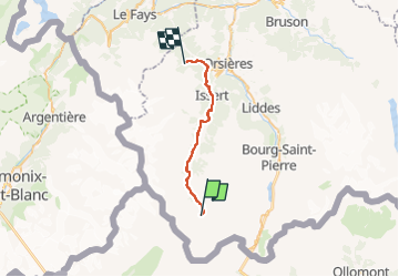
Ruta Senderismo de 22 km a descubrir en Vallés, Entremont, Orsières. Esta ruta ha sido propuesta por Timothée ZARAGORI.
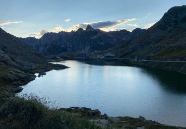
Descripción
Passage par Ferret
https://fr.wikiloc.com/itineraires-randonnee/tmb7-ferret-a-relais-darpette-42296562
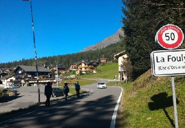
➡️ La Fouly
➡️ Praz-le-Fort
➡️ Champex-Lac
➡️ Champex Embranchement
➡️ Relais d’Arpette
Localización
País:
Switzerland
Región :
Vallés
Departamento/provincia :
Entremont
Municipio :
Orsières
Localidad:
Unknown
Salida:(Dec)
Salida:(UTM)
353596 ; 5084514 (32T) N.
Comentarios
Excursiones cerca
![Excursión Senderismo Bourg-Saint-Pierre - st. Bernard - Photo](https://media.geolcdn.com/t/375/260/ext.jpg?maxdim=2&url=https%3A%2F%2Fservices.sitytrail.com%2FGeolivesWS%2FDownloadMedia.ashx%3FTrailID%3D210266%26Media%3Dfix__20130804173737.jpg)
![Senderismo Senderismo](https://static1.geolcdn.com/sitytour/trail-icons/101.png)
st. Bernard
Senderismo
Muy fácil
(2)
Bourg-Saint-Pierre,
Vallés,
Entremont,
Switzerland
![](/images/other/stat-length.png)
44 km | 116 km-effort
6h 17min
![](https://static1.geolcdn.com/siteimages/upload/files/16400158638029165_repeat_loop_refresh_sync_direction_icon.png)
No
![Excursión A pie Bourg-Saint-Pierre - Chemins pédestres, région St-Bernard - Photo](https://media.geolcdn.com/t/375/260/3ecb502d-aa39-43c7-b4fa-d2f145975573.jpeg&format=jpg&maxdim=2)
![A pie A pie](https://static1.geolcdn.com/sitytour/trail-icons/100.png)
Chemins pédestres, région St-Bernard
A pie
Fácil
Bourg-Saint-Pierre,
Vallés,
Entremont,
Switzerland
![](/images/other/stat-length.png)
8,6 km | 18,8 km-effort
4h 15min
![](https://static1.geolcdn.com/siteimages/upload/files/16400158638029165_repeat_loop_refresh_sync_direction_icon.png)
No
![Excursión A pie Bourg-Saint-Pierre - Via Alpina Red R117 - Photo](https://media.geolcdn.com/t/375/260/13ce668d-e692-4cf0-91fa-ed93365ce626.jpeg&format=jpg&maxdim=2)
![A pie A pie](https://static1.geolcdn.com/sitytour/trail-icons/100.png)
Via Alpina Red R117
A pie
Muy difícil
Bourg-Saint-Pierre,
Vallés,
Entremont,
Switzerland
![](/images/other/stat-length.png)
27 km | 46 km-effort
10h 25min
![](https://static1.geolcdn.com/siteimages/upload/files/16400158638029165_repeat_loop_refresh_sync_direction_icon.png)
No
![Excursión A pie Orsières - Trail Verbier St-Bernard - Traversée - Photo](https://media.geolcdn.com/t/375/260/dafbc912-1c22-4e42-aaf9-5568981fc800.jpeg&format=jpg&maxdim=2)
![A pie A pie](https://static1.geolcdn.com/sitytour/trail-icons/100.png)
Trail Verbier St-Bernard - Traversée
A pie
Muy difícil
Orsières,
Vallés,
Entremont,
Switzerland
![](/images/other/stat-length.png)
37 km | 70 km-effort
15h 47min
![](https://static1.geolcdn.com/siteimages/upload/files/16400158638029165_repeat_loop_refresh_sync_direction_icon.png)
No
![Excursión A pie Orsières - Sentier des Bergers - Photo](https://media.geolcdn.com/t/375/260/a8cdee56-d9cf-46a0-9048-05577c82dfc2.jpeg&format=jpg&maxdim=2)
![A pie A pie](https://static1.geolcdn.com/sitytour/trail-icons/100.png)
Sentier des Bergers
A pie
Fácil
Orsières,
Vallés,
Entremont,
Switzerland
![](/images/other/stat-length.png)
4,8 km | 9,2 km-effort
2h 5min
![](https://static1.geolcdn.com/siteimages/upload/files/16400158638029165_repeat_loop_refresh_sync_direction_icon.png)
No
![Excursión Senderismo Orsières - La Fouly Ferret - Photo](https://media.geolcdn.com/t/375/260/9ccbcdc3-96f7-4967-963b-9422de80e17a.jpg&format=jpg&maxdim=2)
![Senderismo Senderismo](https://static1.geolcdn.com/sitytour/trail-icons/101.png)
La Fouly Ferret
Senderismo
Medio
Orsières,
Vallés,
Entremont,
Switzerland
![](/images/other/stat-length.png)
6,4 km | 9,7 km-effort
2h 58min
![](https://static1.geolcdn.com/siteimages/upload/files/16400158638029165_repeat_loop_refresh_sync_direction_icon.png)
Sí
![Excursión Senderismo Bourg-Saint-Pierre - St Bernard - Photo](https://media.geolcdn.com/t/375/260/1947af24-c4d5-4de6-a636-7c1ee087fc5c.jpg&format=jpg&maxdim=2)
![Senderismo Senderismo](https://static1.geolcdn.com/sitytour/trail-icons/101.png)
St Bernard
Senderismo
Medio
Bourg-Saint-Pierre,
Vallés,
Entremont,
Switzerland
![](/images/other/stat-length.png)
4,7 km | 8,1 km-effort
2h 49min
![](https://static1.geolcdn.com/siteimages/upload/files/16400158638029165_repeat_loop_refresh_sync_direction_icon.png)
Sí
![Excursión Senderismo Courmayeur - TMB J4 Ref.ELENA - COURMAYEUR - Photo](https://media.geolcdn.com/t/375/260/ext.jpg?maxdim=2&url=https%3A%2F%2Fservices.sitytrail.com%2FGeolivesWS%2FDownloadMedia.ashx%3FTrailID%3D594957%26Media%3Dfix__20160706110719.jpg)
![Senderismo Senderismo](https://static1.geolcdn.com/sitytour/trail-icons/101.png)
TMB J4 Ref.ELENA - COURMAYEUR
Senderismo
Medio
Courmayeur,
Valle de Aosta,
Desconocido,
Italy
![](/images/other/stat-length.png)
13,5 km | 22 km-effort
4h 18min
![](https://static1.geolcdn.com/siteimages/upload/files/16400158638029165_repeat_loop_refresh_sync_direction_icon.png)
No
![Excursión Senderismo Courmayeur - TMB day 4 - Photo](https://media.geolcdn.com/t/375/260/ext.jpg?maxdim=2&url=https%3A%2F%2Fservices.sitytrail.com%2FGeolivesWS%2FDownloadMedia.ashx%3FTrailID%3D477599%26Media%3Dfix__20150924164207.jpg)
![Senderismo Senderismo](https://static1.geolcdn.com/sitytour/trail-icons/101.png)
TMB day 4
Senderismo
Medio
Courmayeur,
Valle de Aosta,
Desconocido,
Italy
![](/images/other/stat-length.png)
16,6 km | 27 km-effort
5h 37min
![](https://static1.geolcdn.com/siteimages/upload/files/16400158638029165_repeat_loop_refresh_sync_direction_icon.png)
No