![](/images/other/stat-length.png)
![Excursión Senderismo Chichilianne - 14923554-Tour du Mont Aiguille - Photo](https://media.geolcdn.com/t/1900/400/ext.pjpeg?maxdim=2&url=https%3A%2F%2Fstatic1.geolcdn.com%2Fsiteimages%2Fupload%2Ffiles%2F1553511878bg_sport_marche.png)
14923554-Tour du Mont Aiguille
Maryma
Usuario
![Longitud](/images/other/stat-length.png)
![Altitud máxima](https://static1.geolcdn.com/siteimages/upload/files/1508320355ic_sort_altitude_max_24dp.png)
![Desnivel positivo](https://static1.geolcdn.com/siteimages/upload/files/1508320355ic_sort_den_pos_24dp.png)
![Km-Effort](/images/other/stat-length.png)
![Altitud mínima](https://static1.geolcdn.com/siteimages/upload/files/1508320355ic_sort_altitude_min_24dp.png)
![Desnivel negativo](https://static1.geolcdn.com/siteimages/upload/files/1508320355ic_sort_den_neg_24dp.png)
![Boucle](https://static1.geolcdn.com/siteimages/upload/files/16400158638029165_repeat_loop_refresh_sync_direction_icon.png)
![Senderismo](https://static1.geolcdn.com/sitytour/trail-icons/101.png)
7h27
Dificultad : Muy difícil
![Escanee este código QR para abrir la excursión en la aplicación SityTrail](https://capi.geolives.com/qq0zvz2zws4bq2lad0pu/sitytour/trails/3962815/qr.png?size=200)
Aplicación GPS de excursión GRATIS
A propósito
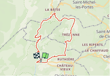
Ruta Senderismo de 17,7 km a descubrir en Auvergne-Rhône-Alpes, Isère, Chichilianne. Esta ruta ha sido propuesta por Maryma.
Descripción
Le tour du Mont-Aiguille est une très belle et longue randonnée qui permettra d'observer cette aiguille de calcaire sous tous ses angles. La diversité des paysages rencontrés est étonnante !
Tour du Mont-Aiguille, superbe paquebot, isolé de la chaîne principale du Vercors. Il se fait admirer de tous et notamment sa majestueuse proue qui domine les villages de Trézanne (nous y passerons) et de Richardière (notre point de départ). De nombreux passages remarquables : marne ravinées, torrent des ruines, camp de Font-Rousse, col de l'Aupet... C'est une très belle et longue randonnée qui vous permettra d'observer cette aiguille de calcaire sous tous ses angles.
La randonnée est longue et nécessite une bonne condition physique.
Localización
Comentarios
Excursiones cerca
![Excursión Senderismo Saint-Michel-les-Portes - Grand Ceymont par la face Sud - Photo](https://media.geolcdn.com/t/375/260/d58be866-4722-407f-9e9c-e7428ea96660.jpg&format=jpg&maxdim=2)
![Senderismo Senderismo](https://static1.geolcdn.com/sitytour/trail-icons/101.png)
Senderismo
![](/images/other/stat-length.png)
![](https://static1.geolcdn.com/siteimages/upload/files/16400158638029165_repeat_loop_refresh_sync_direction_icon.png)
![Excursión Senderismo Chichilianne - Le Platary - Photo](https://media.geolcdn.com/t/375/260/ext.jpg?maxdim=2&url=https%3A%2F%2Fservices.sitytrail.com%2FGeolivesWS%2FDownloadMedia.ashx%3FTrailID%3D836793%26Media%3Dfix__20170928142121.jpg)
![Senderismo Senderismo](https://static1.geolcdn.com/sitytour/trail-icons/101.png)
Senderismo
![](/images/other/stat-length.png)
![](https://static1.geolcdn.com/siteimages/upload/files/16400158638029165_repeat_loop_refresh_sync_direction_icon.png)
![Excursión Senderismo Chichilianne - La Fontaine Pourrie - Hauts Plateaux Sud du Vercors - Photo](https://media.geolcdn.com/t/375/260/ext.jpg?maxdim=2&url=https%3A%2F%2Fservices.sitytrail.com%2FGeolivesWS%2FDownloadMedia.ashx%3FTrailID%3D105613%26Media%3D9383_1.jpg)
![Senderismo Senderismo](https://static1.geolcdn.com/sitytour/trail-icons/101.png)
Senderismo
![](/images/other/stat-length.png)
![](https://static1.geolcdn.com/siteimages/upload/files/16400158638029165_repeat_loop_refresh_sync_direction_icon.png)
![Excursión Senderismo Gresse-en-Vercors - traversée Sud nord du Grand Veymont - Photo](https://media.geolcdn.com/t/375/260/3004a1b5-ea0f-48e3-8863-72e77652ad4d.jpg&format=jpg&maxdim=2)
![Senderismo Senderismo](https://static1.geolcdn.com/sitytour/trail-icons/101.png)
Senderismo
![](/images/other/stat-length.png)
![](https://static1.geolcdn.com/siteimages/upload/files/16400158638029165_repeat_loop_refresh_sync_direction_icon.png)
![Excursión Senderismo Saint-Michel-les-Portes - Tour du Mont Aiguille - Photo](https://media.geolcdn.com/t/375/260/13641da4-549e-49b9-8e23-d4a17f7e4345.jpg&format=jpg&maxdim=2)
![Senderismo Senderismo](https://static1.geolcdn.com/sitytour/trail-icons/101.png)
Senderismo
![](/images/other/stat-length.png)
![](https://static1.geolcdn.com/siteimages/upload/files/16400158638029165_repeat_loop_refresh_sync_direction_icon.png)
![Excursión Raquetas de nieve Chichilianne - chichilianne archiane - Photo](https://media.geolcdn.com/t/375/260/ext.jpg?maxdim=2&url=https%3A%2F%2Fstatic1.geolcdn.com%2Fsiteimages%2Fupload%2Ffiles%2F1524743153raquette.jpg)
![Raquetas de nieve Raquetas de nieve](https://static1.geolcdn.com/sitytour/trail-icons/504.png)
Raquetas de nieve
![](/images/other/stat-length.png)
![](https://static1.geolcdn.com/siteimages/upload/files/16400158638029165_repeat_loop_refresh_sync_direction_icon.png)
![Excursión Senderismo Saint-Michel-les-Portes - Pas de Bachassons et de la Selle - Photo](https://media.geolcdn.com/t/375/260/10e42988-cabf-4bc0-8c6b-1118178d695b.jpg&format=jpg&maxdim=2)
![Senderismo Senderismo](https://static1.geolcdn.com/sitytour/trail-icons/101.png)
Senderismo
![](/images/other/stat-length.png)
![](https://static1.geolcdn.com/siteimages/upload/files/16400158638029165_repeat_loop_refresh_sync_direction_icon.png)
![Excursión Senderismo Chichilianne - Diois 2024 1ère journée - Photo](https://media.geolcdn.com/t/375/260/b1054cee-df49-45a8-83b3-a4a0caa6aa04.jpg&format=jpg&maxdim=2)
![Senderismo Senderismo](https://static1.geolcdn.com/sitytour/trail-icons/101.png)
Senderismo
![](/images/other/stat-length.png)
![](https://static1.geolcdn.com/siteimages/upload/files/16400158638029165_repeat_loop_refresh_sync_direction_icon.png)
![Excursión Senderismo Gresse-en-Vercors - Pas des Baschassons - Carrière romaine - Pas de la Selle - Photo](https://media.geolcdn.com/t/375/260/56b0bd40-9412-42bf-9504-9a813d0bd429.jpg&format=jpg&maxdim=2)
![Senderismo Senderismo](https://static1.geolcdn.com/sitytour/trail-icons/101.png)
Senderismo
![](/images/other/stat-length.png)
![](https://static1.geolcdn.com/siteimages/upload/files/16400158638029165_repeat_loop_refresh_sync_direction_icon.png)