![](/images/other/stat-length.png)
![Excursión Senderismo Lapoutroie - 2 De Lapoutroie à Fréland par le col de Chamont - Photo](https://media.geolcdn.com/t/1900/400/ext.pjpeg?maxdim=2&url=https%3A%2F%2Fstatic1.geolcdn.com%2Fsiteimages%2Fupload%2Ffiles%2F1553511878bg_sport_marche.png)
2 De Lapoutroie à Fréland par le col de Chamont
scaillet
Usuario
![Longitud](/images/other/stat-length.png)
Longitud
11,3 km
![Altitud máxima](https://static1.geolcdn.com/siteimages/upload/files/1508320355ic_sort_altitude_max_24dp.png)
Altitud máxima
681 m
![Desnivel positivo](https://static1.geolcdn.com/siteimages/upload/files/1508320355ic_sort_den_pos_24dp.png)
Desnivel positivo
453 m
![Km-Effort](/images/other/stat-length.png)
Km-Effort
17,3 km
![Altitud mínima](https://static1.geolcdn.com/siteimages/upload/files/1508320355ic_sort_altitude_min_24dp.png)
Altitud mínima
417 m
![Desnivel negativo](https://static1.geolcdn.com/siteimages/upload/files/1508320355ic_sort_den_neg_24dp.png)
Desnivel negativo
453 m
![Boucle](https://static1.geolcdn.com/siteimages/upload/files/16400158638029165_repeat_loop_refresh_sync_direction_icon.png)
Boucle
Sí
Fecha de creación :
2023-10-25 09:11:25.084
Última modificación :
2023-10-25 09:22:33.543
![Senderismo](https://static1.geolcdn.com/sitytour/trail-icons/101.png)
3h56
Dificultad : Difícil
![Escanee este código QR para abrir la excursión en la aplicación SityTrail](https://capi.geolives.com/qq0zvz2zws4bq2lad0pu/sitytour/trails/3849920/qr.png?size=200)
Aplicación GPS de excursión GRATIS
A propósito
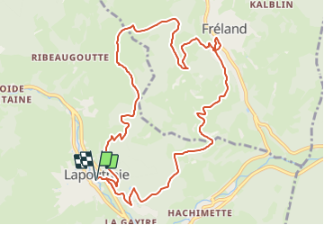
Ruta Senderismo de 11,3 km a descubrir en Gran Este, Alto Rin, Lapoutroie. Esta ruta ha sido propuesta por scaillet.
Descripción
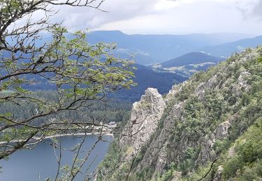
Un départ en pente raide, quelques passages en forêt, mais surtout de belles vues sur Lapoutroie et le val d'Orbey, le Brézouard et la Tête des Faux, ainsi que sur Fréland et le massif du Kaelblin. musee fermé
Localización
País:
France
Región :
Gran Este
Departamento/provincia :
Alto Rin
Municipio :
Lapoutroie
Localidad:
Unknown
Salida:(Dec)
Salida:(UTM)
363922 ; 5334886 (32U) N.
Comentarios
Excursiones cerca
![Excursión Senderismo Lapoutroie - 2012-06-16 Marche aux Alisiers Orbey - Photo](https://media.geolcdn.com/t/375/260/ext.jpg?maxdim=2&url=https%3A%2F%2Fstatic1.geolcdn.com%2Fsiteimages%2Fupload%2Ffiles%2F1553511878bg_sport_marche.png)
![Senderismo Senderismo](https://static1.geolcdn.com/sitytour/trail-icons/101.png)
2012-06-16 Marche aux Alisiers Orbey
Senderismo
Fácil
(2)
Lapoutroie,
Gran Este,
Alto Rin,
France
![](/images/other/stat-length.png)
11,1 km | 16,6 km-effort
2h 49min
![](https://static1.geolcdn.com/siteimages/upload/files/16400158638029165_repeat_loop_refresh_sync_direction_icon.png)
Sí
![Excursión Senderismo Le Bonhomme - Le Bonhomme - Circuit du village - Photo](https://media.geolcdn.com/t/375/260/ext.jpg?maxdim=2&url=https%3A%2F%2Fstatic1.geolcdn.com%2Fsiteimages%2Fupload%2Ffiles%2F1553511878bg_sport_marche.png)
![Senderismo Senderismo](https://static1.geolcdn.com/sitytour/trail-icons/101.png)
Le Bonhomme - Circuit du village
Senderismo
Fácil
(1)
Le Bonhomme,
Gran Este,
Alto Rin,
France
![](/images/other/stat-length.png)
3 km | 5,3 km-effort
1h 30min
![](https://static1.geolcdn.com/siteimages/upload/files/16400158638029165_repeat_loop_refresh_sync_direction_icon.png)
Sí
![Excursión Senderismo Sainte-Marie-aux-Mines - 2021-02-14 Marche Bagenelles Brezouard Fuste de Etoile - Photo](https://media.geolcdn.com/t/375/260/79d211e6-ae5a-4d3f-8163-d2103469db38.jpg&format=jpg&maxdim=2)
![Senderismo Senderismo](https://static1.geolcdn.com/sitytour/trail-icons/101.png)
2021-02-14 Marche Bagenelles Brezouard Fuste de Etoile
Senderismo
Muy difícil
Sainte-Marie-aux-Mines,
Gran Este,
Alto Rin,
France
![](/images/other/stat-length.png)
17,1 km | 27 km-effort
6h 6min
![](https://static1.geolcdn.com/siteimages/upload/files/16400158638029165_repeat_loop_refresh_sync_direction_icon.png)
Sí
![Excursión Senderismo Lapoutroie - 2020-07-19 Marche Étang du Devin Col Calvaire Tête des Faux - Photo](https://media.geolcdn.com/t/375/260/615f03a1-e6aa-4706-9550-1df8400dcef8.jpg&format=jpg&maxdim=2)
![Senderismo Senderismo](https://static1.geolcdn.com/sitytour/trail-icons/101.png)
2020-07-19 Marche Étang du Devin Col Calvaire Tête des Faux
Senderismo
Muy fácil
Lapoutroie,
Gran Este,
Alto Rin,
France
![](/images/other/stat-length.png)
14,2 km | 22 km-effort
3h 27min
![](https://static1.geolcdn.com/siteimages/upload/files/16400158638029165_repeat_loop_refresh_sync_direction_icon.png)
Sí
![Excursión Senderismo Orbey - Orbey-Labaroche - Photo](https://media.geolcdn.com/t/375/260/ext.jpg?maxdim=2&url=https%3A%2F%2Fstatic1.geolcdn.com%2Fsiteimages%2Fupload%2Ffiles%2F1553511878bg_sport_marche.png)
![Senderismo Senderismo](https://static1.geolcdn.com/sitytour/trail-icons/101.png)
Orbey-Labaroche
Senderismo
Fácil
(1)
Orbey,
Gran Este,
Alto Rin,
France
![](/images/other/stat-length.png)
13,7 km | 21 km-effort
4h 17min
![](https://static1.geolcdn.com/siteimages/upload/files/16400158638029165_repeat_loop_refresh_sync_direction_icon.png)
Sí
![Excursión Bici de montaña Orbey - Welche E Bike Tour 2024 - Photo](https://media.geolcdn.com/t/375/260/8d9a6867-e2f3-410d-af18-d6097d6fcf56.jpg&format=jpg&maxdim=2)
![Bici de montaña Bici de montaña](https://static1.geolcdn.com/sitytour/trail-icons/202.png)
Welche E Bike Tour 2024
Bici de montaña
Medio
Orbey,
Gran Este,
Alto Rin,
France
![](/images/other/stat-length.png)
35 km | 51 km-effort
2h 17min
![](https://static1.geolcdn.com/siteimages/upload/files/16400158638029165_repeat_loop_refresh_sync_direction_icon.png)
Sí
![Excursión Senderismo Orbey - CVL - Rando 16/08/2024 - Autour d'Orbey - Photo](https://media.geolcdn.com/t/375/260/c3c2f692-9f32-4b12-b704-0572b0ebbaa3.jpg&format=jpg&maxdim=2)
![Senderismo Senderismo](https://static1.geolcdn.com/sitytour/trail-icons/101.png)
CVL - Rando 16/08/2024 - Autour d'Orbey
Senderismo
Difícil
Orbey,
Gran Este,
Alto Rin,
France
![](/images/other/stat-length.png)
9 km | 12,8 km-effort
3h 8min
![](https://static1.geolcdn.com/siteimages/upload/files/16400158638029165_repeat_loop_refresh_sync_direction_icon.png)
Sí
![Excursión Senderismo Lapoutroie - 2024-07-24_18h02m57_230112363 - Photo](https://media.geolcdn.com/t/375/260/5afb5f6f-bf25-4db1-8c88-6112e557e3ed.jpg&format=jpg&maxdim=2)
![Senderismo Senderismo](https://static1.geolcdn.com/sitytour/trail-icons/101.png)
2024-07-24_18h02m57_230112363
Senderismo
Difícil
Lapoutroie,
Gran Este,
Alto Rin,
France
![](/images/other/stat-length.png)
10,3 km | 17,2 km-effort
3h 54min
![](https://static1.geolcdn.com/siteimages/upload/files/16400158638029165_repeat_loop_refresh_sync_direction_icon.png)
Sí
![Excursión Senderismo Orbey - orbey lac noir et lac blanc - Photo](https://media.geolcdn.com/t/375/260/e26bc43e-8690-47b3-aeab-3b33ddc4ff5e.jpg&format=jpg&maxdim=2)
![Senderismo Senderismo](https://static1.geolcdn.com/sitytour/trail-icons/101.png)
orbey lac noir et lac blanc
Senderismo
Difícil
(1)
Orbey,
Gran Este,
Alto Rin,
France
![](/images/other/stat-length.png)
10 km | 15,3 km-effort
4h 34min
![](https://static1.geolcdn.com/siteimages/upload/files/16400158638029165_repeat_loop_refresh_sync_direction_icon.png)
No