![](/images/other/stat-length.png)
![Excursión Senderismo Entraunes - Estenc col de la boucharde - Photo](https://media.geolcdn.com/t/1900/400/ext.pjpeg?maxdim=2&url=https%3A%2F%2Fmedia.geolcdn.com%2Ff%2Fb25034d6-9dcf-4e2a-b862-fc4a53eaef0b.jpg)
Estenc col de la boucharde
Marchopier
Usuario
![Longitud](/images/other/stat-length.png)
![Altitud máxima](https://static1.geolcdn.com/siteimages/upload/files/1508320355ic_sort_altitude_max_24dp.png)
![Desnivel positivo](https://static1.geolcdn.com/siteimages/upload/files/1508320355ic_sort_den_pos_24dp.png)
![Km-Effort](/images/other/stat-length.png)
![Altitud mínima](https://static1.geolcdn.com/siteimages/upload/files/1508320355ic_sort_altitude_min_24dp.png)
![Desnivel negativo](https://static1.geolcdn.com/siteimages/upload/files/1508320355ic_sort_den_neg_24dp.png)
![Boucle](https://static1.geolcdn.com/siteimages/upload/files/16400158638029165_repeat_loop_refresh_sync_direction_icon.png)
![Senderismo](https://static1.geolcdn.com/sitytour/trail-icons/101.png)
7h00
Dificultad : Medio
![Escanee este código QR para abrir la excursión en la aplicación SityTrail](https://capi.geolives.com/qq0zvz2zws4bq2lad0pu/sitytour/trails/3279502/qr.png?size=200)
Aplicación GPS de excursión GRATIS
A propósito
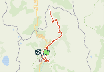
Ruta Senderismo de 17,7 km a descubrir en Provenza-Alpes-Costa Azul, Alpes Marítimos, Entraunes. Esta ruta ha sido propuesta por Marchopier.
Descripción
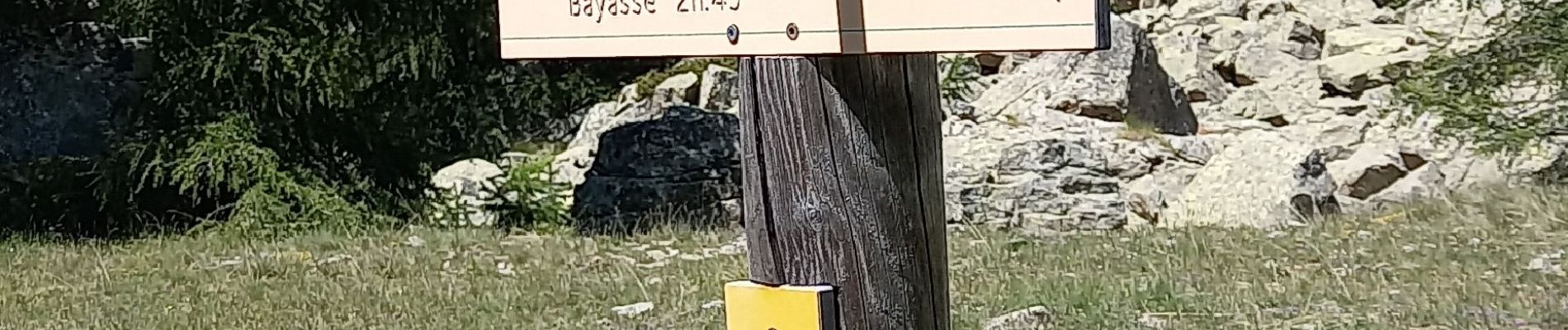
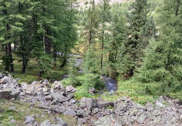
Depuis Estenc passage sur le ruisseau de Sanguinière ,traversée de la forët et des plairies fleuries ,alternant avec les grès d'Annot, jusqu'aux cabanes ,puis montée jusqu'au Col de La Boucharde.
Progression lente pour identifier et mémoriser,ou presque, les multitudes de fleurs qui s'offrent à nous.
Plein les yeux mais surtout aucune cueillette ,interdite dans le Parc du Mercantour
Localización
Comentarios
Excursiones cerca
![Excursión Senderismo Uvernet-Fours - Mercantour Le Cimet 3020 m - Photo](https://media.geolcdn.com/t/375/260/ext.jpg?maxdim=2&url=https%3A%2F%2Fservices.sitytrail.com%2FGeolivesWS%2FDownloadMedia.ashx%3FTrailID%3D224622%26Media%3D20130930134741.jpg)
![Senderismo Senderismo](https://static1.geolcdn.com/sitytour/trail-icons/101.png)
Senderismo
![](/images/other/stat-length.png)
![](https://static1.geolcdn.com/siteimages/upload/files/16400158638029165_repeat_loop_refresh_sync_direction_icon.png)
![Excursión A pie Entraunes - Circuit des Lacs - Photo](https://media.geolcdn.com/t/375/260/ext.jpg?maxdim=2&url=https%3A%2F%2Fmedia.geolcdn.com%2Ff%2Fa896acce-5a5d-4d38-a76c-8521eb37107d.jpeg)
![A pie A pie](https://static1.geolcdn.com/sitytour/trail-icons/100.png)
A pie
![](/images/other/stat-length.png)
![](https://static1.geolcdn.com/siteimages/upload/files/16400158638029165_repeat_loop_refresh_sync_direction_icon.png)
![Excursión A pie Entraunes - Col de la Boucharde - Photo](https://media.geolcdn.com/t/375/260/ext.jpg?maxdim=2&url=https%3A%2F%2Fmedia.geolcdn.com%2Ff%2F3f8fb4f1-6b5f-4291-a48f-766ff65dc022.jpeg)
![A pie A pie](https://static1.geolcdn.com/sitytour/trail-icons/100.png)
A pie
![](/images/other/stat-length.png)
![](https://static1.geolcdn.com/siteimages/upload/files/16400158638029165_repeat_loop_refresh_sync_direction_icon.png)
![Excursión A pie Entraunes - Tête de la Boulière - Photo](https://media.geolcdn.com/t/375/260/ext.jpg?maxdim=2&url=https%3A%2F%2Fmedia.geolcdn.com%2Ff%2F4b7ce69a-b9c1-4af6-a119-2b6bf9e9add8.jpeg)
![A pie A pie](https://static1.geolcdn.com/sitytour/trail-icons/100.png)
A pie
![](/images/other/stat-length.png)
![](https://static1.geolcdn.com/siteimages/upload/files/16400158638029165_repeat_loop_refresh_sync_direction_icon.png)
![Excursión Senderismo Allos - le mont Pelat et le lac du trou de l'aigle - Photo](https://media.geolcdn.com/t/375/260/ext.jpg?maxdim=2&url=https%3A%2F%2Fservices.sitytrail.com%2FGeolivesWS%2FDownloadMedia.ashx%3FTrailID%3D791325%26Media%3D36a05fdf-444e-4dea-af98-fa2a609b54f1.JPG)
![Senderismo Senderismo](https://static1.geolcdn.com/sitytour/trail-icons/101.png)
Senderismo
![](/images/other/stat-length.png)
![](https://static1.geolcdn.com/siteimages/upload/files/16400158638029165_repeat_loop_refresh_sync_direction_icon.png)
![Excursión Senderismo Allos - ALLOS. LAC D ALLOS. COL DE LACAYOLE .O - Photo](https://media.geolcdn.com/t/375/260/ext.jpg?maxdim=2&url=https%3A%2F%2Fmedia.geolcdn.com%2Ff%2Fdff6c4e7-81d7-4f55-8309-f016e1c29cdc.jpg)
![Senderismo Senderismo](https://static1.geolcdn.com/sitytour/trail-icons/101.png)
Senderismo
![](/images/other/stat-length.png)
![](https://static1.geolcdn.com/siteimages/upload/files/16400158638029165_repeat_loop_refresh_sync_direction_icon.png)
![Excursión Raquetas de nieve Entraunes - Pointe du Génépi - Photo](https://media.geolcdn.com/t/375/260/ext.jpg?maxdim=2&url=https%3A%2F%2Fmedia.geolcdn.com%2Ff%2F2c3e08c2-1c63-4808-93f2-8a68b684f182.jpg)
![Raquetas de nieve Raquetas de nieve](https://static1.geolcdn.com/sitytour/trail-icons/504.png)
Raquetas de nieve
![](/images/other/stat-length.png)
![](https://static1.geolcdn.com/siteimages/upload/files/16400158638029165_repeat_loop_refresh_sync_direction_icon.png)
![Excursión Senderismo Entraunes - Estenc rando 1 - Photo](https://media.geolcdn.com/t/375/260/ext.jpg?maxdim=2&url=https%3A%2F%2Fmedia.geolcdn.com%2Ff%2Facff3831-66b3-4d9b-9b8d-af19b845261d.jpg)
![Senderismo Senderismo](https://static1.geolcdn.com/sitytour/trail-icons/101.png)
Senderismo
![](/images/other/stat-length.png)
![](https://static1.geolcdn.com/siteimages/upload/files/16400158638029165_repeat_loop_refresh_sync_direction_icon.png)
![Excursión Senderismo Uvernet-Fours - LES LACS DE LA CAYOLLE - Photo](https://media.geolcdn.com/t/375/260/ext.jpg?maxdim=2&url=https%3A%2F%2Fmedia.geolcdn.com%2Ff%2F0280497a-997f-45dd-9f0a-a99605dc0d30.jpg)
![Senderismo Senderismo](https://static1.geolcdn.com/sitytour/trail-icons/101.png)
Senderismo
![](/images/other/stat-length.png)
![](https://static1.geolcdn.com/siteimages/upload/files/16400158638029165_repeat_loop_refresh_sync_direction_icon.png)