![](/images/other/stat-length.png)
![Excursión Senderismo Plateau-des-Petites-Roches - Hauts de Chartreuse - Photo](https://media.geolcdn.com/t/1900/400/ext.pjpeg?maxdim=2&url=https%3A%2F%2Fstatic1.geolcdn.com%2Fsiteimages%2Fupload%2Ffiles%2F1553511878bg_sport_marche.png)
Hauts de Chartreuse
jparet
Usuario
![Longitud](/images/other/stat-length.png)
Longitud
18 km
![Altitud máxima](https://static1.geolcdn.com/siteimages/upload/files/1508320355ic_sort_altitude_max_24dp.png)
Altitud máxima
1887 m
![Desnivel positivo](https://static1.geolcdn.com/siteimages/upload/files/1508320355ic_sort_den_pos_24dp.png)
Desnivel positivo
1298 m
![Km-Effort](/images/other/stat-length.png)
Km-Effort
35 km
![Altitud mínima](https://static1.geolcdn.com/siteimages/upload/files/1508320355ic_sort_altitude_min_24dp.png)
Altitud mínima
1067 m
![Desnivel negativo](https://static1.geolcdn.com/siteimages/upload/files/1508320355ic_sort_den_neg_24dp.png)
Desnivel negativo
1299 m
![Boucle](https://static1.geolcdn.com/siteimages/upload/files/16400158638029165_repeat_loop_refresh_sync_direction_icon.png)
Boucle
Sí
Fecha de creación :
2022-05-28 06:53:52.555
Última modificación :
2022-05-28 14:29:01.104
![Senderismo](https://static1.geolcdn.com/sitytour/trail-icons/101.png)
7h19
Dificultad : Difícil
![Escanee este código QR para abrir la excursión en la aplicación SityTrail](https://capi.geolives.com/qq0zvz2zws4bq2lad0pu/sitytour/trails/3260776/qr.png?size=200)
Aplicación GPS de excursión GRATIS
A propósito
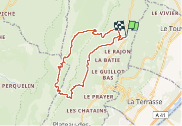
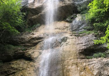
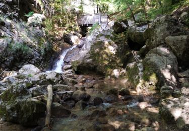
Ruta Senderismo de 18 km a descubrir en Auvergne-Rhône-Alpes, Isère, Plateau-des-Petites-Roches. Esta ruta ha sido propuesta por jparet.
Descripción
Col de Marcieu - Pas de Rocheplane - Col de Bellefond - Pas de l'Aups du Seuil - Col de Marcieu
Localización
País:
France
Región :
Auvergne-Rhône-Alpes
Departamento/provincia :
Isère
Municipio :
Plateau-des-Petites-Roches
Localidad:
Saint-Bernard
Salida:(Dec)
Salida:(UTM)
728602 ; 5026541 (31T) N.
Comentarios
Excursiones cerca
![Excursión Senderismo La Terrasse - Les Cascades du Glesy et le Belvédère du Puy - Photo](https://media.geolcdn.com/t/375/260/ext.jpg?maxdim=2&url=https%3A%2F%2Fservices.sitytrail.com%2FGeolivesWS%2FDownloadMedia.ashx%3FTrailID%3D859792%26Media%3Dfix__20171109135601.jpg)
![Senderismo Senderismo](https://static1.geolcdn.com/sitytour/trail-icons/101.png)
Les Cascades du Glesy et le Belvédère du Puy
Senderismo
Medio
(1)
La Terrasse,
Auvergne-Rhône-Alpes,
Isère,
France
![](/images/other/stat-length.png)
9,1 km | 18,6 km-effort
3h 55min
![](https://static1.geolcdn.com/siteimages/upload/files/16400158638029165_repeat_loop_refresh_sync_direction_icon.png)
Sí
![Excursión Senderismo Plateau-des-Petites-Roches - Piton et Dôme de Bellefont - Photo](https://media.geolcdn.com/t/375/260/ext.jpg?maxdim=2&url=https%3A%2F%2Fservices.sitytrail.com%2FGeolivesWS%2FDownloadMedia.ashx%3FTrailID%3D101446%26Media%3D1519_1.jpg)
![Senderismo Senderismo](https://static1.geolcdn.com/sitytour/trail-icons/101.png)
Piton et Dôme de Bellefont
Senderismo
Difícil
(1)
Plateau-des-Petites-Roches,
Auvergne-Rhône-Alpes,
Isère,
France
![](/images/other/stat-length.png)
10,1 km | 24 km-effort
6h 45min
![](https://static1.geolcdn.com/siteimages/upload/files/16400158638029165_repeat_loop_refresh_sync_direction_icon.png)
Sí
![Excursión Senderismo Saint-Vincent-de-Mercuze - 38 cascades d alloix - Photo](https://media.geolcdn.com/t/375/260/ac959965-e9e6-43ac-868c-d1afc5ef4777.jpg&format=jpg&maxdim=2)
![Senderismo Senderismo](https://static1.geolcdn.com/sitytour/trail-icons/101.png)
38 cascades d alloix
Senderismo
Medio
Saint-Vincent-de-Mercuze,
Auvergne-Rhône-Alpes,
Isère,
France
![](/images/other/stat-length.png)
10,7 km | 20 km-effort
5h 42min
![](https://static1.geolcdn.com/siteimages/upload/files/16400158638029165_repeat_loop_refresh_sync_direction_icon.png)
No
![Excursión Senderismo Plateau-des-Petites-Roches - Dent de Crolles tour - Photo](https://media.geolcdn.com/t/375/260/ext.jpg?maxdim=2&url=https%3A%2F%2Fstatic1.geolcdn.com%2Fsiteimages%2Fupload%2Ffiles%2F1553511878bg_sport_marche.png)
![Senderismo Senderismo](https://static1.geolcdn.com/sitytour/trail-icons/101.png)
Dent de Crolles tour
Senderismo
Muy fácil
(1)
Plateau-des-Petites-Roches,
Auvergne-Rhône-Alpes,
Isère,
France
![](/images/other/stat-length.png)
14,2 km | 32 km-effort
8h 33min
![](https://static1.geolcdn.com/siteimages/upload/files/16400158638029165_repeat_loop_refresh_sync_direction_icon.png)
Sí
![Excursión Senderismo La Terrasse - 38 croix coquet - Photo](https://media.geolcdn.com/t/375/260/b4142c47-b708-48d1-bde5-f071ad1815cd.jpg&format=jpg&maxdim=2)
![Senderismo Senderismo](https://static1.geolcdn.com/sitytour/trail-icons/101.png)
38 croix coquet
Senderismo
Difícil
La Terrasse,
Auvergne-Rhône-Alpes,
Isère,
France
![](/images/other/stat-length.png)
13,1 km | 25 km-effort
6h 12min
![](https://static1.geolcdn.com/siteimages/upload/files/16400158638029165_repeat_loop_refresh_sync_direction_icon.png)
No
![Excursión Senderismo Saint-Vincent-de-Mercuze - Grande cascade de Montalieu - Photo](https://media.geolcdn.com/t/375/260/ext.jpg?maxdim=2&url=https%3A%2F%2Fstatic1.geolcdn.com%2Fsiteimages%2Fupload%2Ffiles%2F1553511878bg_sport_marche.png)
![Senderismo Senderismo](https://static1.geolcdn.com/sitytour/trail-icons/101.png)
Grande cascade de Montalieu
Senderismo
Medio
(1)
Saint-Vincent-de-Mercuze,
Auvergne-Rhône-Alpes,
Isère,
France
![](/images/other/stat-length.png)
8,5 km | 13,5 km-effort
2h 33min
![](https://static1.geolcdn.com/siteimages/upload/files/16400158638029165_repeat_loop_refresh_sync_direction_icon.png)
Sí
![Excursión Senderismo Plateau-des-Petites-Roches - Cabane de l'Aulp du Seuil au part du col de Marcieu - Photo](https://media.geolcdn.com/t/375/260/2eee0c8f-e00c-49d7-8e11-2f874442064a.jpg&format=jpg&maxdim=2)
![Senderismo Senderismo](https://static1.geolcdn.com/sitytour/trail-icons/101.png)
Cabane de l'Aulp du Seuil au part du col de Marcieu
Senderismo
Medio
Plateau-des-Petites-Roches,
Auvergne-Rhône-Alpes,
Isère,
France
![](/images/other/stat-length.png)
9,5 km | 22 km-effort
3h 35min
![](https://static1.geolcdn.com/siteimages/upload/files/16400158638029165_repeat_loop_refresh_sync_direction_icon.png)
Sí
![Excursión Senderismo Saint-Vincent-de-Mercuze - Cascades de l’Alloix Montalieu - Photo](https://media.geolcdn.com/t/375/260/8601530d-e476-4556-ae2d-7b5494f9bf11.jpg&format=jpg&maxdim=2)
![Senderismo Senderismo](https://static1.geolcdn.com/sitytour/trail-icons/101.png)
Cascades de l’Alloix Montalieu
Senderismo
Difícil
Saint-Vincent-de-Mercuze,
Auvergne-Rhône-Alpes,
Isère,
France
![](/images/other/stat-length.png)
13,6 km | 23 km-effort
3h 52min
![](https://static1.geolcdn.com/siteimages/upload/files/16400158638029165_repeat_loop_refresh_sync_direction_icon.png)
Sí
![Excursión Senderismo Saint-Vincent-de-Mercuze - les cascades Alloix et l' Enversin - Photo](https://media.geolcdn.com/t/375/260/0f4fce4a-9fc4-40ca-bffe-b496dd5c911b.jpg&format=jpg&maxdim=2)
![Senderismo Senderismo](https://static1.geolcdn.com/sitytour/trail-icons/101.png)
les cascades Alloix et l' Enversin
Senderismo
Medio
Saint-Vincent-de-Mercuze,
Auvergne-Rhône-Alpes,
Isère,
France
![](/images/other/stat-length.png)
11,5 km | 21 km-effort
5h 44min
![](https://static1.geolcdn.com/siteimages/upload/files/16400158638029165_repeat_loop_refresh_sync_direction_icon.png)
Sí