![](/images/other/stat-length.png)
![Excursión A pie Bad Soden-Salmünster - Graf-von-Roedern Rundwanderweg - Photo](https://media.geolcdn.com/t/1900/400/eab33703-db53-400c-8f5e-a96553cdf665.jpeg&format=pjpeg&maxdim=2)
Graf-von-Roedern Rundwanderweg
SityTrail - itinéraires balisés pédestres
Tous les sentiers balisés d’Europe GUIDE+
![Longitud](/images/other/stat-length.png)
![Altitud máxima](https://static1.geolcdn.com/siteimages/upload/files/1508320355ic_sort_altitude_max_24dp.png)
![Desnivel positivo](https://static1.geolcdn.com/siteimages/upload/files/1508320355ic_sort_den_pos_24dp.png)
![Km-Effort](/images/other/stat-length.png)
![Altitud mínima](https://static1.geolcdn.com/siteimages/upload/files/1508320355ic_sort_altitude_min_24dp.png)
![Desnivel negativo](https://static1.geolcdn.com/siteimages/upload/files/1508320355ic_sort_den_neg_24dp.png)
![Boucle](https://static1.geolcdn.com/siteimages/upload/files/16400158638029165_repeat_loop_refresh_sync_direction_icon.png)
![A pie](https://static1.geolcdn.com/sitytour/trail-icons/100.png)
6h54
Dificultad : Medio
![Escanee este código QR para abrir la excursión en la aplicación SityTrail](https://capi.geolives.com/qq0zvz2zws4bq2lad0pu/sitytour/trails/3090079/qr.png?size=200)
Aplicación GPS de excursión GRATIS
A propósito
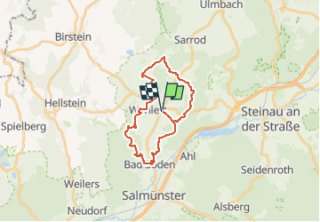
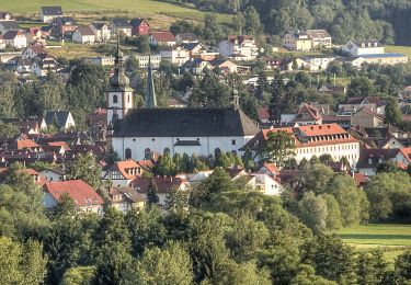
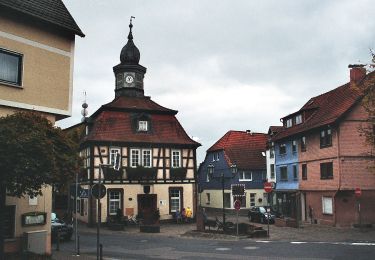
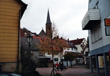
Ruta A pie de 22 km a descubrir en Hesse, Main-Kinzig-Kreis, Bad Soden-Salmünster. Esta ruta ha sido propuesta por SityTrail - itinéraires balisés pédestres.
Descripción
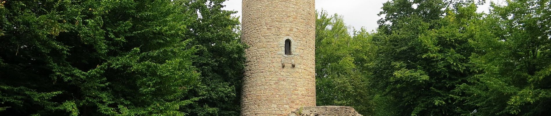
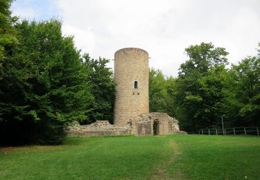
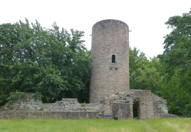
Trail created by Ski & Wanderclub Huttengrund e.V. 1986.
Symbol: Wappen auf weißem Grund
Sitio web: http://www.suwhuttengrund.de/Homepage S&W/Sites/grafvonroedern.html
Localización
Comentarios
Excursiones cerca
![Excursión A pie Bad Soden-Salmünster - Spessartspuren - Bad Sodener Waldgeflüster - Photo](https://media.geolcdn.com/t/375/260/eab33703-db53-400c-8f5e-a96553cdf665.jpeg&format=jpg&maxdim=2)
![A pie A pie](https://static1.geolcdn.com/sitytour/trail-icons/100.png)
A pie
![](/images/other/stat-length.png)
![](https://static1.geolcdn.com/siteimages/upload/files/16400158638029165_repeat_loop_refresh_sync_direction_icon.png)
![Excursión A pie Bad Soden-Salmünster - Stolzenberger Ritterblick ( Spessartfährten ) - Photo](https://media.geolcdn.com/t/375/260/082b6977-d9de-4d85-b235-3038f01e708d.jpeg&format=jpg&maxdim=2)
![A pie A pie](https://static1.geolcdn.com/sitytour/trail-icons/100.png)
A pie
![](/images/other/stat-length.png)
![](https://static1.geolcdn.com/siteimages/upload/files/16400158638029165_repeat_loop_refresh_sync_direction_icon.png)
![Excursión A pie Steinau an der Straße - Steinau a. d. Straße, Wanderweg 3b - Photo](https://media.geolcdn.com/t/375/260/a727d70d-c791-4517-b7dc-042b076b4739.jpeg&format=jpg&maxdim=2)
![A pie A pie](https://static1.geolcdn.com/sitytour/trail-icons/100.png)
A pie
![](/images/other/stat-length.png)
![](https://static1.geolcdn.com/siteimages/upload/files/16400158638029165_repeat_loop_refresh_sync_direction_icon.png)
![Excursión A pie Birstein - Freihölzer Weg - Photo](https://media.geolcdn.com/t/375/260/f0393bf0-8075-44e7-a6ce-e71e9f0d01a9.jpeg&format=jpg&maxdim=2)
![A pie A pie](https://static1.geolcdn.com/sitytour/trail-icons/100.png)
A pie
![](/images/other/stat-length.png)
![](https://static1.geolcdn.com/siteimages/upload/files/16400158638029165_repeat_loop_refresh_sync_direction_icon.png)
![Excursión A pie Steinau an der Straße - Steinau a. d. Straße, Wanderweg 5 - Photo](https://media.geolcdn.com/t/375/260/2f75ce78-7455-4a1f-a522-572d5daa3bf8.jpeg&format=jpg&maxdim=2)
![A pie A pie](https://static1.geolcdn.com/sitytour/trail-icons/100.png)
A pie
![](/images/other/stat-length.png)
![](https://static1.geolcdn.com/siteimages/upload/files/16400158638029165_repeat_loop_refresh_sync_direction_icon.png)
![Excursión A pie Bad Soden-Salmünster - Bad Soden-Salmünster Wanderweg Nr. 25 - Photo](https://media.geolcdn.com/t/375/260/b89c92df-7d0b-4e60-b4f6-ef31cde72362.jpeg&format=jpg&maxdim=2)
![A pie A pie](https://static1.geolcdn.com/sitytour/trail-icons/100.png)
A pie
![](/images/other/stat-length.png)
![](https://static1.geolcdn.com/siteimages/upload/files/16400158638029165_repeat_loop_refresh_sync_direction_icon.png)
![Excursión A pie Bad Soden-Salmünster - Bad Soden-Salmünster Wanderweg Nr. 12 - Photo](https://media.geolcdn.com/t/375/260/580a2ba2-c55b-47db-b3b9-4468dba12ee6.jpeg&format=jpg&maxdim=2)
![A pie A pie](https://static1.geolcdn.com/sitytour/trail-icons/100.png)
A pie
![](/images/other/stat-length.png)
![](https://static1.geolcdn.com/siteimages/upload/files/16400158638029165_repeat_loop_refresh_sync_direction_icon.png)
![Excursión A pie Bad Soden-Salmünster - Bad Soden-Salmünster Wanderweg Nr. 10 - Photo](https://media.geolcdn.com/t/375/260/78dcc63c-7207-4618-9629-c33d53afa663.jpeg&format=jpg&maxdim=2)
![A pie A pie](https://static1.geolcdn.com/sitytour/trail-icons/100.png)
A pie
![](/images/other/stat-length.png)
![](https://static1.geolcdn.com/siteimages/upload/files/16400158638029165_repeat_loop_refresh_sync_direction_icon.png)
![Excursión A pie Bad Soden-Salmünster - Bad Soden-Salmünster Wanderweg Nr. 13 - Photo](https://media.geolcdn.com/t/375/260/78dcc63c-7207-4618-9629-c33d53afa663.jpeg&format=jpg&maxdim=2)
![A pie A pie](https://static1.geolcdn.com/sitytour/trail-icons/100.png)
A pie
![](/images/other/stat-length.png)
![](https://static1.geolcdn.com/siteimages/upload/files/16400158638029165_repeat_loop_refresh_sync_direction_icon.png)