![](/images/other/stat-length.png)
![Excursión A pie Desconocido - Bittermark Rundweg A1 - Photo](https://media.geolcdn.com/t/1900/400/8efc4ce6-a7b0-484c-bae8-6c5bd4503fb3.jpeg&format=pjpeg&maxdim=2)
Bittermark Rundweg A1
SityTrail - itinéraires balisés pédestres
Tous les sentiers balisés d’Europe GUIDE+
![Longitud](/images/other/stat-length.png)
Longitud
4,7 km
![Altitud máxima](https://static1.geolcdn.com/siteimages/upload/files/1508320355ic_sort_altitude_max_24dp.png)
Altitud máxima
256 m
![Desnivel positivo](https://static1.geolcdn.com/siteimages/upload/files/1508320355ic_sort_den_pos_24dp.png)
Desnivel positivo
132 m
![Km-Effort](/images/other/stat-length.png)
Km-Effort
6,2 km
![Altitud mínima](https://static1.geolcdn.com/siteimages/upload/files/1508320355ic_sort_altitude_min_24dp.png)
Altitud mínima
131 m
![Desnivel negativo](https://static1.geolcdn.com/siteimages/upload/files/1508320355ic_sort_den_neg_24dp.png)
Desnivel negativo
60 m
![Boucle](https://static1.geolcdn.com/siteimages/upload/files/16400158638029165_repeat_loop_refresh_sync_direction_icon.png)
Boucle
No
Baliza
Fecha de creación :
2022-02-11 12:52:14.593
Última modificación :
2022-02-11 12:52:14.593
![A pie](https://static1.geolcdn.com/sitytour/trail-icons/100.png)
1h24
Dificultad : Fácil
![Escanee este código QR para abrir la excursión en la aplicación SityTrail](https://capi.geolives.com/qq0zvz2zws4bq2lad0pu/sitytour/trails/3088254/qr.png?size=200)
Aplicación GPS de excursión GRATIS
A propósito
Ruta A pie de 4,7 km a descubrir en Renania del Norte-Westfalia, Dortmund, Desconocido. Esta ruta ha sido propuesta por SityTrail - itinéraires balisés pédestres.
Descripción
Trail created by Sauerländischer Gebirgsverein Bezirk Dortmund Ardey.
Symbol: weißes A1 auf schwarzem Grund
Localización
País:
Germany
Región :
Renania del Norte-Westfalia
Departamento/provincia :
Dortmund
Municipio :
Desconocido
Localidad:
Hombruch
Salida:(Dec)
Salida:(UTM)
393896 ; 5700585 (32U) N.
Comentarios
Excursiones cerca
![Excursión A pie Herdecke - [H3] Hengsteysee und Teufelskanzel - Photo](https://media.geolcdn.com/t/375/260/48a0ef8e-3704-4b57-a4cf-02a57ebc2595.jpeg&format=jpg&maxdim=2)
![A pie A pie](https://static1.geolcdn.com/sitytour/trail-icons/100.png)
[H3] Hengsteysee und Teufelskanzel
A pie
Fácil
Herdecke,
Renania del Norte-Westfalia,
Ennepe-Ruhr-Kreis,
Germany
![](/images/other/stat-length.png)
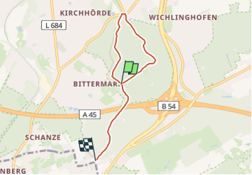
6,7 km | 9,1 km-effort
2h 3min
![](https://static1.geolcdn.com/siteimages/upload/files/16400158638029165_repeat_loop_refresh_sync_direction_icon.png)
No
![Excursión A pie Desconocido - Dortmund-Mittelhöchsten Rundweg A3 - Photo](https://media.geolcdn.com/t/375/260/5bfa077f-c5bb-4b4b-a5d3-7f57095203d7.jpeg&format=jpg&maxdim=2)
![A pie A pie](https://static1.geolcdn.com/sitytour/trail-icons/100.png)
Dortmund-Mittelhöchsten Rundweg A3
A pie
Fácil
Desconocido,
Renania del Norte-Westfalia,
Dortmund,
Germany
![](/images/other/stat-length.png)
3,6 km | 4,6 km-effort
1h 3min
![](https://static1.geolcdn.com/siteimages/upload/files/16400158638029165_repeat_loop_refresh_sync_direction_icon.png)
Sí
![Excursión A pie Desconocido - Dortmund-Mittelhöchsten Rundweg A2 - Photo](https://media.geolcdn.com/t/375/260/5bfa077f-c5bb-4b4b-a5d3-7f57095203d7.jpeg&format=jpg&maxdim=2)
![A pie A pie](https://static1.geolcdn.com/sitytour/trail-icons/100.png)
Dortmund-Mittelhöchsten Rundweg A2
A pie
Fácil
Desconocido,
Renania del Norte-Westfalia,
Dortmund,
Germany
![](/images/other/stat-length.png)
3,1 km | 3,9 km-effort
52min
![](https://static1.geolcdn.com/siteimages/upload/files/16400158638029165_repeat_loop_refresh_sync_direction_icon.png)
Sí
![Excursión A pie Desconocido - Dortmund-Mittelhöchsten Rundweg A1 - Photo](https://media.geolcdn.com/t/375/260/5bfa077f-c5bb-4b4b-a5d3-7f57095203d7.jpeg&format=jpg&maxdim=2)
![A pie A pie](https://static1.geolcdn.com/sitytour/trail-icons/100.png)
Dortmund-Mittelhöchsten Rundweg A1
A pie
Fácil
Desconocido,
Renania del Norte-Westfalia,
Dortmund,
Germany
![](/images/other/stat-length.png)
3,5 km | 4,5 km-effort
1h 1min
![](https://static1.geolcdn.com/siteimages/upload/files/16400158638029165_repeat_loop_refresh_sync_direction_icon.png)
Sí
![Excursión A pie Herdecke - Hickenstein Rundweg A4 - Photo](https://media.geolcdn.com/t/375/260/1b541a9f-06bd-4bdc-8df2-de4349a42b36.jpeg&format=jpg&maxdim=2)
![A pie A pie](https://static1.geolcdn.com/sitytour/trail-icons/100.png)
Hickenstein Rundweg A4
A pie
Fácil
Herdecke,
Renania del Norte-Westfalia,
Ennepe-Ruhr-Kreis,
Germany
![](/images/other/stat-length.png)
6,7 km | 8,9 km-effort
2h 1min
![](https://static1.geolcdn.com/siteimages/upload/files/16400158638029165_repeat_loop_refresh_sync_direction_icon.png)
Sí
![Excursión A pie Desconocido - Löttringhausen Rundweg A4 - Photo](https://media.geolcdn.com/t/375/260/1cd5c06e-e244-4763-9306-8b5d1f9bc187.jpeg&format=jpg&maxdim=2)
![A pie A pie](https://static1.geolcdn.com/sitytour/trail-icons/100.png)
Löttringhausen Rundweg A4
A pie
Fácil
Desconocido,
Renania del Norte-Westfalia,
Dortmund,
Germany
![](/images/other/stat-length.png)
8,2 km | 10,9 km-effort
2h 28min
![](https://static1.geolcdn.com/siteimages/upload/files/16400158638029165_repeat_loop_refresh_sync_direction_icon.png)
Sí
![Excursión A pie Desconocido - [S1] Um den Syberg - Photo](https://media.geolcdn.com/t/375/260/3858086d-bf9c-479b-9500-35a9a92851a8.jpeg&format=jpg&maxdim=2)
![A pie A pie](https://static1.geolcdn.com/sitytour/trail-icons/100.png)
[S1] Um den Syberg
A pie
Fácil
Desconocido,
Renania del Norte-Westfalia,
Dortmund,
Germany
![](/images/other/stat-length.png)
4,3 km | 6,6 km-effort
1h 29min
![](https://static1.geolcdn.com/siteimages/upload/files/16400158638029165_repeat_loop_refresh_sync_direction_icon.png)
Sí
![Excursión A pie Desconocido - Sechs Profile, ein Gesicht - Photo](https://media.geolcdn.com/t/375/260/a8287a5f-bc36-409b-8efc-eccc305eeab0.jpeg&format=jpg&maxdim=2)
![A pie A pie](https://static1.geolcdn.com/sitytour/trail-icons/100.png)
Sechs Profile, ein Gesicht
A pie
Fácil
Desconocido,
Renania del Norte-Westfalia,
Dortmund,
Germany
![](/images/other/stat-length.png)
4,7 km | 6,2 km-effort
1h 24min
![](https://static1.geolcdn.com/siteimages/upload/files/16400158638029165_repeat_loop_refresh_sync_direction_icon.png)
No
![Excursión A pie Desconocido - [S3] Klusenbergrundweg - Photo](https://media.geolcdn.com/t/375/260/48a0ef8e-3704-4b57-a4cf-02a57ebc2595.jpeg&format=jpg&maxdim=2)
![A pie A pie](https://static1.geolcdn.com/sitytour/trail-icons/100.png)
[S3] Klusenbergrundweg
A pie
Fácil
Desconocido,
Renania del Norte-Westfalia,
Dortmund,
Germany
![](/images/other/stat-length.png)
5,6 km | 7,9 km-effort
1h 47min
![](https://static1.geolcdn.com/siteimages/upload/files/16400158638029165_repeat_loop_refresh_sync_direction_icon.png)
Sí