![](/images/other/stat-length.png)
![Excursión Senderismo Escragnolles - Escragnolles, megalithes de Mons, cascade Clar - Photo](https://media.geolcdn.com/t/1900/400/c046b9ca-00b0-4232-a7b9-f9120af0f0f0.jpg&format=pjpeg&maxdim=2)
Escragnolles, megalithes de Mons, cascade Clar
GrouGary
Usuario
![Longitud](/images/other/stat-length.png)
![Altitud máxima](https://static1.geolcdn.com/siteimages/upload/files/1508320355ic_sort_altitude_max_24dp.png)
![Desnivel positivo](https://static1.geolcdn.com/siteimages/upload/files/1508320355ic_sort_den_pos_24dp.png)
![Km-Effort](/images/other/stat-length.png)
![Altitud mínima](https://static1.geolcdn.com/siteimages/upload/files/1508320355ic_sort_altitude_min_24dp.png)
![Desnivel negativo](https://static1.geolcdn.com/siteimages/upload/files/1508320355ic_sort_den_neg_24dp.png)
![Boucle](https://static1.geolcdn.com/siteimages/upload/files/16400158638029165_repeat_loop_refresh_sync_direction_icon.png)
![Senderismo](https://static1.geolcdn.com/sitytour/trail-icons/101.png)
3h02
Dificultad : Fácil
![Escanee este código QR para abrir la excursión en la aplicación SityTrail](https://capi.geolives.com/qq0zvz2zws4bq2lad0pu/sitytour/trails/3006905/qr.png?size=200)
Aplicación GPS de excursión GRATIS
A propósito
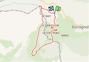
Ruta Senderismo de 9 km a descubrir en Provenza-Alpes-Costa Azul, Alpes Marítimos, Escragnolles. Esta ruta ha sido propuesta por GrouGary.
Descripción
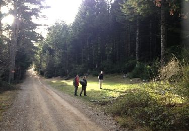
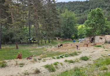
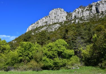
Boucle tranquille dans un paysage rural (moutons,chevaux), entre les villages d'Escragnolles et de Mons.
Nombreux dolmens assez bien conservés, un peu en dehors des sentiers balisés mais facilement repérables.
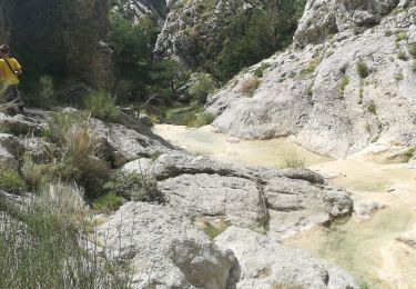
Une cascade magique qui semble sortie d'une résurgence rocheuse.
Localización
Comentarios
Excursiones cerca
![Excursión Senderismo Mons - tour du Mt Lachens - Photo](https://media.geolcdn.com/t/375/260/ext.jpg?maxdim=2&url=https%3A%2F%2Fservices.sitytrail.com%2FGeolivesWS%2FDownloadMedia.ashx%3FTrailID%3D167544%26Media%3D20121228095006.jpg)
![Senderismo Senderismo](https://static1.geolcdn.com/sitytour/trail-icons/101.png)
Senderismo
![](/images/other/stat-length.png)
![](https://static1.geolcdn.com/siteimages/upload/files/16400158638029165_repeat_loop_refresh_sync_direction_icon.png)
![Excursión Senderismo Escragnolles - Casade du Ray (Clars) depuis les Gallants - Photo](https://media.geolcdn.com/t/375/260/a42f38d6-7773-4eff-b635-6c5634fe1592.jpg&format=jpg&maxdim=2)
![Senderismo Senderismo](https://static1.geolcdn.com/sitytour/trail-icons/101.png)
Senderismo
![](/images/other/stat-length.png)
![](https://static1.geolcdn.com/siteimages/upload/files/16400158638029165_repeat_loop_refresh_sync_direction_icon.png)
![Excursión Senderismo Saint-Vallier-de-Thiey - Arche de Ponadieu Source de la Pare Baou Mourine Vieux Pont - Photo](https://media.geolcdn.com/t/375/260/7bf7c645-d759-4e3b-9f63-302e7218f005.jpg&format=jpg&maxdim=2)
![Senderismo Senderismo](https://static1.geolcdn.com/sitytour/trail-icons/101.png)
Senderismo
![](/images/other/stat-length.png)
![](https://static1.geolcdn.com/siteimages/upload/files/16400158638029165_repeat_loop_refresh_sync_direction_icon.png)
![Excursión Senderismo Saint-Vallier-de-Thiey - St Vallier de Thiey - Aqueduc de Belletrud - Arche de Ponadieu - Photo](https://media.geolcdn.com/t/375/260/102f751b-e867-453b-847f-fc313f16fe9f.jpg&format=jpg&maxdim=2)
![Senderismo Senderismo](https://static1.geolcdn.com/sitytour/trail-icons/101.png)
Senderismo
![](/images/other/stat-length.png)
![](https://static1.geolcdn.com/siteimages/upload/files/16400158638029165_repeat_loop_refresh_sync_direction_icon.png)
![Excursión Senderismo Escragnolles - escragnolles mourine - Photo](https://media.geolcdn.com/t/375/260/6cf5f747-cefb-423b-ae55-31ddf95937fc.jpg&format=jpg&maxdim=2)
![Senderismo Senderismo](https://static1.geolcdn.com/sitytour/trail-icons/101.png)
Senderismo
![](/images/other/stat-length.png)
![](https://static1.geolcdn.com/siteimages/upload/files/16400158638029165_repeat_loop_refresh_sync_direction_icon.png)
![Excursión A pie Caille - Grand tour du haut Estéron - Etape 5 - Photo](https://media.geolcdn.com/t/375/260/e0be63bf-1b07-4796-9aef-aaad8742cfa1.jpeg&format=jpg&maxdim=2)
![A pie A pie](https://static1.geolcdn.com/sitytour/trail-icons/100.png)
A pie
![](/images/other/stat-length.png)
![](https://static1.geolcdn.com/siteimages/upload/files/16400158638029165_repeat_loop_refresh_sync_direction_icon.png)
![Excursión A pie Escragnolles - Plateau de Briasq - Photo](https://media.geolcdn.com/t/375/260/3318d519-9f3b-4858-a9ae-b470b623f859.jpeg&format=jpg&maxdim=2)
![A pie A pie](https://static1.geolcdn.com/sitytour/trail-icons/100.png)
A pie
![](/images/other/stat-length.png)
![](https://static1.geolcdn.com/siteimages/upload/files/16400158638029165_repeat_loop_refresh_sync_direction_icon.png)
![Excursión Senderismo Andon - L'Audibergue du Pont du Loup - Photo](https://media.geolcdn.com/t/375/260/461a541c-f76c-4a15-9b4e-2811bf184191.jpg&format=jpg&maxdim=2)
![Senderismo Senderismo](https://static1.geolcdn.com/sitytour/trail-icons/101.png)
Senderismo
![](/images/other/stat-length.png)
![](https://static1.geolcdn.com/siteimages/upload/files/16400158638029165_repeat_loop_refresh_sync_direction_icon.png)
![Senderismo Senderismo](https://static1.geolcdn.com/sitytour/trail-icons/101.png)
Senderismo
![](/images/other/stat-length.png)
![](https://static1.geolcdn.com/siteimages/upload/files/16400158638029165_repeat_loop_refresh_sync_direction_icon.png)