![](/images/other/stat-length.png)
![Excursión Senderismo Mayres - chaumiène astet - Photo](https://media.geolcdn.com/t/1900/400/ext.pjpeg?maxdim=2&url=https%3A%2F%2Fstatic1.geolcdn.com%2Fsiteimages%2Fupload%2Ffiles%2F1553511878bg_sport_marche.png)
chaumiène astet
evefrancois@orange.fr
Usuario
![Longitud](/images/other/stat-length.png)
Longitud
16,8 km
![Altitud máxima](https://static1.geolcdn.com/siteimages/upload/files/1508320355ic_sort_altitude_max_24dp.png)
Altitud máxima
1424 m
![Desnivel positivo](https://static1.geolcdn.com/siteimages/upload/files/1508320355ic_sort_den_pos_24dp.png)
Desnivel positivo
875 m
![Km-Effort](/images/other/stat-length.png)
Km-Effort
28 km
![Altitud mínima](https://static1.geolcdn.com/siteimages/upload/files/1508320355ic_sort_altitude_min_24dp.png)
Altitud mínima
648 m
![Desnivel negativo](https://static1.geolcdn.com/siteimages/upload/files/1508320355ic_sort_den_neg_24dp.png)
Desnivel negativo
876 m
![Boucle](https://static1.geolcdn.com/siteimages/upload/files/16400158638029165_repeat_loop_refresh_sync_direction_icon.png)
Boucle
Sí
Fecha de creación :
2021-09-07 19:46:14.738
Última modificación :
2021-09-07 19:46:17.038
![Senderismo](https://static1.geolcdn.com/sitytour/trail-icons/101.png)
6h28
Dificultad : Muy difícil
![Escanee este código QR para abrir la excursión en la aplicación SityTrail](https://capi.geolives.com/qq0zvz2zws4bq2lad0pu/sitytour/trails/2928754/qr.png?size=200)
Aplicación GPS de excursión GRATIS
A propósito
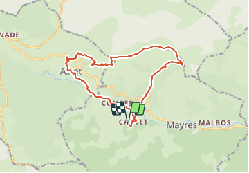
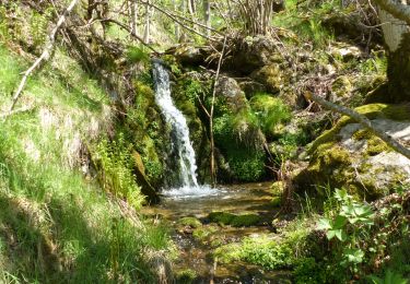
Ruta Senderismo de 16,8 km a descubrir en Auvergne-Rhône-Alpes, Ardecha, Mayres. Esta ruta ha sido propuesta por evefrancois@orange.fr.
Descripción
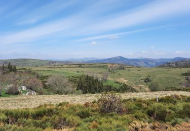
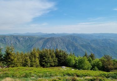
belle boucle sur les crêtes de chaumiène et plongeon dans le vallon d'Astet. descente en suivant l'Ardèche
de torrents en baignoires.
Localización
País:
France
Región :
Auvergne-Rhône-Alpes
Departamento/provincia :
Ardecha
Municipio :
Mayres
Localidad:
Unknown
Salida:(Dec)
Salida:(UTM)
586206 ; 4946460 (31T) N.
Comentarios
Excursiones cerca
![Excursión Senderismo Mayres - 07 rocher d abraham - Photo](https://media.geolcdn.com/t/375/260/ext.jpg?maxdim=2&url=https%3A%2F%2Fstatic1.geolcdn.com%2Fsiteimages%2Fupload%2Ffiles%2F1553511878bg_sport_marche.png)
![Senderismo Senderismo](https://static1.geolcdn.com/sitytour/trail-icons/101.png)
07 rocher d abraham
Senderismo
Medio
(2)
Mayres,
Auvergne-Rhône-Alpes,
Ardecha,
France
![](/images/other/stat-length.png)
14 km | 28 km-effort
8h 4min
![](https://static1.geolcdn.com/siteimages/upload/files/16400158638029165_repeat_loop_refresh_sync_direction_icon.png)
Sí
![Excursión Senderismo Borne - croix de beauzon - Photo](https://media.geolcdn.com/t/375/260/217677dd-c155-48af-bc87-419b5b32c8ce.jpg&format=jpg&maxdim=2)
![Senderismo Senderismo](https://static1.geolcdn.com/sitytour/trail-icons/101.png)
croix de beauzon
Senderismo
Difícil
Borne,
Auvergne-Rhône-Alpes,
Ardecha,
France
![](/images/other/stat-length.png)
13,6 km | 18,2 km-effort
5h 53min
![](https://static1.geolcdn.com/siteimages/upload/files/16400158638029165_repeat_loop_refresh_sync_direction_icon.png)
Sí
![Excursión Senderismo Mayres - Mayres Chaumiène 12km - Photo](https://media.geolcdn.com/t/375/260/a133b020-a8a4-4863-bdb6-488ddda17997.jpg&format=jpg&maxdim=2)
![Senderismo Senderismo](https://static1.geolcdn.com/sitytour/trail-icons/101.png)
Mayres Chaumiène 12km
Senderismo
Difícil
Mayres,
Auvergne-Rhône-Alpes,
Ardecha,
France
![](/images/other/stat-length.png)
12,2 km | 23 km-effort
6h 43min
![](https://static1.geolcdn.com/siteimages/upload/files/16400158638029165_repeat_loop_refresh_sync_direction_icon.png)
Sí
![Excursión Senderismo Borne - 2023-01-26_14h31m24_Station Croix de Bauzon 14 km.gpx.xml - Photo](https://media.geolcdn.com/t/375/260/186f655e-2b32-453c-b04b-facbcec1469b.jpg&format=jpg&maxdim=2)
![Senderismo Senderismo](https://static1.geolcdn.com/sitytour/trail-icons/101.png)
2023-01-26_14h31m24_Station Croix de Bauzon 14 km.gpx.xml
Senderismo
Difícil
Borne,
Auvergne-Rhône-Alpes,
Ardecha,
France
![](/images/other/stat-length.png)
13,9 km | 19,2 km-effort
4h 22min
![](https://static1.geolcdn.com/siteimages/upload/files/16400158638029165_repeat_loop_refresh_sync_direction_icon.png)
Sí
![Excursión A pie Mayres - Tour des Poignets 18km - Photo](https://media.geolcdn.com/t/375/260/4695ff56-51f7-439d-a787-0d719ef81c46.jpg&format=jpg&maxdim=2)
![A pie A pie](https://static1.geolcdn.com/sitytour/trail-icons/100.png)
Tour des Poignets 18km
A pie
Medio
Mayres,
Auvergne-Rhône-Alpes,
Ardecha,
France
![](/images/other/stat-length.png)
17,1 km | 25 km-effort
5h 42min
![](https://static1.geolcdn.com/siteimages/upload/files/16400158638029165_repeat_loop_refresh_sync_direction_icon.png)
Sí
![Excursión Senderismo Saint-Étienne-de-Lugdarès - Le Bez-Borne-les Chambons - Photo](https://media.geolcdn.com/t/375/260/84516e8e-4390-46d3-bf0d-44f54607fcbb.jpg&format=jpg&maxdim=2)
![Senderismo Senderismo](https://static1.geolcdn.com/sitytour/trail-icons/101.png)
Le Bez-Borne-les Chambons
Senderismo
Difícil
Saint-Étienne-de-Lugdarès,
Auvergne-Rhône-Alpes,
Ardecha,
France
![](/images/other/stat-length.png)
14,1 km | 22 km-effort
5h 20min
![](https://static1.geolcdn.com/siteimages/upload/files/16400158638029165_repeat_loop_refresh_sync_direction_icon.png)
Sí
![Excursión Senderismo Borne - Vallée de la Borne - Photo](https://media.geolcdn.com/t/375/260/a1b498ea-d1c1-4335-9a23-7d6d1fab4a20.jpg&format=jpg&maxdim=2)
![Senderismo Senderismo](https://static1.geolcdn.com/sitytour/trail-icons/101.png)
Vallée de la Borne
Senderismo
Difícil
Borne,
Auvergne-Rhône-Alpes,
Ardecha,
France
![](/images/other/stat-length.png)
14,2 km | 22 km-effort
6h 8min
![](https://static1.geolcdn.com/siteimages/upload/files/16400158638029165_repeat_loop_refresh_sync_direction_icon.png)
Sí
![Excursión Senderismo La Souche - Rocher d'Abraham par la Tour des Poignets - Photo](https://media.geolcdn.com/t/375/260/7fafd23c-0b70-4e8a-8e13-fea6920ba10a.jpg&format=jpg&maxdim=2)
![Senderismo Senderismo](https://static1.geolcdn.com/sitytour/trail-icons/101.png)
Rocher d'Abraham par la Tour des Poignets
Senderismo
Difícil
La Souche,
Auvergne-Rhône-Alpes,
Ardecha,
France
![](/images/other/stat-length.png)
10,9 km | 17,1 km-effort
5h 33min
![](https://static1.geolcdn.com/siteimages/upload/files/16400158638029165_repeat_loop_refresh_sync_direction_icon.png)
Sí
![Excursión Senderismo Mayres - Mayres Chaumiène 12km - Photo](https://media.geolcdn.com/t/375/260/3d9e159f-ae3c-4dd5-9273-9d6647836aaa.jpg&format=jpg&maxdim=2)
![Senderismo Senderismo](https://static1.geolcdn.com/sitytour/trail-icons/101.png)
Mayres Chaumiène 12km
Senderismo
Difícil
Mayres,
Auvergne-Rhône-Alpes,
Ardecha,
France
![](/images/other/stat-length.png)
11,7 km | 22 km-effort
4h 25min
![](https://static1.geolcdn.com/siteimages/upload/files/16400158638029165_repeat_loop_refresh_sync_direction_icon.png)
Sí