![](/images/other/stat-length.png)
![Excursión Senderismo Orsières - TMB 07 - La Fouly -> Relais d'Arpette - Photo](https://media.geolcdn.com/t/1900/400/ext.pjpeg?maxdim=2&url=https%3A%2F%2Fstatic1.geolcdn.com%2Fsiteimages%2Fupload%2Ffiles%2F1553511878bg_sport_marche.png)
TMB 07 - La Fouly -> Relais d'Arpette
uru2010
Usuario
![Longitud](/images/other/stat-length.png)
Longitud
17,3 km
![Altitud máxima](https://static1.geolcdn.com/siteimages/upload/files/1508320355ic_sort_altitude_max_24dp.png)
Altitud máxima
1633 m
![Desnivel positivo](https://static1.geolcdn.com/siteimages/upload/files/1508320355ic_sort_den_pos_24dp.png)
Desnivel positivo
706 m
![Km-Effort](/images/other/stat-length.png)
Km-Effort
27 km
![Altitud mínima](https://static1.geolcdn.com/siteimages/upload/files/1508320355ic_sort_altitude_min_24dp.png)
Altitud mínima
1048 m
![Desnivel negativo](https://static1.geolcdn.com/siteimages/upload/files/1508320355ic_sort_den_neg_24dp.png)
Desnivel negativo
677 m
![Boucle](https://static1.geolcdn.com/siteimages/upload/files/16400158638029165_repeat_loop_refresh_sync_direction_icon.png)
Boucle
No
Fecha de creación :
2021-06-29 06:32:56.622
Última modificación :
2022-05-08 14:44:58.713
![Senderismo](https://static1.geolcdn.com/sitytour/trail-icons/101.png)
5h46
Dificultad : Difícil
![Escanee este código QR para abrir la excursión en la aplicación SityTrail](https://capi.geolives.com/qq0zvz2zws4bq2lad0pu/sitytour/trails/2844395/qr.png?size=200)
Aplicación GPS de excursión GRATIS
A propósito
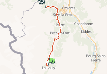
Ruta Senderismo de 17,3 km a descubrir en Vallés, Entremont, Orsières. Esta ruta ha sido propuesta por uru2010.
Descripción
Départ : Hôtel Edelweiss, La Fouly.
Arrivée : Relais d'Arpette, Arpette. Tél : 41 27 783 12 21.
Randonnée faite le 29/6/2021.
Durée suivant le guide : 5h50. Ma durée réelle : 5h45.
Localización
País:
Switzerland
Región :
Vallés
Departamento/provincia :
Entremont
Municipio :
Orsières
Localidad:
Unknown
Salida:(Dec)
Salida:(UTM)
352584 ; 5088443 (32T) N.
Comentarios
Excursiones cerca
![Excursión A pie Orsières - Trail Verbier St-Bernard - Traversée - Photo](https://media.geolcdn.com/t/375/260/dafbc912-1c22-4e42-aaf9-5568981fc800.jpeg&format=jpg&maxdim=2)
![A pie A pie](https://static1.geolcdn.com/sitytour/trail-icons/100.png)
Trail Verbier St-Bernard - Traversée
A pie
Muy difícil
Orsières,
Vallés,
Entremont,
Switzerland
![](/images/other/stat-length.png)
37 km | 70 km-effort
15h 47min
![](https://static1.geolcdn.com/siteimages/upload/files/16400158638029165_repeat_loop_refresh_sync_direction_icon.png)
No
![Excursión A pie Orsières - Sentier des Bergers - Photo](https://media.geolcdn.com/t/375/260/a8cdee56-d9cf-46a0-9048-05577c82dfc2.jpeg&format=jpg&maxdim=2)
![A pie A pie](https://static1.geolcdn.com/sitytour/trail-icons/100.png)
Sentier des Bergers
A pie
Fácil
Orsières,
Vallés,
Entremont,
Switzerland
![](/images/other/stat-length.png)
4,8 km | 9,2 km-effort
2h 5min
![](https://static1.geolcdn.com/siteimages/upload/files/16400158638029165_repeat_loop_refresh_sync_direction_icon.png)
No
![Excursión Senderismo Orsières - La Fouly Ferret - Photo](https://media.geolcdn.com/t/375/260/9ccbcdc3-96f7-4967-963b-9422de80e17a.jpg&format=jpg&maxdim=2)
![Senderismo Senderismo](https://static1.geolcdn.com/sitytour/trail-icons/101.png)
La Fouly Ferret
Senderismo
Medio
Orsières,
Vallés,
Entremont,
Switzerland
![](/images/other/stat-length.png)
6,4 km | 9,7 km-effort
2h 58min
![](https://static1.geolcdn.com/siteimages/upload/files/16400158638029165_repeat_loop_refresh_sync_direction_icon.png)
Sí
![Excursión A pie Courmayeur - Itinerario 23 Rifugio Dalmazzi - Photo](https://media.geolcdn.com/t/375/260/2530e1b3-3a61-40c9-a091-23aae0135330.jpeg&format=jpg&maxdim=2)
![A pie A pie](https://static1.geolcdn.com/sitytour/trail-icons/100.png)
Itinerario 23 Rifugio Dalmazzi
A pie
Fácil
Courmayeur,
Valle de Aosta,
Desconocido,
Italy
![](/images/other/stat-length.png)
4,1 km | 6,6 km-effort
1h 29min
![](https://static1.geolcdn.com/siteimages/upload/files/16400158638029165_repeat_loop_refresh_sync_direction_icon.png)
No
![Excursión Senderismo Orsières - La Fouly, Randonée hivernale, Sentier de l''Amône - Photo](https://media.geolcdn.com/t/375/260/ext.jpg?maxdim=2&url=https%3A%2F%2Fstatic1.geolcdn.com%2Fsiteimages%2Fupload%2Ffiles%2F1553511878bg_sport_marche.png)
![Senderismo Senderismo](https://static1.geolcdn.com/sitytour/trail-icons/101.png)
La Fouly, Randonée hivernale, Sentier de l''Amône
Senderismo
Muy fácil
(1)
Orsières,
Vallés,
Entremont,
Switzerland
![](/images/other/stat-length.png)
1,9 km | 2,7 km-effort
50min
![](https://static1.geolcdn.com/siteimages/upload/files/16400158638029165_repeat_loop_refresh_sync_direction_icon.png)
Sí
![Excursión Senderismo Orsières - ferret La Foully - Photo](https://media.geolcdn.com/t/375/260/63d1d980-6a97-41e6-89ba-75cc5f32987c.jpg&format=jpg&maxdim=2)
![Senderismo Senderismo](https://static1.geolcdn.com/sitytour/trail-icons/101.png)
ferret La Foully
Senderismo
Medio
Orsières,
Vallés,
Entremont,
Switzerland
![](/images/other/stat-length.png)
4,6 km | 6,1 km-effort
2h 20min
![](https://static1.geolcdn.com/siteimages/upload/files/16400158638029165_repeat_loop_refresh_sync_direction_icon.png)
No
![Excursión Senderismo Orsières - fully - Photo](https://media.geolcdn.com/t/375/260/2c6e4eef-8fbd-4687-9f38-cba51571dc4d.jpg&format=jpg&maxdim=2)
![Senderismo Senderismo](https://static1.geolcdn.com/sitytour/trail-icons/101.png)
![Excursión Senderismo Orsières - TMB J3 La FOULY - Ref. ELENA - Photo](https://media.geolcdn.com/t/375/260/ext.jpg?maxdim=2&url=https%3A%2F%2Fservices.sitytrail.com%2FGeolivesWS%2FDownloadMedia.ashx%3FTrailID%3D594964%26Media%3Dfix__20160705112101.jpg)
![Senderismo Senderismo](https://static1.geolcdn.com/sitytour/trail-icons/101.png)
TMB J3 La FOULY - Ref. ELENA
Senderismo
Difícil
Orsières,
Vallés,
Entremont,
Switzerland
![](/images/other/stat-length.png)
10,3 km | 23 km-effort
4h 46min
![](https://static1.geolcdn.com/siteimages/upload/files/16400158638029165_repeat_loop_refresh_sync_direction_icon.png)
No
![Excursión Senderismo Orsières - Cabane de l''A Neuve - Photo](https://media.geolcdn.com/t/375/260/ext.jpg?maxdim=2&url=https%3A%2F%2Fservices.sitytrail.com%2FGeolivesWS%2FDownloadMedia.ashx%3FTrailID%3D43029%26Media%3Dimage0.jpg)
![Senderismo Senderismo](https://static1.geolcdn.com/sitytour/trail-icons/101.png)
Cabane de l''A Neuve
Senderismo
Muy fácil
Orsières,
Vallés,
Entremont,
Switzerland
![](/images/other/stat-length.png)
5,4 km | 16,6 km-effort
2h 43min
![](https://static1.geolcdn.com/siteimages/upload/files/16400158638029165_repeat_loop_refresh_sync_direction_icon.png)
No