![](/images/other/stat-length.png)
![Excursión Raquetas de nieve Saint-Christophe-sur-Guiers - Chartreuse La Ruchère Cols de l'Aliénard et de la Ruchère - Photo](https://media.geolcdn.com/t/1900/400/ext.pjpeg?maxdim=2&url=https%3A%2F%2Fstatic1.geolcdn.com%2Fsiteimages%2Fupload%2Ffiles%2F1524743153raquette.jpg)
Chartreuse La Ruchère Cols de l'Aliénard et de la Ruchère
c.gourme
Usuario
![Longitud](/images/other/stat-length.png)
![Altitud máxima](https://static1.geolcdn.com/siteimages/upload/files/1508320355ic_sort_altitude_max_24dp.png)
![Desnivel positivo](https://static1.geolcdn.com/siteimages/upload/files/1508320355ic_sort_den_pos_24dp.png)
![Km-Effort](/images/other/stat-length.png)
![Altitud mínima](https://static1.geolcdn.com/siteimages/upload/files/1508320355ic_sort_altitude_min_24dp.png)
![Desnivel negativo](https://static1.geolcdn.com/siteimages/upload/files/1508320355ic_sort_den_neg_24dp.png)
![Boucle](https://static1.geolcdn.com/siteimages/upload/files/16400158638029165_repeat_loop_refresh_sync_direction_icon.png)
![Raquetas de nieve](https://static1.geolcdn.com/sitytour/trail-icons/504.png)
5h14
Dificultad : Medio
![Escanee este código QR para abrir la excursión en la aplicación SityTrail](https://capi.geolives.com/qq0zvz2zws4bq2lad0pu/sitytour/trails/2656312/qr.png?size=200)
Aplicación GPS de excursión GRATIS
A propósito
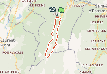
Ruta Raquetas de nieve de 11,1 km a descubrir en Auvergne-Rhône-Alpes, Isère, Saint-Christophe-sur-Guiers. Esta ruta ha sido propuesta por c.gourme.
Descripción
Attention : Coulées d'avalanche sur le chemin de retour vers l'oratoire.
On aboutit sur une route : le mieux est sans doute de revenir par le même
chemin en passant par le Tracol après le col de la Ruchère.
Localización
Comentarios
Excursiones cerca
![Excursión Raquetas de nieve Saint-Christophe-sur-Guiers - Le Belvédère d'Arpison - Photo](https://media.geolcdn.com/t/375/260/ext.jpg?maxdim=2&url=https%3A%2F%2Fservices.sitytrail.com%2FGeolivesWS%2FDownloadMedia.ashx%3FTrailID%3D699429%26Media%3Dfix__20170216145739.jpg)
![Raquetas de nieve Raquetas de nieve](https://static1.geolcdn.com/sitytour/trail-icons/504.png)
Raquetas de nieve
![](/images/other/stat-length.png)
![](https://static1.geolcdn.com/siteimages/upload/files/16400158638029165_repeat_loop_refresh_sync_direction_icon.png)
![Excursión Senderismo Saint-Pierre-d'Entremont - Le Grand Som 2026m, depuis Saint-Philibert - Photo](https://media.geolcdn.com/t/375/260/ext.jpg?maxdim=2&url=https%3A%2F%2Fservices.sitytrail.com%2FGeolivesWS%2FDownloadMedia.ashx%3FTrailID%3D107472%26Media%3D12415_1.jpg)
![Senderismo Senderismo](https://static1.geolcdn.com/sitytour/trail-icons/101.png)
Senderismo
![](/images/other/stat-length.png)
![](https://static1.geolcdn.com/siteimages/upload/files/16400158638029165_repeat_loop_refresh_sync_direction_icon.png)
![Excursión Senderismo Saint-Pierre-d'Entremont - Roche Veyrand par les Clapiers, 1429m - Photo](https://media.geolcdn.com/t/375/260/ext.jpg?maxdim=2&url=https%3A%2F%2Fservices.sitytrail.com%2FGeolivesWS%2FDownloadMedia.ashx%3FTrailID%3D101734%26Media%3D1981_1.jpg)
![Senderismo Senderismo](https://static1.geolcdn.com/sitytour/trail-icons/101.png)
Senderismo
![](/images/other/stat-length.png)
![](https://static1.geolcdn.com/siteimages/upload/files/16400158638029165_repeat_loop_refresh_sync_direction_icon.png)
![Excursión Senderismo Saint-Christophe-sur-Guiers - Petit Som 1772m, depuis La Ruchère - Photo](https://media.geolcdn.com/t/375/260/ext.jpg?maxdim=2&url=https%3A%2F%2Fservices.sitytrail.com%2FGeolivesWS%2FDownloadMedia.ashx%3FTrailID%3D101428%26Media%3D1421_1.jpg)
![Senderismo Senderismo](https://static1.geolcdn.com/sitytour/trail-icons/101.png)
Senderismo
![](/images/other/stat-length.png)
![](https://static1.geolcdn.com/siteimages/upload/files/16400158638029165_repeat_loop_refresh_sync_direction_icon.png)
![Excursión Bici de carretera Corbel - Entreront - Photo](https://media.geolcdn.com/t/375/260/9b42e589-105e-4d70-99b0-df835d2b48ea.jpg&format=jpg&maxdim=2)
![Bici de carretera Bici de carretera](https://static1.geolcdn.com/sitytour/trail-icons/201.png)
Bici de carretera
![](/images/other/stat-length.png)
![](https://static1.geolcdn.com/siteimages/upload/files/16400158638029165_repeat_loop_refresh_sync_direction_icon.png)
![Excursión Senderismo Saint-Christophe-sur-Guiers - 38 grand som par sente intermediaire - Photo](https://media.geolcdn.com/t/375/260/d5932087-ede9-44fd-a20e-8bcb7625b7eb.jpg&format=jpg&maxdim=2)
![Senderismo Senderismo](https://static1.geolcdn.com/sitytour/trail-icons/101.png)
Senderismo
![](/images/other/stat-length.png)
![](https://static1.geolcdn.com/siteimages/upload/files/16400158638029165_repeat_loop_refresh_sync_direction_icon.png)
![Excursión Senderismo Saint-Christophe - 38 st Christophe sur guiers grottes guiers vif - Photo](https://media.geolcdn.com/t/375/260/b80de980-1ba2-4651-878b-a9fe13ee8ba9.jpg&format=jpg&maxdim=2)
![Senderismo Senderismo](https://static1.geolcdn.com/sitytour/trail-icons/101.png)
Senderismo
![](/images/other/stat-length.png)
![](https://static1.geolcdn.com/siteimages/upload/files/16400158638029165_repeat_loop_refresh_sync_direction_icon.png)
![Excursión Esquí de fondo Saint-Christophe-sur-Guiers - Col de mauvernay, de Bovinant, du Frêt et Petit Som - Photo](https://media.geolcdn.com/t/375/260/419264db-ef9b-4542-9a8f-6ba6585137b1.jpg&format=jpg&maxdim=2)
![Esquí de fondo Esquí de fondo](https://static1.geolcdn.com/sitytour/trail-icons/503.png)
Esquí de fondo
![](/images/other/stat-length.png)
![](https://static1.geolcdn.com/siteimages/upload/files/16400158638029165_repeat_loop_refresh_sync_direction_icon.png)
![Excursión Senderismo Saint-Christophe-sur-Guiers - Petit Som par le Col de la Ruchère - Photo](https://media.geolcdn.com/t/375/260/ext.jpg?maxdim=2&url=https%3A%2F%2Fservices.sitytrail.com%2FGeolivesWS%2FDownloadMedia.ashx%3FTrailID%3D187990%26Media%3D84dca246-9935-47c1-bea7-9350caca3e85.JPG)
![Senderismo Senderismo](https://static1.geolcdn.com/sitytour/trail-icons/101.png)
Senderismo
![](/images/other/stat-length.png)
![](https://static1.geolcdn.com/siteimages/upload/files/16400158638029165_repeat_loop_refresh_sync_direction_icon.png)