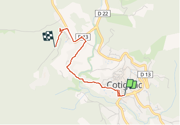
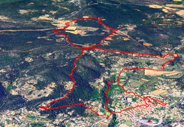
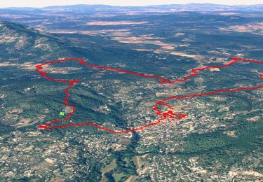
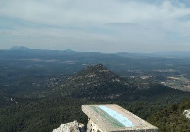
![](/images/other/stat-length.png)
![Excursión Otra actividad Cotignac - COTIGNAC (La glacière) - Photo](https://media.geolcdn.com/t/1900/400/ext.pjpeg?maxdim=2&url=https%3A%2F%2Fstatic1.geolcdn.com%2Fsiteimages%2Fupload%2Ffiles%2F1545311037marcheuse_200dpi.jpg)
COTIGNAC (La glacière)
Elbe
Usuario
![Longitud](/images/other/stat-length.png)
![Altitud máxima](https://static1.geolcdn.com/siteimages/upload/files/1508320355ic_sort_altitude_max_24dp.png)
![Desnivel positivo](https://static1.geolcdn.com/siteimages/upload/files/1508320355ic_sort_den_pos_24dp.png)
![Km-Effort](/images/other/stat-length.png)
![Altitud mínima](https://static1.geolcdn.com/siteimages/upload/files/1508320355ic_sort_altitude_min_24dp.png)
![Desnivel negativo](https://static1.geolcdn.com/siteimages/upload/files/1508320355ic_sort_den_neg_24dp.png)
![Boucle](https://static1.geolcdn.com/siteimages/upload/files/16400158638029165_repeat_loop_refresh_sync_direction_icon.png)
![Otra actividad](https://static1.geolcdn.com/sitytour/trail-icons/900.png)
1h00
Dificultad : Desconocido
![Escanee este código QR para abrir la excursión en la aplicación SityTrail](https://capi.geolives.com/qq0zvz2zws4bq2lad0pu/sitytour/trails/261403/qr.png?size=200)
Aplicación GPS de excursión GRATIS
A propósito
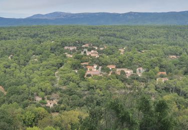
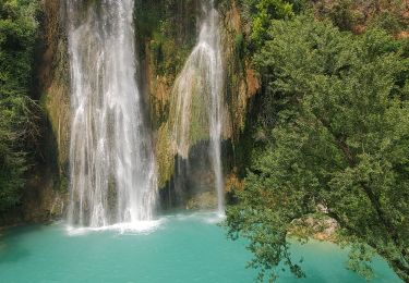
Ruta Otra actividad de 2,5 km a descubrir en Provenza-Alpes-Costa Azul, Var, Cotignac. Esta ruta ha sido propuesta por Elbe.
Descripción
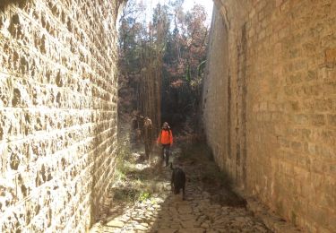
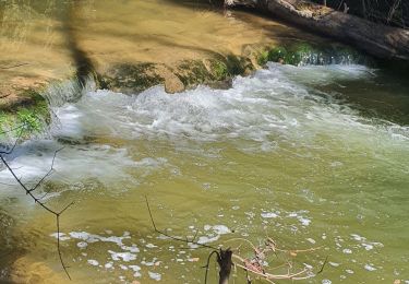
Glacière privée du château d’Entrecasteaux construite contre le rempart. La dame de Venel a obtenu en 1648 le privilège de construire des glacières, vendre et débiter la glace dans toute la Provence. Les villageois alimentent la glacière l’hiver par l’eau qui gèle le long de la rivière, et peuvent bénéficier de glace l’été.
Localización
Comentarios
Excursiones cerca
![Excursión Senderismo Cotignac - SityTrail - Notre Dame de Grace - Chapelle St Bernard - Monastere St Joseph - Chapelle St Martin - Le Poucet - Habitat troglodyte - Le village - Photo](https://media.geolcdn.com/t/375/260/3df5ec25-d552-4f62-91dd-9a69845e3551.jpg&format=jpg&maxdim=2)
![Senderismo Senderismo](https://static1.geolcdn.com/sitytour/trail-icons/101.png)
Senderismo
![](/images/other/stat-length.png)
![](https://static1.geolcdn.com/siteimages/upload/files/16400158638029165_repeat_loop_refresh_sync_direction_icon.png)
![Excursión Senderismo Sillans-la-Cascade - Trace_Sillans - Photo](https://media.geolcdn.com/t/375/260/4b45470f-3ffd-48ed-a237-4271c6a3710f.jpg&format=jpg&maxdim=2)
![Senderismo Senderismo](https://static1.geolcdn.com/sitytour/trail-icons/101.png)
Senderismo
![](/images/other/stat-length.png)
![](https://static1.geolcdn.com/siteimages/upload/files/16400158638029165_repeat_loop_refresh_sync_direction_icon.png)
![Excursión Senderismo Cotignac - Trace_Cotignac - Photo](https://media.geolcdn.com/t/375/260/f720fb36-9a63-45e5-a4fe-2f41a31767be.jpg&format=jpg&maxdim=2)
![Senderismo Senderismo](https://static1.geolcdn.com/sitytour/trail-icons/101.png)
Senderismo
![](/images/other/stat-length.png)
![](https://static1.geolcdn.com/siteimages/upload/files/16400158638029165_repeat_loop_refresh_sync_direction_icon.png)
![Excursión Senderismo Sillans-la-Cascade - Caseneuve - Photo](https://media.geolcdn.com/t/375/260/ext.jpg?maxdim=2&url=https%3A%2F%2Fservices.sitytrail.com%2FGeolivesWS%2FDownloadMedia.ashx%3FTrailID%3D699653%26Media%3D20170105120554.jpg)
![Senderismo Senderismo](https://static1.geolcdn.com/sitytour/trail-icons/101.png)
Senderismo
![](/images/other/stat-length.png)
![](https://static1.geolcdn.com/siteimages/upload/files/16400158638029165_repeat_loop_refresh_sync_direction_icon.png)
![Excursión Senderismo Sillans-la-Cascade - 2024-03-05 La Bresque - Photo](https://media.geolcdn.com/t/375/260/c9038386-6b03-4f45-be3c-f8ce6bafb362.jpg&format=jpg&maxdim=2)
![Senderismo Senderismo](https://static1.geolcdn.com/sitytour/trail-icons/101.png)
Senderismo
![](/images/other/stat-length.png)
![](https://static1.geolcdn.com/siteimages/upload/files/16400158638029165_repeat_loop_refresh_sync_direction_icon.png)
![Excursión Senderismo Sillans-la-Cascade - 2023-10-22 La Bresque mystérieuse - Photo](https://media.geolcdn.com/t/375/260/ee8614e1-7a27-45d8-a32a-4b544fdb8d39.jpg&format=jpg&maxdim=2)
![Senderismo Senderismo](https://static1.geolcdn.com/sitytour/trail-icons/101.png)
Senderismo
![](/images/other/stat-length.png)
![](https://static1.geolcdn.com/siteimages/upload/files/16400158638029165_repeat_loop_refresh_sync_direction_icon.png)
![Excursión Senderismo Sillans-la-Cascade - 23-10-2022 Sillans La Cascade - Croix de Solliès - Salernes - Photo](https://media.geolcdn.com/t/375/260/e872b945-c289-4b77-8147-4bedd1cc41eb.jpg&format=jpg&maxdim=2)
![Senderismo Senderismo](https://static1.geolcdn.com/sitytour/trail-icons/101.png)
Senderismo
![](/images/other/stat-length.png)
![](https://static1.geolcdn.com/siteimages/upload/files/16400158638029165_repeat_loop_refresh_sync_direction_icon.png)
![Excursión Senderismo Sillans-la-Cascade - seillan 400m 14kms - Photo](https://media.geolcdn.com/t/375/260/da3715af-554a-4a18-b362-45ad0923842d.jpg&format=jpg&maxdim=2)
![Senderismo Senderismo](https://static1.geolcdn.com/sitytour/trail-icons/101.png)
Senderismo
![](/images/other/stat-length.png)
![](https://static1.geolcdn.com/siteimages/upload/files/16400158638029165_repeat_loop_refresh_sync_direction_icon.png)
![Excursión Senderismo Cotignac - Tour du gros Bessillon - Photo](https://media.geolcdn.com/t/375/260/779808d6-cf2d-4575-a137-1a82d1025a08.jpg&format=jpg&maxdim=2)
![Senderismo Senderismo](https://static1.geolcdn.com/sitytour/trail-icons/101.png)
Senderismo
![](/images/other/stat-length.png)
![](https://static1.geolcdn.com/siteimages/upload/files/16400158638029165_repeat_loop_refresh_sync_direction_icon.png)