![](/images/other/stat-length.png)
![Excursión Senderismo Rencurel - Les fromages et les ailes - Photo](https://media.geolcdn.com/t/1900/400/ext.pjpeg?maxdim=2&url=https%3A%2F%2Fstatic1.geolcdn.com%2Fsiteimages%2Fupload%2Ffiles%2F1553511878bg_sport_marche.png)
Les fromages et les ailes
pgeiger
Usuario
![Longitud](/images/other/stat-length.png)
Longitud
10,4 km
![Altitud máxima](https://static1.geolcdn.com/siteimages/upload/files/1508320355ic_sort_altitude_max_24dp.png)
Altitud máxima
1169 m
![Desnivel positivo](https://static1.geolcdn.com/siteimages/upload/files/1508320355ic_sort_den_pos_24dp.png)
Desnivel positivo
447 m
![Km-Effort](/images/other/stat-length.png)
Km-Effort
16,3 km
![Altitud mínima](https://static1.geolcdn.com/siteimages/upload/files/1508320355ic_sort_altitude_min_24dp.png)
Altitud mínima
799 m
![Desnivel negativo](https://static1.geolcdn.com/siteimages/upload/files/1508320355ic_sort_den_neg_24dp.png)
Desnivel negativo
446 m
![Boucle](https://static1.geolcdn.com/siteimages/upload/files/16400158638029165_repeat_loop_refresh_sync_direction_icon.png)
Boucle
Sí
Fecha de creación :
2020-09-13 08:06:24.0
Última modificación :
2020-09-13 17:10:04.726
![Senderismo](https://static1.geolcdn.com/sitytour/trail-icons/101.png)
4h12
Dificultad : Fácil
![Escanee este código QR para abrir la excursión en la aplicación SityTrail](https://capi.geolives.com/qq0zvz2zws4bq2lad0pu/sitytour/trails/2549877/qr.png?size=200)
Aplicación GPS de excursión GRATIS
A propósito
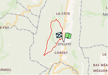
Ruta Senderismo de 10,4 km a descubrir en Auvergne-Rhône-Alpes, Isère, Rencurel. Esta ruta ha sido propuesta por pgeiger.
Descripción
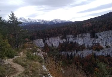
Promenade très accessible. Le passage par la grotte des fromages est accessible moins nous sommes passés en contrebas.
Localización
País:
France
Región :
Auvergne-Rhône-Alpes
Departamento/provincia :
Isère
Municipio :
Rencurel
Localidad:
Unknown
Salida:(Dec)
Salida:(UTM)
694573 ; 4997505 (31T) N.
Comentarios
Excursiones cerca
![Excursión Senderismo Châtelus - 38 bournillon porte du diable charmatte - Photo](https://media.geolcdn.com/t/375/260/d74c1d26-f2c4-4c87-8563-94950cba2a2c.jpg&format=jpg&maxdim=2)
![Senderismo Senderismo](https://static1.geolcdn.com/sitytour/trail-icons/101.png)
38 bournillon porte du diable charmatte
Senderismo
Difícil
(1)
Châtelus,
Auvergne-Rhône-Alpes,
Isère,
France
![](/images/other/stat-length.png)
16,5 km | 34 km-effort
8h 7min
![](https://static1.geolcdn.com/siteimages/upload/files/16400158638029165_repeat_loop_refresh_sync_direction_icon.png)
Sí
![Excursión Raquetas de nieve Autrans-Méaudre en Vercors - Le Gros Martel - Méaudre - Photo](https://media.geolcdn.com/t/375/260/ext.jpg?maxdim=2&url=https%3A%2F%2Fservices.sitytrail.com%2FGeolivesWS%2FDownloadMedia.ashx%3FTrailID%3D191341%26Media%3D14899_5.jpg)
![Raquetas de nieve Raquetas de nieve](https://static1.geolcdn.com/sitytour/trail-icons/504.png)
Le Gros Martel - Méaudre
Raquetas de nieve
Medio
(4)
Autrans-Méaudre en Vercors,
Auvergne-Rhône-Alpes,
Isère,
France
![](/images/other/stat-length.png)
4,9 km | 8,4 km-effort
2h 10min
![](https://static1.geolcdn.com/siteimages/upload/files/16400158638029165_repeat_loop_refresh_sync_direction_icon.png)
Sí
![Excursión Senderismo Rencurel - 38 vire bourne goule noire - Photo](https://media.geolcdn.com/t/375/260/62b6a30b-af4a-4e09-9d99-ed85f47fb4ae.jpg&format=jpg&maxdim=2)
![Senderismo Senderismo](https://static1.geolcdn.com/sitytour/trail-icons/101.png)
38 vire bourne goule noire
Senderismo
Medio
Rencurel,
Auvergne-Rhône-Alpes,
Isère,
France
![](/images/other/stat-length.png)
11,9 km | 24 km-effort
6h 44min
![](https://static1.geolcdn.com/siteimages/upload/files/16400158638029165_repeat_loop_refresh_sync_direction_icon.png)
Sí
![Excursión Senderismo Villard-de-Lans - crête de Ferrière et pas de Rages - Photo](https://media.geolcdn.com/t/375/260/366bd126-b053-4e11-9a71-f5b68c70d969.jpg&format=jpg&maxdim=2)
![Senderismo Senderismo](https://static1.geolcdn.com/sitytour/trail-icons/101.png)
crête de Ferrière et pas de Rages
Senderismo
Medio
Villard-de-Lans,
Auvergne-Rhône-Alpes,
Isère,
France
![](/images/other/stat-length.png)
13,5 km | 23 km-effort
6h 0min
![](https://static1.geolcdn.com/siteimages/upload/files/16400158638029165_repeat_loop_refresh_sync_direction_icon.png)
Sí
![Excursión A pie Rencurel - La Balme Noire par la vire de Haute Valette - Photo](https://media.geolcdn.com/t/375/260/ext.jpg?maxdim=2&url=https%3A%2F%2Fstatic1.geolcdn.com%2Fsiteimages%2Fupload%2Ffiles%2F1545311037marcheuse_200dpi.jpg)
![A pie A pie](https://static1.geolcdn.com/sitytour/trail-icons/100.png)
La Balme Noire par la vire de Haute Valette
A pie
Difícil
(1)
Rencurel,
Auvergne-Rhône-Alpes,
Isère,
France
![](/images/other/stat-length.png)
10,5 km | 21 km-effort
Desconocido
![](https://static1.geolcdn.com/siteimages/upload/files/16400158638029165_repeat_loop_refresh_sync_direction_icon.png)
Sí
![Excursión Senderismo Rencurel - 26 pas ferrière valchevriere - Photo](https://media.geolcdn.com/t/375/260/9dd39c24-ec71-4826-ac00-83cd7af45ed7.jpg&format=jpg&maxdim=2)
![Senderismo Senderismo](https://static1.geolcdn.com/sitytour/trail-icons/101.png)
26 pas ferrière valchevriere
Senderismo
Medio
Rencurel,
Auvergne-Rhône-Alpes,
Isère,
France
![](/images/other/stat-length.png)
14,6 km | 24 km-effort
6h 1min
![](https://static1.geolcdn.com/siteimages/upload/files/16400158638029165_repeat_loop_refresh_sync_direction_icon.png)
Sí
![Excursión Senderismo Châtelus - la grotte des Gaulois, le pas de l' Echarasson, porte du diable, pas de charmate - Photo](https://media.geolcdn.com/t/375/260/c1c947db-e815-4652-a05d-cf71b9e7231f.jpg&format=jpg&maxdim=2)
![Senderismo Senderismo](https://static1.geolcdn.com/sitytour/trail-icons/101.png)
la grotte des Gaulois, le pas de l' Echarasson, porte du diable, pas de charmate
Senderismo
Difícil
Châtelus,
Auvergne-Rhône-Alpes,
Isère,
France
![](/images/other/stat-length.png)
18,3 km | 37 km-effort
8h 23min
![](https://static1.geolcdn.com/siteimages/upload/files/16400158638029165_repeat_loop_refresh_sync_direction_icon.png)
Sí
![Excursión Senderismo Malleval-en-Vercors - pas du Follet en boucle - Photo](https://media.geolcdn.com/t/375/260/ext.jpg?maxdim=2&url=https%3A%2F%2Fstatic1.geolcdn.com%2Fsiteimages%2Fupload%2Ffiles%2F1553511878bg_sport_marche.png)
![Senderismo Senderismo](https://static1.geolcdn.com/sitytour/trail-icons/101.png)
pas du Follet en boucle
Senderismo
Medio
(1)
Malleval-en-Vercors,
Auvergne-Rhône-Alpes,
Isère,
France
![](/images/other/stat-length.png)
16,7 km | 26 km-effort
6h 59min
![](https://static1.geolcdn.com/siteimages/upload/files/16400158638029165_repeat_loop_refresh_sync_direction_icon.png)
Sí
![Excursión Senderismo Villard-de-Lans - Gorges de la Bourne - Photo](https://media.geolcdn.com/t/375/260/ext.jpg?maxdim=2&url=https%3A%2F%2Fstatic1.geolcdn.com%2Fsiteimages%2Fupload%2Ffiles%2F1553511878bg_sport_marche.png)
![Senderismo Senderismo](https://static1.geolcdn.com/sitytour/trail-icons/101.png)
Gorges de la Bourne
Senderismo
Fácil
(5)
Villard-de-Lans,
Auvergne-Rhône-Alpes,
Isère,
France
![](/images/other/stat-length.png)
5,5 km | 8,8 km-effort
2h 13min
![](https://static1.geolcdn.com/siteimages/upload/files/16400158638029165_repeat_loop_refresh_sync_direction_icon.png)
Sí