![](/images/other/stat-length.png)
![Excursión Senderismo Lasalle - Gard - Lasalle Ste-Ctoix-de-Caderle 11km 370m - Photo](https://media.geolcdn.com/t/1900/400/ext.pjpeg?maxdim=2&url=https%3A%2F%2Fstatic1.geolcdn.com%2Fsiteimages%2Fupload%2Ffiles%2F1553511878bg_sport_marche.png)
Gard - Lasalle Ste-Ctoix-de-Caderle 11km 370m
RandoVal
Usuario
![Longitud](/images/other/stat-length.png)
Longitud
11,7 km
![Altitud máxima](https://static1.geolcdn.com/siteimages/upload/files/1508320355ic_sort_altitude_max_24dp.png)
Altitud máxima
599 m
![Desnivel positivo](https://static1.geolcdn.com/siteimages/upload/files/1508320355ic_sort_den_pos_24dp.png)
Desnivel positivo
432 m
![Km-Effort](/images/other/stat-length.png)
Km-Effort
17,4 km
![Altitud mínima](https://static1.geolcdn.com/siteimages/upload/files/1508320355ic_sort_altitude_min_24dp.png)
Altitud mínima
278 m
![Desnivel negativo](https://static1.geolcdn.com/siteimages/upload/files/1508320355ic_sort_den_neg_24dp.png)
Desnivel negativo
434 m
![Boucle](https://static1.geolcdn.com/siteimages/upload/files/16400158638029165_repeat_loop_refresh_sync_direction_icon.png)
Boucle
Sí
Fecha de creación :
2020-08-09 06:35:07.102
Última modificación :
2020-08-10 11:26:10.392
![Senderismo](https://static1.geolcdn.com/sitytour/trail-icons/101.png)
--
Dificultad : Desconocido
![Escanee este código QR para abrir la excursión en la aplicación SityTrail](https://capi.geolives.com/qq0zvz2zws4bq2lad0pu/sitytour/trails/2507489/qr.png?size=200)
Aplicación GPS de excursión GRATIS
A propósito
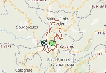
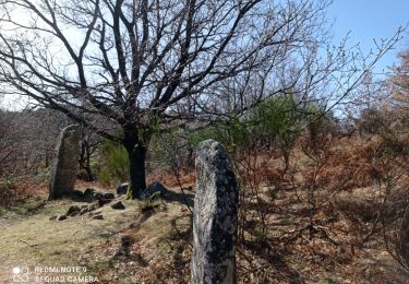
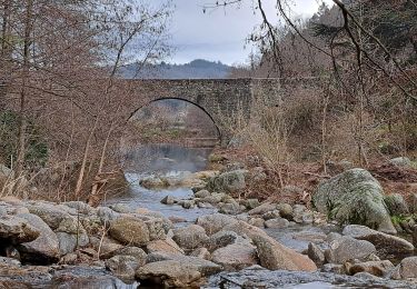
Ruta Senderismo de 11,7 km a descubrir en Occitania, Gard, Lasalle. Esta ruta ha sido propuesta por RandoVal.
Descripción
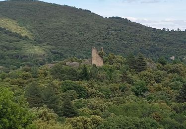
Boucle en Cévennes gardoise, départ et stationnement place de la mairie de Lasalle, sens anti-horaire. Beau point de vue à Ste-Croix-de-Caderle.
Localización
País:
France
Región :
Occitania
Departamento/provincia :
Gard
Municipio :
Lasalle
Localidad:
Unknown
Salida:(Dec)
Salida:(UTM)
568453 ; 4877257 (31T) N.
Comentarios
Excursiones cerca
![Excursión Senderismo Soudorgues - Vallée Salindrenque - Photo](https://media.geolcdn.com/t/375/260/ext.jpg?maxdim=2&url=https%3A%2F%2Fmedia.geolcdn.com%2Ff%2Fcdaa973a-fc3c-410e-b572-e43390419aac.jpg)
![Senderismo Senderismo](https://static1.geolcdn.com/sitytour/trail-icons/101.png)
Vallée Salindrenque
Senderismo
Difícil
Soudorgues,
Occitania,
Gard,
France
![](/images/other/stat-length.png)
19,4 km | 30 km-effort
6h 20min
![](https://static1.geolcdn.com/siteimages/upload/files/16400158638029165_repeat_loop_refresh_sync_direction_icon.png)
Sí
![Excursión Senderismo Lasalle - LASALLE - SAINTE-CROIX-DE-CADERLE – CALVIAC - 8.3Km - 02h30 - Dénivelé 352 m - Photo](https://media.geolcdn.com/t/375/260/ext.jpg?maxdim=2&url=https%3A%2F%2Fstatic1.geolcdn.com%2Fsiteimages%2Fupload%2Ffiles%2F1553511878bg_sport_marche.png)
![Senderismo Senderismo](https://static1.geolcdn.com/sitytour/trail-icons/101.png)
LASALLE - SAINTE-CROIX-DE-CADERLE – CALVIAC - 8.3Km - 02h30 - Dénivelé 352 m
Senderismo
Difícil
(1)
Lasalle,
Occitania,
Gard,
France
![](/images/other/stat-length.png)
12,8 km | 19,1 km-effort
3h 59min
![](https://static1.geolcdn.com/siteimages/upload/files/16400158638029165_repeat_loop_refresh_sync_direction_icon.png)
Sí
![Excursión A pie Colognac - 30 du Cayrel au Camp Barrat 20/02/24 - Photo](https://media.geolcdn.com/t/375/260/ext.jpg?maxdim=2&url=https%3A%2F%2Fmedia.geolcdn.com%2Ff%2Fdb46be15-0ade-41ce-a4c3-6381b880347f.jpg)
![A pie A pie](https://static1.geolcdn.com/sitytour/trail-icons/100.png)
30 du Cayrel au Camp Barrat 20/02/24
A pie
Medio
Colognac,
Occitania,
Gard,
France
![](/images/other/stat-length.png)
16 km | 25 km-effort
5h 38min
![](https://static1.geolcdn.com/siteimages/upload/files/16400158638029165_repeat_loop_refresh_sync_direction_icon.png)
Sí
![Excursión Senderismo Lasalle - Lasalle - Photo](https://media.geolcdn.com/t/375/260/ext.jpg?maxdim=2&url=https%3A%2F%2Fmedia.geolcdn.com%2Ff%2Ff5798f1a-39ae-4247-a0e3-4c9a96cfa841.jpg)
![Senderismo Senderismo](https://static1.geolcdn.com/sitytour/trail-icons/101.png)
![Excursión Senderismo Lasalle - LaSalle - Photo](https://media.geolcdn.com/t/375/260/ext.jpg?maxdim=2&url=https%3A%2F%2Fmedia.geolcdn.com%2Ff%2F7a654ce7-e102-4459-8e43-06423b1a0861.jpg)
![Senderismo Senderismo](https://static1.geolcdn.com/sitytour/trail-icons/101.png)
![Excursión Senderismo Lasalle - vallée Salindrenque autour de Lasalle - Photo](https://media.geolcdn.com/t/375/260/ext.jpg?maxdim=2&url=https%3A%2F%2Fmedia.geolcdn.com%2Ff%2Fa73dda74-f27d-4781-8977-cf2b7ac09d72.jpg)
![Senderismo Senderismo](https://static1.geolcdn.com/sitytour/trail-icons/101.png)
vallée Salindrenque autour de Lasalle
Senderismo
Medio
Lasalle,
Occitania,
Gard,
France
![](/images/other/stat-length.png)
13,3 km | 19,7 km-effort
5h 9min
![](https://static1.geolcdn.com/siteimages/upload/files/16400158638029165_repeat_loop_refresh_sync_direction_icon.png)
Sí
![Excursión Senderismo Lasalle - Lasalle Briontet Soudorgues - Photo](https://media.geolcdn.com/t/375/260/ext.jpg?maxdim=2&url=https%3A%2F%2Fmedia.geolcdn.com%2Ff%2F5b91dd5c-c108-441f-978c-27e5c1cdfc14.jpg)
![Senderismo Senderismo](https://static1.geolcdn.com/sitytour/trail-icons/101.png)
Lasalle Briontet Soudorgues
Senderismo
Difícil
Lasalle,
Occitania,
Gard,
France
![](/images/other/stat-length.png)
17,9 km | 29 km-effort
5h 32min
![](https://static1.geolcdn.com/siteimages/upload/files/16400158638029165_repeat_loop_refresh_sync_direction_icon.png)
Sí
![Excursión Senderismo Lasalle - LaSalle - Photo](https://media.geolcdn.com/t/375/260/ext.jpg?maxdim=2&url=https%3A%2F%2Fmedia.geolcdn.com%2Ff%2F3f59843b-f661-40ba-b48a-238c1f08d391.jpg)
![Senderismo Senderismo](https://static1.geolcdn.com/sitytour/trail-icons/101.png)
![Excursión Senderismo Soudorgues - La Vallée Borgne - Photo](https://media.geolcdn.com/t/375/260/ext.jpg?maxdim=2&url=https%3A%2F%2Fmedia.geolcdn.com%2Ff%2Ffc66911e-f8e1-402c-a199-faceb474f5bb.jpg)
![Senderismo Senderismo](https://static1.geolcdn.com/sitytour/trail-icons/101.png)
La Vallée Borgne
Senderismo
Difícil
Soudorgues,
Occitania,
Gard,
France
![](/images/other/stat-length.png)
14,6 km | 22 km-effort
5h 30min
![](https://static1.geolcdn.com/siteimages/upload/files/16400158638029165_repeat_loop_refresh_sync_direction_icon.png)
Sí