![](/images/other/stat-length.png)
![Excursión Raquetas de nieve Bellevaux - Lac de Pététoz - Photo](https://media.geolcdn.com/t/1900/400/ext.pjpeg?maxdim=2&url=https%3A%2F%2Fservices.sitytrail.com%2FGeolivesWS%2FDownloadMedia.ashx%3FTrailID%3D1116113%26Media%3D20190226123552.jpg)
Lac de Pététoz
petole
Usuario
![Longitud](/images/other/stat-length.png)
Longitud
6,2 km
![Altitud máxima](https://static1.geolcdn.com/siteimages/upload/files/1508320355ic_sort_altitude_max_24dp.png)
Altitud máxima
1567 m
![Desnivel positivo](https://static1.geolcdn.com/siteimages/upload/files/1508320355ic_sort_den_pos_24dp.png)
Desnivel positivo
417 m
![Km-Effort](/images/other/stat-length.png)
Km-Effort
11,9 km
![Altitud mínima](https://static1.geolcdn.com/siteimages/upload/files/1508320355ic_sort_altitude_min_24dp.png)
Altitud mínima
1134 m
![Desnivel negativo](https://static1.geolcdn.com/siteimages/upload/files/1508320355ic_sort_den_neg_24dp.png)
Desnivel negativo
441 m
![Boucle](https://static1.geolcdn.com/siteimages/upload/files/16400158638029165_repeat_loop_refresh_sync_direction_icon.png)
Boucle
Sí
Fecha de creación :
2019-03-31 17:48:53.31
Última modificación :
2019-03-31 17:48:53.31
![Raquetas de nieve](https://static1.geolcdn.com/sitytour/trail-icons/504.png)
2h32
Dificultad : Difícil
![Escanee este código QR para abrir la excursión en la aplicación SityTrail](https://capi.geolives.com/qq0zvz2zws4bq2lad0pu/sitytour/trails/1116113/qr.png?size=200)
Aplicación GPS de excursión GRATIS
A propósito
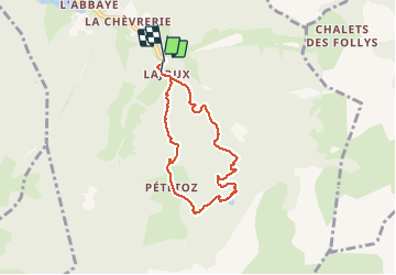
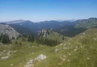
Ruta Raquetas de nieve de 6,2 km a descubrir en Auvergne-Rhône-Alpes, Alta Saboya, Bellevaux. Esta ruta ha sido propuesta por petole.
Descripción
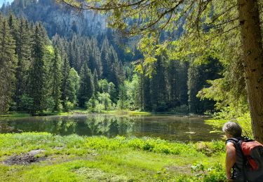
Circuit facile jusqu'au pied du lac suivi de 10 minutes en aval et de 20 en amont du lac d'une zone raide et technique sur terrain mixte en sous-bois. A privilégier par neige dure.
Localización
País:
France
Región :
Auvergne-Rhône-Alpes
Departamento/provincia :
Alta Saboya
Municipio :
Bellevaux
Localidad:
Unknown
Salida:(Dec)
Salida:(UTM)
313048 ; 5119958 (32T) N.
Comentarios
Excursiones cerca
![Excursión Marcha nórdica Bellevaux - tour du roc - Photo](https://media.geolcdn.com/t/375/260/ext.jpg?maxdim=2&url=https%3A%2F%2Fservices.sitytrail.com%2FGeolivesWS%2FDownloadMedia.ashx%3FTrailID%3D168665%26Media%3D20130105113055.jpeg)
![Marcha nórdica Marcha nórdica](https://static1.geolcdn.com/sitytour/trail-icons/102.png)
tour du roc
Marcha nórdica
Medio
(1)
Bellevaux,
Auvergne-Rhône-Alpes,
Alta Saboya,
France
![](/images/other/stat-length.png)
26 km | 53 km-effort
4h 7min
![](https://static1.geolcdn.com/siteimages/upload/files/16400158638029165_repeat_loop_refresh_sync_direction_icon.png)
Sí
![Excursión Senderismo Bellevaux - La Haute Pointe 1968m, depuis le Plan des Rasses - Photo](https://media.geolcdn.com/t/375/260/ext.jpg?maxdim=2&url=https%3A%2F%2Fservices.sitytrail.com%2FGeolivesWS%2FDownloadMedia.ashx%3FTrailID%3D316834%26Media%3D15897_1.jpg)
![Senderismo Senderismo](https://static1.geolcdn.com/sitytour/trail-icons/101.png)
La Haute Pointe 1968m, depuis le Plan des Rasses
Senderismo
Medio
(1)
Bellevaux,
Auvergne-Rhône-Alpes,
Alta Saboya,
France
![](/images/other/stat-length.png)
9,8 km | 21 km-effort
5h 30min
![](https://static1.geolcdn.com/siteimages/upload/files/16400158638029165_repeat_loop_refresh_sync_direction_icon.png)
Sí
![Excursión Senderismo Mieussy - La Pointe de Chavasse, 2012m - Photo](https://media.geolcdn.com/t/375/260/ext.jpg?maxdim=2&url=https%3A%2F%2Fservices.sitytrail.com%2FGeolivesWS%2FDownloadMedia.ashx%3FTrailID%3D172620%26Media%3D13985_1.jpg)
![Senderismo Senderismo](https://static1.geolcdn.com/sitytour/trail-icons/101.png)
La Pointe de Chavasse, 2012m
Senderismo
Difícil
(1)
Mieussy,
Auvergne-Rhône-Alpes,
Alta Saboya,
France
![](/images/other/stat-length.png)
9,9 km | 18,2 km-effort
4h 45min
![](https://static1.geolcdn.com/siteimages/upload/files/16400158638029165_repeat_loop_refresh_sync_direction_icon.png)
Sí
![Excursión Senderismo Bellevaux - Pointe d'Ireuse - Photo](https://media.geolcdn.com/t/375/260/ext.jpg?maxdim=2&url=https%3A%2F%2Fstatic1.geolcdn.com%2Fsiteimages%2Fupload%2Ffiles%2F1553511878bg_sport_marche.png)
![Senderismo Senderismo](https://static1.geolcdn.com/sitytour/trail-icons/101.png)
Pointe d'Ireuse
Senderismo
Medio
(2)
Bellevaux,
Auvergne-Rhône-Alpes,
Alta Saboya,
France
![](/images/other/stat-length.png)
11,3 km | 23 km-effort
5h 47min
![](https://static1.geolcdn.com/siteimages/upload/files/16400158638029165_repeat_loop_refresh_sync_direction_icon.png)
Sí
![Excursión Senderismo Taninges - Balade autour de Beauregard - Photo](https://media.geolcdn.com/t/375/260/b9aaba51-d4ef-43fe-903b-7522c0326849.jpg&format=jpg&maxdim=2)
![Senderismo Senderismo](https://static1.geolcdn.com/sitytour/trail-icons/101.png)
Balade autour de Beauregard
Senderismo
Medio
Taninges,
Auvergne-Rhône-Alpes,
Alta Saboya,
France
![](/images/other/stat-length.png)
5,9 km | 10,5 km-effort
1h 39min
![](https://static1.geolcdn.com/siteimages/upload/files/16400158638029165_repeat_loop_refresh_sync_direction_icon.png)
Sí
![Excursión Senderismo Mieussy - le tour de la haute pointe - Photo](https://media.geolcdn.com/t/375/260/6384457b-18fc-4356-9b38-d58a4cfbdf11.jpg&format=jpg&maxdim=2)
![Senderismo Senderismo](https://static1.geolcdn.com/sitytour/trail-icons/101.png)
le tour de la haute pointe
Senderismo
Medio
Mieussy,
Auvergne-Rhône-Alpes,
Alta Saboya,
France
![](/images/other/stat-length.png)
6,4 km | 12,7 km-effort
3h 38min
![](https://static1.geolcdn.com/siteimages/upload/files/16400158638029165_repeat_loop_refresh_sync_direction_icon.png)
Sí
![Excursión Senderismo Mieussy - CHABLAIS: TOUR DE LA POINTE DE CHALUNE - Photo](https://media.geolcdn.com/t/375/260/32569742-e5b7-4156-9721-a914bf03f96e.jpg&format=jpg&maxdim=2)
![Senderismo Senderismo](https://static1.geolcdn.com/sitytour/trail-icons/101.png)
CHABLAIS: TOUR DE LA POINTE DE CHALUNE
Senderismo
Medio
Mieussy,
Auvergne-Rhône-Alpes,
Alta Saboya,
France
![](/images/other/stat-length.png)
12,2 km | 23 km-effort
5h 0min
![](https://static1.geolcdn.com/siteimages/upload/files/16400158638029165_repeat_loop_refresh_sync_direction_icon.png)
Sí
![Excursión Senderismo Mieussy - CHABLAIS: COLS CHALUNE - VESINAZ - Photo](https://media.geolcdn.com/t/375/260/a77ba278-7b9d-496e-81c3-caca4c1536a4.jpg&format=jpg&maxdim=2)
![Senderismo Senderismo](https://static1.geolcdn.com/sitytour/trail-icons/101.png)
CHABLAIS: COLS CHALUNE - VESINAZ
Senderismo
Fácil
Mieussy,
Auvergne-Rhône-Alpes,
Alta Saboya,
France
![](/images/other/stat-length.png)
6,4 km | 12 km-effort
2h 45min
![](https://static1.geolcdn.com/siteimages/upload/files/16400158638029165_repeat_loop_refresh_sync_direction_icon.png)
Sí
![Excursión Senderismo Bellevaux - 2021-10-15 La Pointe de La Gay - Photo](https://media.geolcdn.com/t/375/260/7b0efd93-8b0c-4d5f-a9c8-7f3d48655447.jpg&format=jpg&maxdim=2)
![Senderismo Senderismo](https://static1.geolcdn.com/sitytour/trail-icons/101.png)
2021-10-15 La Pointe de La Gay
Senderismo
Medio
Bellevaux,
Auvergne-Rhône-Alpes,
Alta Saboya,
France
![](/images/other/stat-length.png)
11,2 km | 21 km-effort
5h 5min
![](https://static1.geolcdn.com/siteimages/upload/files/16400158638029165_repeat_loop_refresh_sync_direction_icon.png)
Sí