![](/images/other/stat-length.png)
![Trail Walking La Baume-Cornillane - Pas du Pont - Pas de la Croix - Pas du Buis - Photo](https://media.geolcdn.com/t/1900/400/ext.pjpeg?maxdim=2&url=https%3A%2F%2Fservices.sitytrail.com%2FGeolivesWS%2FDownloadMedia.ashx%3FTrailID%3D99687%26Media%3D20120128162324.jpeg)
Pas du Pont - Pas de la Croix - Pas du Buis
patbt
User
![Length](/images/other/stat-length.png)
Length
10.3 km
![Max alt](https://static1.geolcdn.com/siteimages/upload/files/1508320355ic_sort_altitude_max_24dp.png)
Max alt
882 m
![Uphill gradient](https://static1.geolcdn.com/siteimages/upload/files/1508320355ic_sort_den_pos_24dp.png)
Uphill gradient
573 m
![Km-Effort](/images/other/stat-length.png)
Km-Effort
18 km
![Min alt](https://static1.geolcdn.com/siteimages/upload/files/1508320355ic_sort_altitude_min_24dp.png)
Min alt
318 m
![Downhill gradient](https://static1.geolcdn.com/siteimages/upload/files/1508320355ic_sort_den_neg_24dp.png)
Downhill gradient
565 m
![Boucle](https://static1.geolcdn.com/siteimages/upload/files/16400158638029165_repeat_loop_refresh_sync_direction_icon.png)
Boucle
Yes
Creation date :
2014-12-10 00:00:00.0
Updated on :
2014-12-10 00:00:00.0
![Walking](https://static1.geolcdn.com/sitytour/trail-icons/101.png)
2h52
Difficulty : Medium
![Scan this QR Code to open this trail in the SityTrail application](https://capi.geolives.com/qq0zvz2zws4bq2lad0pu/sitytour/trails/99687/qr.png?size=200)
FREE GPS app for hiking
About
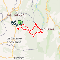
Trail Walking of 10.3 km to be discovered at Auvergne-Rhône-Alpes, Drôme, La Baume-Cornillane. This trail is proposed by patbt.
Description
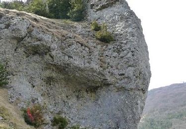
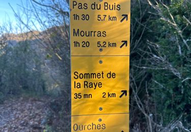
Le départ se fait en laissant son véhicule au Pas du Pont à La Baume Cornillane. Il passe en crête entre le Pas de la Croix et le Pas du Buis.
Positioning
Country:
France
Region :
Auvergne-Rhône-Alpes
Department/Province :
Drôme
Municipality :
La Baume-Cornillane
Location:
Unknown
Start:(Dec)
Start:(UTM)
661567 ; 4966733 (31T) N.
Comments
Trails nearby
![Trail Walking Barcelonne - Barcelonne - autour de la Tour - Description et photos - Photo](https://media.geolcdn.com/t/375/260/ext.jpg?maxdim=2&url=https%3A%2F%2Fservices.sitytrail.com%2FGeolivesWS%2FDownloadMedia.ashx%3FTrailID%3D639966%26Media%3Dfix__20161002163239.jpg)
![Walking Walking](https://static1.geolcdn.com/sitytour/trail-icons/101.png)
Barcelonne - autour de la Tour - Description et photos
Walking
Easy
(3)
Barcelonne,
Auvergne-Rhône-Alpes,
Drôme,
France
![](/images/other/stat-length.png)
4.3 km | 6.6 km-effort
1h 29min
![](https://static1.geolcdn.com/siteimages/upload/files/16400158638029165_repeat_loop_refresh_sync_direction_icon.png)
Yes
![Trail Walking Gigors-et-Lozeron - St Supière et Savel à Gigors et Lozeron - Photo](https://media.geolcdn.com/t/375/260/ext.jpg?maxdim=2&url=https%3A%2F%2Fservices.sitytrail.com%2FGeolivesWS%2FDownloadMedia.ashx%3FTrailID%3D103208%26Media%3D5080_3.jpg)
![Walking Walking](https://static1.geolcdn.com/sitytour/trail-icons/101.png)
St Supière et Savel à Gigors et Lozeron
Walking
Difficult
(1)
Gigors-et-Lozeron,
Auvergne-Rhône-Alpes,
Drôme,
France
![](/images/other/stat-length.png)
11.2 km | 17.9 km-effort
4h 0min
![](https://static1.geolcdn.com/siteimages/upload/files/16400158638029165_repeat_loop_refresh_sync_direction_icon.png)
Yes
![Trail Walking Barcelonne - Barcelonne-Combivin-Chapelle St Marguerite - Photo](https://media.geolcdn.com/t/375/260/ext.jpg?maxdim=2&url=https%3A%2F%2Fservices.sitytrail.com%2FGeolivesWS%2FDownloadMedia.ashx%3FTrailID%3D272339%26Media%3D20140430171101.jpg)
![Walking Walking](https://static1.geolcdn.com/sitytour/trail-icons/101.png)
Barcelonne-Combivin-Chapelle St Marguerite
Walking
Easy
(1)
Barcelonne,
Auvergne-Rhône-Alpes,
Drôme,
France
![](/images/other/stat-length.png)
8.7 km | 13.5 km-effort
2h 20min
![](https://static1.geolcdn.com/siteimages/upload/files/16400158638029165_repeat_loop_refresh_sync_direction_icon.png)
Yes
![Trail Walking Gigors-et-Lozeron - 26 st supporte gigors - Photo](https://media.geolcdn.com/t/375/260/c169c5cd-1ed9-4b41-908c-c962ab944e47.jpg&format=jpg&maxdim=2)
![Walking Walking](https://static1.geolcdn.com/sitytour/trail-icons/101.png)
26 st supporte gigors
Walking
Medium
Gigors-et-Lozeron,
Auvergne-Rhône-Alpes,
Drôme,
France
![](/images/other/stat-length.png)
16 km | 24 km-effort
5h 8min
![](https://static1.geolcdn.com/siteimages/upload/files/16400158638029165_repeat_loop_refresh_sync_direction_icon.png)
Yes
![Trail Walking La Baume-Cornillane - pas du pont - Photo](https://media.geolcdn.com/t/375/260/ext.jpg?maxdim=2&url=https%3A%2F%2Fstatic1.geolcdn.com%2Fsiteimages%2Fupload%2Ffiles%2F1553511878bg_sport_marche.png)
![Walking Walking](https://static1.geolcdn.com/sitytour/trail-icons/101.png)
pas du pont
Walking
Easy
(1)
La Baume-Cornillane,
Auvergne-Rhône-Alpes,
Drôme,
France
![](/images/other/stat-length.png)
6.9 km | 9.8 km-effort
3h 22min
![](https://static1.geolcdn.com/siteimages/upload/files/16400158638029165_repeat_loop_refresh_sync_direction_icon.png)
Yes
![Trail sport La Baume-Cornillane - La Baume Cornillane La Raye - Photo](https://media.geolcdn.com/t/375/260/7f63db71-820f-4a5b-bce7-d0b5098b2eb0.jpg&format=jpg&maxdim=2)
La Baume Cornillane La Raye
sport
Very easy
La Baume-Cornillane,
Auvergne-Rhône-Alpes,
Drôme,
France
![](/images/other/stat-length.png)
15.5 km | 27 km-effort
Unknown
![](https://static1.geolcdn.com/siteimages/upload/files/16400158638029165_repeat_loop_refresh_sync_direction_icon.png)
Yes
![Trail sport Ourches - Ourches Cobonne col croix Bezot - Photo](https://media.geolcdn.com/t/375/260/c1f74f9b-903b-45f4-9039-e55a97ca2dd5.jpg&format=jpg&maxdim=2)
Ourches Cobonne col croix Bezot
sport
Very easy
Ourches,
Auvergne-Rhône-Alpes,
Drôme,
France
![](/images/other/stat-length.png)
18.8 km | 32 km-effort
Unknown
![](https://static1.geolcdn.com/siteimages/upload/files/16400158638029165_repeat_loop_refresh_sync_direction_icon.png)
Yes
![Trail Road bike Barcelonne - 03-05-22-14693810 - Photo](https://media.geolcdn.com/t/375/260/ext.jpg?maxdim=2&url=https%3A%2F%2Fstatic1.geolcdn.com%2Fsiteimages%2Fupload%2Ffiles%2F1524743154velo.jpg)
![Road bike Road bike](https://static1.geolcdn.com/sitytour/trail-icons/201.png)
03-05-22-14693810
Road bike
Very difficult
(1)
Barcelonne,
Auvergne-Rhône-Alpes,
Drôme,
France
![](/images/other/stat-length.png)
67 km | 88 km-effort
5h 20min
![](https://static1.geolcdn.com/siteimages/upload/files/16400158638029165_repeat_loop_refresh_sync_direction_icon.png)
No
![Trail Walking Combovin - COMBOVIN 2023 - Photo](https://media.geolcdn.com/t/375/260/9fc4d486-081f-4035-b6ba-32d08b6cde19.jpg&format=jpg&maxdim=2)
![Walking Walking](https://static1.geolcdn.com/sitytour/trail-icons/101.png)
COMBOVIN 2023
Walking
Medium
Combovin,
Auvergne-Rhône-Alpes,
Drôme,
France
![](/images/other/stat-length.png)
15.4 km | 23 km-effort
5h 20min
![](https://static1.geolcdn.com/siteimages/upload/files/16400158638029165_repeat_loop_refresh_sync_direction_icon.png)
No
bien