![](/images/other/stat-length.png)
![Trail Walking Lepuix - wissgrutt cascade - Photo](https://media.geolcdn.com/t/1900/400/ext.pjpeg?maxdim=2&url=https%3A%2F%2Fstatic1.geolcdn.com%2Fsiteimages%2Fupload%2Ffiles%2F1553511878bg_sport_marche.png)
wissgrutt cascade
benoit747
User
![Length](/images/other/stat-length.png)
Length
10.4 km
![Max alt](https://static1.geolcdn.com/siteimages/upload/files/1508320355ic_sort_altitude_max_24dp.png)
Max alt
1119 m
![Uphill gradient](https://static1.geolcdn.com/siteimages/upload/files/1508320355ic_sort_den_pos_24dp.png)
Uphill gradient
571 m
![Km-Effort](/images/other/stat-length.png)
Km-Effort
18 km
![Min alt](https://static1.geolcdn.com/siteimages/upload/files/1508320355ic_sort_altitude_min_24dp.png)
Min alt
611 m
![Downhill gradient](https://static1.geolcdn.com/siteimages/upload/files/1508320355ic_sort_den_neg_24dp.png)
Downhill gradient
570 m
![Boucle](https://static1.geolcdn.com/siteimages/upload/files/16400158638029165_repeat_loop_refresh_sync_direction_icon.png)
Boucle
Yes
Creation date :
2018-06-26 16:32:58.19
Updated on :
2018-12-03 09:20:35.258
![Walking](https://static1.geolcdn.com/sitytour/trail-icons/101.png)
3h52
Difficulty : Unknown
![Scan this QR Code to open this trail in the SityTrail application](https://capi.geolives.com/qq0zvz2zws4bq2lad0pu/sitytour/trails/988277/qr.png?size=200)
FREE GPS app for hiking
About
Trail Walking of 10.4 km to be discovered at Bourgogne-Franche-Comté, Territoire-de-Belfort, Lepuix. This trail is proposed by benoit747.
Description
une rando pas trop longue mais au dénivellé plutôt conséquent.
Réalisable sur grosse 1/2 journée
possibilité de manger à l'auberge du wissgrutt
Positioning
Country:
France
Region :
Bourgogne-Franche-Comté
Department/Province :
Territoire-de-Belfort
Municipality :
Lepuix
Location:
Unknown
Start:(Dec)
Start:(UTM)
338913 ; 5296408 (32T) N.
Comments
Trails nearby
![Trail Walking Saint-Maurice-sur-Moselle - Tour du Ballon d'Alsace - Photo](https://media.geolcdn.com/t/375/260/ext.jpg?maxdim=2&url=https%3A%2F%2Fservices.sitytrail.com%2FGeolivesWS%2FDownloadMedia.ashx%3FTrailID%3D450011%26Media%3Dfix__20150716161020.jpg)
![Walking Walking](https://static1.geolcdn.com/sitytour/trail-icons/101.png)
Tour du Ballon d'Alsace
Walking
Difficult
(1)
Saint-Maurice-sur-Moselle,
Grand Est,
Vosges,
France
![](/images/other/stat-length.png)
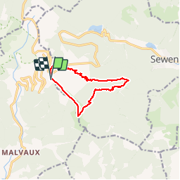
10.5 km | 17.7 km-effort
5h 25min
![](https://static1.geolcdn.com/siteimages/upload/files/16400158638029165_repeat_loop_refresh_sync_direction_icon.png)
Yes
![Trail Walking Sewen - Boucle entre les lacs de Sewen et d'Alfeld - Photo](https://media.geolcdn.com/t/375/260/ext.jpg?maxdim=2&url=https%3A%2F%2Fservices.sitytrail.com%2FGeolivesWS%2FDownloadMedia.ashx%3FTrailID%3D103686%26Media%3D6168_4.jpg)
![Walking Walking](https://static1.geolcdn.com/sitytour/trail-icons/101.png)
Boucle entre les lacs de Sewen et d'Alfeld
Walking
Medium
(1)
Sewen,
Grand Est,
Haut-Rhin,
France
![](/images/other/stat-length.png)
8.1 km | 12.3 km-effort
2h 30min
![](https://static1.geolcdn.com/siteimages/upload/files/16400158638029165_repeat_loop_refresh_sync_direction_icon.png)
Yes
![Trail Walking Sewen - lac d'Alfeld - Photo](https://media.geolcdn.com/t/375/260/f10be3b8-650f-4f78-b860-6c956e66a815.jpg&format=jpg&maxdim=2)
![Walking Walking](https://static1.geolcdn.com/sitytour/trail-icons/101.png)
lac d'Alfeld
Walking
Very difficult
(1)
Sewen,
Grand Est,
Haut-Rhin,
France
![](/images/other/stat-length.png)
17.1 km | 28 km-effort
8h 7min
![](https://static1.geolcdn.com/siteimages/upload/files/16400158638029165_repeat_loop_refresh_sync_direction_icon.png)
Yes
![Trail Walking Lepuix - Le Tremontkopf - Photo](https://media.geolcdn.com/t/375/260/ext.jpg?maxdim=2&url=https%3A%2F%2Fservices.sitytrail.com%2FGeolivesWS%2FDownloadMedia.ashx%3FTrailID%3D109649%26Media%3D4290_1.jpg)
![Walking Walking](https://static1.geolcdn.com/sitytour/trail-icons/101.png)
Le Tremontkopf
Walking
Medium
(1)
Lepuix,
Bourgogne-Franche-Comté,
Territoire-de-Belfort,
France
![](/images/other/stat-length.png)
9.1 km | 17.3 km-effort
3h 0min
![](https://static1.geolcdn.com/siteimages/upload/files/16400158638029165_repeat_loop_refresh_sync_direction_icon.png)
Yes
![Trail Walking Plancher-les-Mines - 2025-01-04 Rando Polaire Dolleren Ballon Alsace Etape 3 - Photo](https://media.geolcdn.com/t/375/260/2540e417-a017-45ca-bf10-302bab8725fa.jpg&format=jpg&maxdim=2)
![Walking Walking](https://static1.geolcdn.com/sitytour/trail-icons/101.png)
2025-01-04 Rando Polaire Dolleren Ballon Alsace Etape 3
Walking
Very difficult
Plancher-les-Mines,
Bourgogne-Franche-Comté,
Haute-Saône,
France
![](/images/other/stat-length.png)
18.6 km | 30 km-effort
6h 52min
![](https://static1.geolcdn.com/siteimages/upload/files/16400158638029165_repeat_loop_refresh_sync_direction_icon.png)
No
![Trail Walking Dolleren - 2025-01-03 Rando Polaire Dolleren Ballon Alsace Etape 2 - Photo](https://media.geolcdn.com/t/375/260/9acfce3f-2eaf-4a63-8eb3-62065bd107c3.jpg&format=jpg&maxdim=2)
![Walking Walking](https://static1.geolcdn.com/sitytour/trail-icons/101.png)
2025-01-03 Rando Polaire Dolleren Ballon Alsace Etape 2
Walking
Very difficult
Dolleren,
Grand Est,
Haut-Rhin,
France
![](/images/other/stat-length.png)
17.3 km | 26 km-effort
6h 0min
![](https://static1.geolcdn.com/siteimages/upload/files/16400158638029165_repeat_loop_refresh_sync_direction_icon.png)
No
![Trail Walking Servance-Miellin - 2019-08-06 Marche Ballon Servance Ballon Alsace - Photo](https://media.geolcdn.com/t/375/260/452d83b8-7651-47fa-bbef-bff585b94030.jpg&format=jpg&maxdim=2)
![Walking Walking](https://static1.geolcdn.com/sitytour/trail-icons/101.png)
2019-08-06 Marche Ballon Servance Ballon Alsace
Walking
Very difficult
Servance-Miellin,
Bourgogne-Franche-Comté,
Haute-Saône,
France
![](/images/other/stat-length.png)
19.9 km | 31 km-effort
6h 23min
![](https://static1.geolcdn.com/siteimages/upload/files/16400158638029165_repeat_loop_refresh_sync_direction_icon.png)
Yes
![Trail Walking Saint-Maurice-sur-Moselle - le lac des roseaux - Photo](https://media.geolcdn.com/t/375/260/ext.jpg?maxdim=2&url=https%3A%2F%2Fservices.sitytrail.com%2FGeolivesWS%2FDownloadMedia.ashx%3FTrailID%3D489792%26Media%3D455bc21e-67b8-4bf5-be66-0e90e9e8ca9a.jpg)
![Walking Walking](https://static1.geolcdn.com/sitytour/trail-icons/101.png)
le lac des roseaux
Walking
Medium
Saint-Maurice-sur-Moselle,
Grand Est,
Vosges,
France
![](/images/other/stat-length.png)
11.1 km | 17.6 km-effort
3h 35min
![](https://static1.geolcdn.com/siteimages/upload/files/16400158638029165_repeat_loop_refresh_sync_direction_icon.png)
No
![Trail Walking Lepuix - ballon alsace saut de la truite - Photo](https://media.geolcdn.com/t/375/260/ext.jpg?maxdim=2&url=https%3A%2F%2Fservices.sitytrail.com%2FGeolivesWS%2FDownloadMedia.ashx%3FTrailID%3D40878%26Media%3Dimage6.jpg)
![Walking Walking](https://static1.geolcdn.com/sitytour/trail-icons/101.png)
ballon alsace saut de la truite
Walking
Very easy
(1)
Lepuix,
Bourgogne-Franche-Comté,
Territoire-de-Belfort,
France
![](/images/other/stat-length.png)
9.2 km | 15.5 km-effort
3h 31min
![](https://static1.geolcdn.com/siteimages/upload/files/16400158638029165_repeat_loop_refresh_sync_direction_icon.png)
Yes