Trail Walking Aspres-sur-Buëch - du gîte ONF de Recours au gîte ONF de Rabioux - Photo

du gîte ONF de Recours au gîte ONF de Rabioux

 destras
destras

User

© OpenStreetMap contributors
Length
Length
15.3 km
Max alt
Max alt
1759 m
Uphill gradient
Uphill gradient
737 m
Km-Effort
Km-Effort  
25 km
Min alt
Min alt
1231 m
Downhill gradient
Downhill gradient
761 m
Boucle
Boucle
No
Creation date :
2018-06-26 16:27:03.187
Updated on :
2018-06-26 16:27:03.187

(0 Reviews)

Walking
Walking
4h40
Difficulty : Medium

Scan this QR Code to open this trail in the SityTrail application

FREE GPS app for hiking

Logo SityTrail SityTrail

IGN / Geographical institutes

Download SityTrail from the App Store Download SityTrail from Google Play

Logo SityTrail SityTrail World

The world is yours!

Download SityTrail from the App Store Download SityTrail from Google Play Download SityTrail on Huawei AppGallery

About

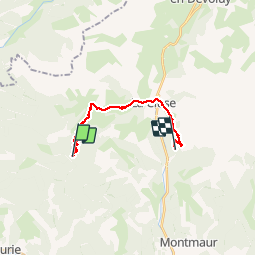
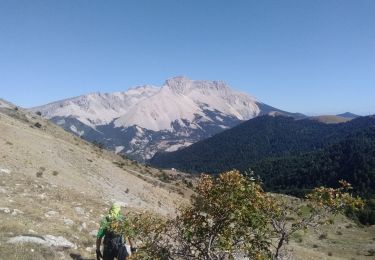
Trail Walking of 15.3 km to be discovered at Provence-Alpes-Côte d'Azur, Hautes-Alpes, Aspres-sur-Buëch. This trail is proposed by destras.

Description

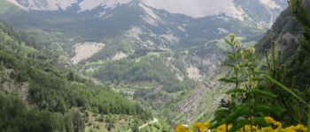
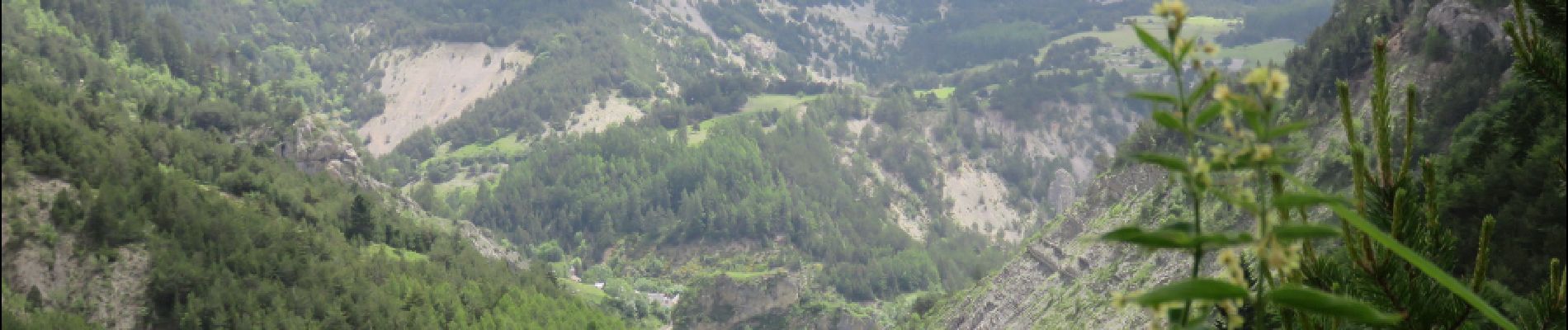
…par le col du Lauteret et le col du grand vallon. Les plus courageux monteront au col de Plate Contier très proche. Descente jusqu’à la Cluse en Dévoluy à travers des pâturages d’altitude. Arrivée à Rabioux en longeant le pierrier de la montagne d’Aurouze (un des plus grand d’Europe).

Elevation profile

Photos

Points of interest

Point of interest Le Dévoluy - Cityse - Photo
destras
LE DÉVOLUY 
Point of interest Le Dévoluy - Aurouze - Photo
destras
LE DÉVOLUY 

Positioning

Country:
France
Region :
Provence-Alpes-Côte d'Azur
Department/Province :
Hautes-Alpes
Municipality :
Aspres-sur-Buëch
Location:
Unknown
Start:(UTM)
721595 ; 4943761 (31T) N.

Trails nearby

Trail Walking Veynes - Charajaille - Photo
Walking
GUIDE
Marco05

Walking

Difficult
(1)
Veynes, Provence-Alpes-Côte d'Azur, Hautes-Alpes, France
8.1 km | 16.2 km-effort
3h 41min
Yes
Trail Walking Le Dévoluy - R13   Le Col de Lauteret - Photo
Walking
GUIDE+

Walking

Medium
(1)
Le Dévoluy, Provence-Alpes-Côte d'Azur, Hautes-Alpes, France
8.5 km | 15.9 km-effort
3h 12min
Yes
Trail Walking Le Dévoluy - suuntoapp-Hiking-2024-06-17T07-23-45Z - Photo
Walking
GUIDE
Marco05

Walking

Difficult
Le Dévoluy, Provence-Alpes-Côte d'Azur, Hautes-Alpes, France
9.6 km | 17.9 km-effort
4h 4min
Yes
Trail Walking Saint-Julien-en-Beauchêne - Chamousset - Photo
Walking
GUIDE
Marco05

Walking

Difficult
Saint-Julien-en-Beauchêne, Provence-Alpes-Côte d'Azur, Hautes-Alpes, France
11.2 km | 22 km-effort
5h 1min
Yes
Trail Walking Le Dévoluy - Tête de Garnesier - Photo
Walking
GUIDE
Marco05

Walking

Very difficult
Le Dévoluy, Provence-Alpes-Côte d'Azur, Hautes-Alpes, France
11.5 km | 26 km-effort
5h 57min
Yes
Trail Walking Le Dévoluy - Maniboux - Photo
Walking
GUIDE
Marco05

Walking

Medium
Le Dévoluy, Provence-Alpes-Côte d'Azur, Hautes-Alpes, France
10.9 km | 16.9 km-effort
3h 49min
Yes
Trail On foot Aspres-sur-Buëch - 9587028 - Photo
On foot
GUIDE+

On foot

Easy
Aspres-sur-Buëch, Provence-Alpes-Côte d'Azur, Hautes-Alpes, France
3.4 km | 5.3 km-effort
1h 12min
Yes
Trail Touring skiing Le Dévoluy - la combe de la Cluse et sommet 2595 - Photo
Touring skiing
GUIDE
nadd73

Touring skiing

Difficult
Le Dévoluy, Provence-Alpes-Côte d'Azur, Hautes-Alpes, France
13.9 km | 31 km-effort
7h 35min
Yes
Trail Walking Le Dévoluy - tête de Ganesier - Photo
Walking
GUIDE
nadd73

Walking

Medium
Le Dévoluy, Provence-Alpes-Côte d'Azur, Hautes-Alpes, France
11.9 km | 26 km-effort
6h 6min
Yes


Close
My subscriptions