Trail Other activity Abeilhan - RANDONNEE DE LA THONGUE ET SES COTEAUX - Photo

RANDONNEE DE LA THONGUE ET SES COTEAUX

 Daron34
Daron34

User

© OpenStreetMap contributors
Length
Length
14.7 km
Max alt
Max alt
110 m
Uphill gradient
Uphill gradient
192 m
Km-Effort
Km-Effort  
17.2 km
Min alt
Min alt
49 m
Downhill gradient
Downhill gradient
191 m
Boucle
Boucle
Yes
Creation date :
2019-05-01 14:35:02.814
Updated on :
2019-05-01 14:35:03.781

(0 Reviews)

Other activity
Other activity
--
Difficulty : Unknown

Scan this QR Code to open this trail in the SityTrail application

FREE GPS app for hiking

Logo SityTrail SityTrail

IGN / Geographical institutes

Download SityTrail from the App Store Download SityTrail from Google Play

Logo SityTrail SityTrail World

The world is yours!

Download SityTrail from the App Store Download SityTrail from Google Play Download SityTrail on Huawei AppGallery

About

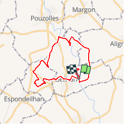
Trail Other activity of 14.7 km to be discovered at Occitania, Hérault, Abeilhan. This trail is proposed by Daron34.

Description

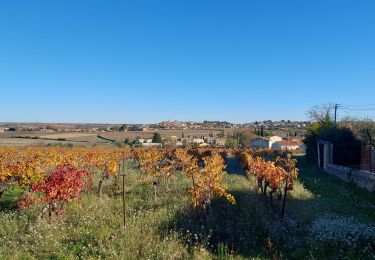
Au départ de la cave coopérative, partez pour une longue virée sur les coteaux viticoles de la Thongue et autour des nombreux "pechs" (petites collines) à la découverte d'un territoire façonné par l'homme pour la vigne.

Elevation profile

Points of interest

Point of interest Abeilhan - Etape 1 - Photo
Daron34
ABEILHAN 
Point of interest Abeilhan - Etape 2 - Photo
Daron34
ABEILHAN 
Point of interest Alignan-du-Vent - Etape 3 - Photo
Daron34
ALIGNAN-DU-VENT 
Point of interest Abeilhan - Etape 4 - Photo
Daron34
ABEILHAN 
Point of interest Pouzolles - Etape 5 - Photo
Daron34
POUZOLLES 
Point of interest Coulobres - Etape 6 - Photo
Daron34
COULOBRES 
Point of interest Coulobres - Etape 7 - Photo
Daron34
COULOBRES 
Point of interest Coulobres - Etape 8 - Photo
Daron34
COULOBRES 
Point of interest Abeilhan - Etape 9 - Photo
Daron34
ABEILHAN 

Positioning

Country:
France
Region :
Occitania
Department/Province :
Hérault
Municipality :
Abeilhan
Location:
Unknown
Start:(UTM)
524541 ; 4810933 (31T) N.

Trails nearby

Trail Mountain bike Servian - Les croix de Servian - Photo
Mountain bike
tracegps

Mountain bike

Difficult
(4)
Servian, Occitania, Hérault, France
27 km | 30 km-effort
3h 15min
Yes
Trail Walking Abeilhan - Abeilhan coteaux de la Thongue  - Photo
Walking
Raymond DAVID

Walking

Easy
Abeilhan, Occitania, Hérault, France
30 km | 35 km-effort
4h 30min
No
Trail On foot Servian - Valros
On foot
jpschmitz

On foot

Easy
Servian, Occitania, Hérault, France
13.5 km | 15.5 km-effort
3h 31min
Yes
Trail Mountain bike Servian - Servian 2023 - Photo
Mountain bike
pates_au_chaud

Mountain bike

Easy
Servian, Occitania, Hérault, France
28 km | 32 km-effort
2h 9min
Yes
Trail Walking Alignan-du-Vent - Allignan du Vent Travers courte - Photo
Walking
jeanne2209

Walking

Medium
Alignan-du-Vent, Occitania, Hérault, France
5.8 km | 6.8 km-effort
1h 33min
Yes
Trail sport Alignan-du-Vent - 2022-07-20_11h21m56_Cirkwi-OENORANDO®_DES_BALCONS_D_ALIGNAN_DU_VENT - Photo
sport
jeanne2209

sport

Very easy
Alignan-du-Vent, Occitania, Hérault, France
12.7 km | 14.9 km-effort
Unknown
Yes
Trail Walking Servian - hyper u Servian Abeilhan - Photo
Walking
Daron34

Walking

Very easy
Servian, Occitania, Hérault, France
12.6 km | 14.3 km-effort
3h 23min
Yes
Trail On foot Coulobres - La Thongue et ses côteaux - Photo
On foot
GUIDE+

On foot

Easy
Coulobres, Occitania, Hérault, France
4.5 km | 5.2 km-effort
1h 11min
No
Trail Running Servian - Servian - Photo
Running
PiloudeBamako

Running

Difficult
Servian, Occitania, Hérault, France
10.5 km | 12 km-effort
1h 8min
Yes


Close
My subscriptions