![](/images/other/stat-length.png)
![Trail Cycle Balen - Balen Koersel Kamp 61.5 km - Photo](https://media.geolcdn.com/t/1900/400/ext.pjpeg?maxdim=2&url=https%3A%2F%2Fstatic1.geolcdn.com%2Fsiteimages%2Fupload%2Ffiles%2F1524743154velo.jpg)
Balen Koersel Kamp 61.5 km
marjence
User
![Length](/images/other/stat-length.png)
Length
59 km
![Max alt](https://static1.geolcdn.com/siteimages/upload/files/1508320355ic_sort_altitude_max_24dp.png)
Max alt
73 m
![Uphill gradient](https://static1.geolcdn.com/siteimages/upload/files/1508320355ic_sort_den_pos_24dp.png)
Uphill gradient
412 m
![Km-Effort](/images/other/stat-length.png)
Km-Effort
65 km
![Min alt](https://static1.geolcdn.com/siteimages/upload/files/1508320355ic_sort_altitude_min_24dp.png)
Min alt
23 m
![Downhill gradient](https://static1.geolcdn.com/siteimages/upload/files/1508320355ic_sort_den_neg_24dp.png)
Downhill gradient
411 m
![Boucle](https://static1.geolcdn.com/siteimages/upload/files/16400158638029165_repeat_loop_refresh_sync_direction_icon.png)
Boucle
Yes
Creation date :
2018-06-26 15:39:19.245
Updated on :
2018-06-26 15:39:19.245
![Cycle](https://static1.geolcdn.com/sitytour/trail-icons/200.png)
3h42
Difficulty : Easy
![Scan this QR Code to open this trail in the SityTrail application](https://capi.geolives.com/qq0zvz2zws4bq2lad0pu/sitytour/trails/980646/qr.png?size=200)
FREE GPS app for hiking
About
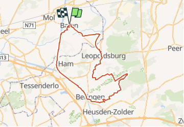
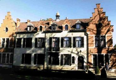
Trail Cycle of 59 km to be discovered at Flanders, Antwerp, Balen. This trail is proposed by marjence.
Description
Langs kanaal naar Beringen
33 38 338 339 503 345 343 310 518 plan tot naar 341 342 554 555 zie plan Drakar naar 275 30 24 dan zie plan.
op 15 km Tav De Sleepvaart
op 31 km Tav De Uitkijktoren
op 49 km Cafe Drakar Kom.
Points of interest
Positioning
Country:
Belgium
Region :
Flanders
Department/Province :
Antwerp
Municipality :
Balen
Location:
Balen
Start:(Dec)
Start:(UTM)
651776 ; 5671207 (31U) N.
Comments
Trails nearby
![Trail On foot Mol - Merenpad 7km - Photo](https://media.geolcdn.com/t/375/260/ext.jpg?maxdim=2&url=https%3A%2F%2Fmedia.geolcdn.com%2Ff%2F4f059d46-9351-4bfb-b85c-d0034645b3fe.jpeg)
![On foot On foot](https://static1.geolcdn.com/sitytour/trail-icons/100.png)
![Trail On foot Mol - Vossenpad - Photo](https://media.geolcdn.com/t/375/260/ext.jpg?maxdim=2&url=https%3A%2F%2Fmedia.geolcdn.com%2Ff%2F75a65dc1-916f-4553-b299-c45ffacf0596.jpeg)
![On foot On foot](https://static1.geolcdn.com/sitytour/trail-icons/100.png)
![Trail On foot Mol - Galbergenpad - Photo](https://media.geolcdn.com/t/375/260/ext.jpg?maxdim=2&url=https%3A%2F%2Fmedia.geolcdn.com%2Ff%2Fac6c45ad-0a3f-46f0-8730-3bf99148b3e6.jpeg)
![On foot On foot](https://static1.geolcdn.com/sitytour/trail-icons/100.png)
![Trail On foot Mol - Netepad - Photo](https://media.geolcdn.com/t/375/260/ext.jpg?maxdim=2&url=https%3A%2F%2Fmedia.geolcdn.com%2Ff%2Fb8d824ab-b7ec-46ac-901d-e1a19a60eee0.jpeg)
![On foot On foot](https://static1.geolcdn.com/sitytour/trail-icons/100.png)
![Trail On foot Mol - Merenpad - Photo](https://media.geolcdn.com/t/375/260/ext.jpg?maxdim=2&url=https%3A%2F%2Fmedia.geolcdn.com%2Ff%2F03f8c97e-ed17-4356-a72b-3f3c82846f0d.jpeg)
![On foot On foot](https://static1.geolcdn.com/sitytour/trail-icons/100.png)
![Trail On foot Mol - Molderbroek - Photo](https://media.geolcdn.com/t/375/260/ext.jpg?maxdim=2&url=https%3A%2F%2Fmedia.geolcdn.com%2Ff%2F32283c9e-d5f6-4605-bd23-011fb998e17e.jpeg)
![On foot On foot](https://static1.geolcdn.com/sitytour/trail-icons/100.png)
![Trail On foot Balen - Keiheuvelwandeling - Photo](https://media.geolcdn.com/t/375/260/ext.jpg?maxdim=2&url=https%3A%2F%2Fmedia.geolcdn.com%2Ff%2Fea987881-3e8c-4e28-b291-d48e23e3d378.jpeg)
![On foot On foot](https://static1.geolcdn.com/sitytour/trail-icons/100.png)
Keiheuvelwandeling
On foot
Easy
Balen,
Flanders,
Antwerp,
Belgium
![](/images/other/stat-length.png)
11.2 km | 12.1 km-effort
2h 44min
![](https://static1.geolcdn.com/siteimages/upload/files/16400158638029165_repeat_loop_refresh_sync_direction_icon.png)
Yes
![Trail On foot Mol - Buitengoor groene vlam - Photo](https://media.geolcdn.com/t/375/260/ext.jpg?maxdim=2&url=https%3A%2F%2Fmedia.geolcdn.com%2Ff%2F4f059d46-9351-4bfb-b85c-d0034645b3fe.jpeg)
![On foot On foot](https://static1.geolcdn.com/sitytour/trail-icons/100.png)
Buitengoor groene vlam
On foot
Easy
Mol,
Flanders,
Antwerp,
Belgium
![](/images/other/stat-length.png)
3.1 km | 3.3 km-effort
45min
![](https://static1.geolcdn.com/siteimages/upload/files/16400158638029165_repeat_loop_refresh_sync_direction_icon.png)
Yes
![Trail On foot Mol - Drevenpad - Photo](https://media.geolcdn.com/t/375/260/ext.jpg?maxdim=2&url=https%3A%2F%2Fmedia.geolcdn.com%2Ff%2F1d762665-4b2e-4322-818b-3136f134e461.jpeg)
![On foot On foot](https://static1.geolcdn.com/sitytour/trail-icons/100.png)