![](/images/other/stat-length.png)
![Trail Walking Cuges-les-Pins - Le Mont Cruvelier - Photo](https://media.geolcdn.com/t/1900/400/ext.pjpeg?maxdim=2&url=https%3A%2F%2Fstatic1.geolcdn.com%2Fsiteimages%2Fupload%2Ffiles%2F1553511878bg_sport_marche.png)
Le Mont Cruvelier
pourrier
User
![Length](/images/other/stat-length.png)
Length
16.1 km
![Max alt](https://static1.geolcdn.com/siteimages/upload/files/1508320355ic_sort_altitude_max_24dp.png)
Max alt
659 m
![Uphill gradient](https://static1.geolcdn.com/siteimages/upload/files/1508320355ic_sort_den_pos_24dp.png)
Uphill gradient
589 m
![Km-Effort](/images/other/stat-length.png)
Km-Effort
24 km
![Min alt](https://static1.geolcdn.com/siteimages/upload/files/1508320355ic_sort_altitude_min_24dp.png)
Min alt
222 m
![Downhill gradient](https://static1.geolcdn.com/siteimages/upload/files/1508320355ic_sort_den_neg_24dp.png)
Downhill gradient
587 m
![Boucle](https://static1.geolcdn.com/siteimages/upload/files/16400158638029165_repeat_loop_refresh_sync_direction_icon.png)
Boucle
Yes
Creation date :
2018-10-09 15:43:46.622
Updated on :
2018-10-09 15:43:46.695
![Walking](https://static1.geolcdn.com/sitytour/trail-icons/101.png)
5h46
Difficulty : Medium
![Scan this QR Code to open this trail in the SityTrail application](https://capi.geolives.com/qq0zvz2zws4bq2lad0pu/sitytour/trails/98063/qr.png?size=200)
FREE GPS app for hiking
About
Trail Walking of 16.1 km to be discovered at Provence-Alpes-Côte d'Azur, Bouches-du-Rhône, Cuges-les-Pins. This trail is proposed by pourrier.
Description
Point de vue magnifique sur le Pic de Bertagne, Marseille et la Côte Bleue et le Pays d'Aubagne.
Très fort Mistral qui nous a fait écourter la promenade.
Positioning
Country:
France
Region :
Provence-Alpes-Côte d'Azur
Department/Province :
Bouches-du-Rhône
Municipality :
Cuges-les-Pins
Location:
Unknown
Start:(Dec)
Start:(UTM)
716660 ; 4793841 (31T) N.
Comments
Trails nearby
![Trail Walking Roquefort-la-Bédoule - Grand Caunet, le Montounier - Photo](https://media.geolcdn.com/t/375/260/6da96041-d8db-45b9-9840-88b8ee06ae33.jpg&format=jpg&maxdim=2)
![Walking Walking](https://static1.geolcdn.com/sitytour/trail-icons/101.png)
Grand Caunet, le Montounier
Walking
Medium
(1)
Roquefort-la-Bédoule,
Provence-Alpes-Côte d'Azur,
Bouches-du-Rhône,
France
![](/images/other/stat-length.png)
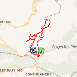
16.5 km | 24 km-effort
6h 0min
![](https://static1.geolcdn.com/siteimages/upload/files/16400158638029165_repeat_loop_refresh_sync_direction_icon.png)
Yes
![Trail Walking Ceyreste - Autour du Montounier 2eme version - Photo](https://media.geolcdn.com/t/375/260/aea50e59-26c4-4704-b6d5-ac40178213cc.jpg&format=jpg&maxdim=2)
![Walking Walking](https://static1.geolcdn.com/sitytour/trail-icons/101.png)
Autour du Montounier 2eme version
Walking
Medium
(1)
Ceyreste,
Provence-Alpes-Côte d'Azur,
Bouches-du-Rhône,
France
![](/images/other/stat-length.png)
15.7 km | 24 km-effort
6h 0min
![](https://static1.geolcdn.com/siteimages/upload/files/16400158638029165_repeat_loop_refresh_sync_direction_icon.png)
Yes
![Trail Walking Roquefort-la-Bédoule - SityTrail - Grand Caunet, Cabanons, Vigie , Grotte Raymond, Ruines roquefort, Chapelle St andré - Photo](https://media.geolcdn.com/t/375/260/f9c0beb6-6483-4b14-ba76-b33fa5e2208b.jpg&format=jpg&maxdim=2)
![Walking Walking](https://static1.geolcdn.com/sitytour/trail-icons/101.png)
SityTrail - Grand Caunet, Cabanons, Vigie , Grotte Raymond, Ruines roquefort,...
Walking
Easy
(1)
Roquefort-la-Bédoule,
Provence-Alpes-Côte d'Azur,
Bouches-du-Rhône,
France
![](/images/other/stat-length.png)
14.2 km | 19.9 km-effort
6h 0min
![](https://static1.geolcdn.com/siteimages/upload/files/16400158638029165_repeat_loop_refresh_sync_direction_icon.png)
Yes
![Trail Walking Le Castellet - SityTrail - 2361987 - begude - Photo](https://media.geolcdn.com/t/375/260/dbe90af6-979b-4145-807f-db327fb40379.jpg&format=jpg&maxdim=2)
![Walking Walking](https://static1.geolcdn.com/sitytour/trail-icons/101.png)
SityTrail - 2361987 - begude
Walking
Medium
(1)
Le Castellet,
Provence-Alpes-Côte d'Azur,
Var,
France
![](/images/other/stat-length.png)
11.5 km | 15.1 km-effort
4h 0min
![](https://static1.geolcdn.com/siteimages/upload/files/16400158638029165_repeat_loop_refresh_sync_direction_icon.png)
Yes
![Trail Walking Gémenos - St Pons Le Fauge Glacière - Photo](https://media.geolcdn.com/t/375/260/ext.jpg?maxdim=2&url=https%3A%2F%2Fservices.sitytrail.com%2FGeolivesWS%2FDownloadMedia.ashx%3FTrailID%3D954893%26Media%3Dfix__20180430171638.jpg)
![Walking Walking](https://static1.geolcdn.com/sitytour/trail-icons/101.png)
St Pons Le Fauge Glacière
Walking
Difficult
(1)
Gémenos,
Provence-Alpes-Côte d'Azur,
Bouches-du-Rhône,
France
![](/images/other/stat-length.png)
11.7 km | 18.6 km-effort
3h 56min
![](https://static1.geolcdn.com/siteimages/upload/files/16400158638029165_repeat_loop_refresh_sync_direction_icon.png)
Yes
![Trail Walking Roquefort-la-Bédoule - la petite sainte baume - Photo](https://media.geolcdn.com/t/375/260/24f466c4-80fb-4267-898b-b6a75ae27664.jpg&format=jpg&maxdim=2)
![Walking Walking](https://static1.geolcdn.com/sitytour/trail-icons/101.png)
la petite sainte baume
Walking
Easy
(1)
Roquefort-la-Bédoule,
Provence-Alpes-Côte d'Azur,
Bouches-du-Rhône,
France
![](/images/other/stat-length.png)
13.9 km | 19.3 km-effort
5h 37min
![](https://static1.geolcdn.com/siteimages/upload/files/16400158638029165_repeat_loop_refresh_sync_direction_icon.png)
Yes
![Trail Walking Gémenos - autour de Saint pons - Photo](https://media.geolcdn.com/t/375/260/ext.jpg?maxdim=2&url=https%3A%2F%2Fservices.sitytrail.com%2FGeolivesWS%2FDownloadMedia.ashx%3FTrailID%3D723506%26Media%3Dfix__20170330154755.jpg)
![Walking Walking](https://static1.geolcdn.com/sitytour/trail-icons/101.png)
autour de Saint pons
Walking
Easy
(1)
Gémenos,
Provence-Alpes-Côte d'Azur,
Bouches-du-Rhône,
France
![](/images/other/stat-length.png)
11.6 km | 16.1 km-effort
3h 46min
![](https://static1.geolcdn.com/siteimages/upload/files/16400158638029165_repeat_loop_refresh_sync_direction_icon.png)
Yes
![Trail Mountain bike Gémenos - Gémenos - La Grande Baume - Photo](https://media.geolcdn.com/t/375/260/ext.jpg?maxdim=2&url=https%3A%2F%2Fservices.sitytrail.com%2FGeolivesWS%2FDownloadMedia.ashx%3FTrailID%3D104196%26Media%3D7328_1.jpg)
![Mountain bike Mountain bike](https://static1.geolcdn.com/sitytour/trail-icons/202.png)
Gémenos - La Grande Baume
Mountain bike
Difficult
(1)
Gémenos,
Provence-Alpes-Côte d'Azur,
Bouches-du-Rhône,
France
![](/images/other/stat-length.png)
18.4 km | 29 km-effort
3h 30min
![](https://static1.geolcdn.com/siteimages/upload/files/16400158638029165_repeat_loop_refresh_sync_direction_icon.png)
Yes
![Trail Walking Roquefort-la-Bédoule - Barres de Font Blanche - Photo](https://media.geolcdn.com/t/375/260/ext.jpg?maxdim=2&url=https%3A%2F%2Fservices.sitytrail.com%2FGeolivesWS%2FDownloadMedia.ashx%3FTrailID%3D103784%26Media%3D6554_1.jpg)
![Walking Walking](https://static1.geolcdn.com/sitytour/trail-icons/101.png)
Barres de Font Blanche
Walking
Medium
(1)
Roquefort-la-Bédoule,
Provence-Alpes-Côte d'Azur,
Bouches-du-Rhône,
France
![](/images/other/stat-length.png)
10.3 km | 14.4 km-effort
2h 19min
![](https://static1.geolcdn.com/siteimages/upload/files/16400158638029165_repeat_loop_refresh_sync_direction_icon.png)
Yes