![](/images/other/stat-length.png)
![Trail Walking Moigny-sur-École - Moigny sur Ecole,Le Pressoir, Le Cyclop - Photo](https://media.geolcdn.com/t/1900/400/ext.pjpeg?maxdim=2&url=https%3A%2F%2Fstatic1.geolcdn.com%2Fsiteimages%2Fupload%2Ffiles%2F1553511878bg_sport_marche.png)
Moigny sur Ecole,Le Pressoir, Le Cyclop
Surot
User
![Length](/images/other/stat-length.png)
Length
19.8 km
![Max alt](https://static1.geolcdn.com/siteimages/upload/files/1508320355ic_sort_altitude_max_24dp.png)
Max alt
144 m
![Uphill gradient](https://static1.geolcdn.com/siteimages/upload/files/1508320355ic_sort_den_pos_24dp.png)
Uphill gradient
322 m
![Km-Effort](/images/other/stat-length.png)
Km-Effort
24 km
![Min alt](https://static1.geolcdn.com/siteimages/upload/files/1508320355ic_sort_altitude_min_24dp.png)
Min alt
65 m
![Downhill gradient](https://static1.geolcdn.com/siteimages/upload/files/1508320355ic_sort_den_neg_24dp.png)
Downhill gradient
322 m
![Boucle](https://static1.geolcdn.com/siteimages/upload/files/16400158638029165_repeat_loop_refresh_sync_direction_icon.png)
Boucle
Yes
Creation date :
2018-06-26 15:37:42.987
Updated on :
2018-06-26 15:37:42.987
![Walking](https://static1.geolcdn.com/sitytour/trail-icons/101.png)
5h15
Difficulty : Medium
![Scan this QR Code to open this trail in the SityTrail application](https://capi.geolives.com/qq0zvz2zws4bq2lad0pu/sitytour/trails/980428/qr.png?size=200)
FREE GPS app for hiking
About
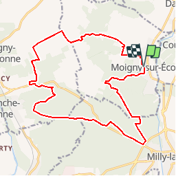
Trail Walking of 19.8 km to be discovered at Ile-de-France, Essonne, Moigny-sur-École. This trail is proposed by Surot.
Description
Parcours diversifié entre un peu de champ et beaucoup de bois et forêts, cheminement facile, pique-nique aisé près du rocher de Chatillon, quelques montées et descentes modérées, intéret du polissoir en passant et cu Cyclop.
Positioning
Country:
France
Region :
Ile-de-France
Department/Province :
Essonne
Municipality :
Moigny-sur-École
Location:
Unknown
Start:(Dec)
Start:(UTM)
459688 ; 5364521 (31U) N.
Comments
Trails nearby
![Trail On foot Saint-Germain-sur-École - Boucle Soisy Sur Ecole - Photo](https://media.geolcdn.com/t/375/260/191519f5-31af-4b92-abf3-6dc57900b32f.jpg&format=jpg&maxdim=2)
![On foot On foot](https://static1.geolcdn.com/sitytour/trail-icons/100.png)
Boucle Soisy Sur Ecole
On foot
Medium
(1)
Saint-Germain-sur-École,
Ile-de-France,
Seine-et-Marne,
France
![](/images/other/stat-length.png)
21 km | 25 km-effort
5h 39min
![](https://static1.geolcdn.com/siteimages/upload/files/16400158638029165_repeat_loop_refresh_sync_direction_icon.png)
Yes
![Trail Walking Milly-la-Forêt - Du parking de la Boulignère aux 100 marches via la ferme des Coquibus - Photo](https://media.geolcdn.com/t/375/260/2d4021ff-70a8-48ff-ad65-d6df60ccba59.jpg&format=jpg&maxdim=2)
![Walking Walking](https://static1.geolcdn.com/sitytour/trail-icons/101.png)
Du parking de la Boulignère aux 100 marches via la ferme des Coquibus
Walking
Difficult
(1)
Milly-la-Forêt,
Ile-de-France,
Essonne,
France
![](/images/other/stat-length.png)
18.3 km | 22 km-effort
5h 0min
![](https://static1.geolcdn.com/siteimages/upload/files/16400158638029165_repeat_loop_refresh_sync_direction_icon.png)
Yes
![Trail On foot Milly-la-Forêt - Boucle 16 km Coquibus - Platières - Photo](https://media.geolcdn.com/t/375/260/6a2a1ae6-ffd2-44a3-8670-01d58b5995c6.jpg&format=jpg&maxdim=2)
![On foot On foot](https://static1.geolcdn.com/sitytour/trail-icons/100.png)
Boucle 16 km Coquibus - Platières
On foot
Easy
Milly-la-Forêt,
Ile-de-France,
Essonne,
France
![](/images/other/stat-length.png)
16.2 km | 19.4 km-effort
4h 24min
![](https://static1.geolcdn.com/siteimages/upload/files/16400158638029165_repeat_loop_refresh_sync_direction_icon.png)
Yes
![Trail Walking Milly-la-Forêt - Boucle 29 km Milly La Forêt - Le Vaudoué - Tousson - Photo](https://media.geolcdn.com/t/375/260/3058c3db-123e-4ec5-b295-1e7b4c8ce449.jpg&format=jpg&maxdim=2)
![Walking Walking](https://static1.geolcdn.com/sitytour/trail-icons/101.png)
Boucle 29 km Milly La Forêt - Le Vaudoué - Tousson
Walking
Difficult
Milly-la-Forêt,
Ile-de-France,
Essonne,
France
![](/images/other/stat-length.png)
29 km | 33 km-effort
5h 56min
![](https://static1.geolcdn.com/siteimages/upload/files/16400158638029165_repeat_loop_refresh_sync_direction_icon.png)
Yes
![Trail Walking Saint-Germain-sur-École - Boucle soisy version definitif - Photo](https://media.geolcdn.com/t/375/260/393daa89-85e9-457d-aec1-026a61438d59.jpg&format=jpg&maxdim=2)
![Walking Walking](https://static1.geolcdn.com/sitytour/trail-icons/101.png)
Boucle soisy version definitif
Walking
Easy
Saint-Germain-sur-École,
Ile-de-France,
Seine-et-Marne,
France
![](/images/other/stat-length.png)
22 km | 26 km-effort
4h 53min
![](https://static1.geolcdn.com/siteimages/upload/files/16400158638029165_repeat_loop_refresh_sync_direction_icon.png)
Yes
![Trail Walking Noisy-sur-École - le-circuit-des-25-bosses-fontainebleau - Photo](https://media.geolcdn.com/t/375/260/ext.jpg?maxdim=2&url=https%3A%2F%2Fstatic1.geolcdn.com%2Fsiteimages%2Fupload%2Ffiles%2F1553511878bg_sport_marche.png)
![Walking Walking](https://static1.geolcdn.com/sitytour/trail-icons/101.png)
le-circuit-des-25-bosses-fontainebleau
Walking
Very difficult
(1)
Noisy-sur-École,
Ile-de-France,
Seine-et-Marne,
France
![](/images/other/stat-length.png)
17.6 km | 23 km-effort
5h 17min
![](https://static1.geolcdn.com/siteimages/upload/files/16400158638029165_repeat_loop_refresh_sync_direction_icon.png)
Yes
![Trail Walking Milly-la-Forêt - Boucle Milly - Noisy - Le Vaudoué - Photo](https://media.geolcdn.com/t/375/260/e9bfccdb-7efb-4974-aaa0-3d18cc8b7546.jpg&format=jpg&maxdim=2)
![Walking Walking](https://static1.geolcdn.com/sitytour/trail-icons/101.png)
Boucle Milly - Noisy - Le Vaudoué
Walking
Medium
Milly-la-Forêt,
Ile-de-France,
Essonne,
France
![](/images/other/stat-length.png)
25 km | 28 km-effort
5h 28min
![](https://static1.geolcdn.com/siteimages/upload/files/16400158638029165_repeat_loop_refresh_sync_direction_icon.png)
No
![Trail Walking Noisy-sur-École - Le circuit des 25 bosses - Photo](https://media.geolcdn.com/t/375/260/75e2e42e-b9fb-4b6e-9c9f-0c0495c8b5aa.jpg&format=jpg&maxdim=2)
![Walking Walking](https://static1.geolcdn.com/sitytour/trail-icons/101.png)
Le circuit des 25 bosses
Walking
Very difficult
Noisy-sur-École,
Ile-de-France,
Seine-et-Marne,
France
![](/images/other/stat-length.png)
17.5 km | 23 km-effort
5h 31min
![](https://static1.geolcdn.com/siteimages/upload/files/16400158638029165_repeat_loop_refresh_sync_direction_icon.png)
Yes
![Trail Walking Saint-Germain-sur-École - Autour de Soisy sur Ecole - Boucle 30 km - Photo](https://media.geolcdn.com/t/375/260/42a45b0a-7dbc-4142-a18c-2c21a7c16f7f.jpg&format=jpg&maxdim=2)
![Walking Walking](https://static1.geolcdn.com/sitytour/trail-icons/101.png)
Autour de Soisy sur Ecole - Boucle 30 km
Walking
Medium
Saint-Germain-sur-École,
Ile-de-France,
Seine-et-Marne,
France
![](/images/other/stat-length.png)
30 km | 36 km-effort
6h 3min
![](https://static1.geolcdn.com/siteimages/upload/files/16400158638029165_repeat_loop_refresh_sync_direction_icon.png)
Yes