


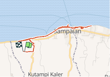
Balade vers le port de Nusa Penida

lhomme.ph
User GUIDE

Length
7.2 km

Max alt
74 m

Uphill gradient
107 m
Km-Effort
8.6 km

Min alt
0 m

Downhill gradient
107 m
Boucle
Yes
Creation date :
2018-06-27 12:08:06.776
Updated on :
2018-06-27 12:08:06.776
3h04
Difficulty : Unknown

FREE GPS app for hiking
 SityTrail
IGN / Geographical institutes
SityTrail World
The world is yours!
About
Trail Other activity of 7.2 km to be discovered at Bali. This trail is proposed by lhomme.ph.
Positioning
Country:
Indonesia
Region :
Bali
Department/Province :
Toyapakeh
Municipality :
Toyapakeh
Location:
Unknown
Start:(Dec)
Start:(UTM)
339404 ; 9040298 (50L) S.
Comments
Trails nearby