Trail Walking Beychac-et-Caillau - Caillau1 - Photo
© OpenStreetMap contributors
Length
Length
7.9 km
Max alt
Max alt
84 m
Uphill gradient
Uphill gradient
90 m
Km-Effort
Km-Effort  
9.1 km
Min alt
Min alt
40 m
Downhill gradient
Downhill gradient
91 m
Boucle
Boucle
Yes
Creation date :
2018-06-26 15:08:29.875
Updated on :
2018-06-26 15:08:29.875

(0 Reviews)

Walking
Walking
3h28
Difficulty : Easy

Scan this QR Code to open this trail in the SityTrail application

FREE GPS app for hiking

Logo SityTrail SityTrail

IGN / Geographical institutes

Download SityTrail from the App Store Download SityTrail from Google Play

Logo SityTrail SityTrail World

The world is yours!

Download SityTrail from the App Store Download SityTrail from Google Play Download SityTrail on Huawei AppGallery

About

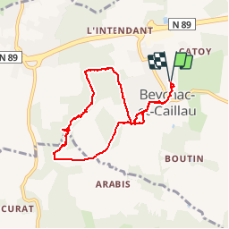
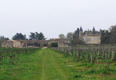
Trail Walking of 7.9 km to be discovered at New Aquitaine, Gironde, Beychac-et-Caillau. This trail is proposed by frandominic.

Description

1/2 boucle du circuit de Caillau

Elevation profile

Positioning

Country:
France
Region :
New Aquitaine
Department/Province :
Gironde
Municipality :
Beychac-et-Caillau
Location:
Unknown
Start:(UTM)
707684 ; 4972128 (30T) N.

Trails nearby

Trail Walking Saint-Germain-du-Puch - Saint-germain-du-puch - Photo
Walking
herve747

Walking

Easy
Saint-Germain-du-Puch, New Aquitaine, Gironde, France
9 km | 10.2 km-effort
2h 12min
Yes
Trail Walking Saint-Loubès - 2023-11-13-St loubès - Photo
Walking
turbo33

Walking

Medium
Saint-Loubès, New Aquitaine, Gironde, France
9.6 km | 10.5 km-effort
2h 13min
Yes
Trail Walking Saint-Germain-du-Puch - Beaupied - Photo
Walking
frandominic

Walking

Difficult
Saint-Germain-du-Puch, New Aquitaine, Gironde, France
15.7 km | 17.8 km-effort
4h 3min
Yes
Trail Walking Beychac-et-Caillau - Caillau - Photo
Walking
frandominic

Walking

Difficult
Beychac-et-Caillau, New Aquitaine, Gironde, France
16.7 km | 19.7 km-effort
4h 18min
Yes
Trail Walking Saint-Germain-du-Puch - autour de Beaupied - Photo
Walking
plavengut

Walking

Easy
Saint-Germain-du-Puch, New Aquitaine, Gironde, France
11 km | 12.7 km-effort
3h 29min
Yes
Trail Walking Montussan - montussan - Photo
Walking
turbo33

Walking

Medium
Montussan, New Aquitaine, Gironde, France
10.3 km | 12.4 km-effort
2h 17min
Yes
Trail Walking Montussan - Montussan - Photo
Walking
turbo33

Walking

Medium
Montussan, New Aquitaine, Gironde, France
11.3 km | 13.8 km-effort
2h 25min
Yes
Trail Walking Vayres - Vayres Matin - Photo
Walking
Lessire

Walking

Easy
Vayres, New Aquitaine, Gironde, France
4.9 km | 5.5 km-effort
1h 14min
No
Trail Walking Vayres - Vayres am - Photo
Walking
Lessire

Walking

Medium
(1)
Vayres, New Aquitaine, Gironde, France
9.1 km | 9.6 km-effort
2h 11min
Yes


Close
My subscriptions