![](/images/other/stat-length.png)
![Trail Walking Sagres - Plage du Telheiro - Photo](https://media.geolcdn.com/t/1900/400/ext.pjpeg?maxdim=2&url=https%3A%2F%2Fstatic1.geolcdn.com%2Fsiteimages%2Fupload%2Ffiles%2F1553511878bg_sport_marche.png)
Plage du Telheiro
rigol05
User
![Length](/images/other/stat-length.png)
Length
15.2 km
![Max alt](https://static1.geolcdn.com/siteimages/upload/files/1508320355ic_sort_altitude_max_24dp.png)
Max alt
98 m
![Uphill gradient](https://static1.geolcdn.com/siteimages/upload/files/1508320355ic_sort_den_pos_24dp.png)
Uphill gradient
205 m
![Km-Effort](/images/other/stat-length.png)
Km-Effort
17.9 km
![Min alt](https://static1.geolcdn.com/siteimages/upload/files/1508320355ic_sort_altitude_min_24dp.png)
Min alt
24 m
![Downhill gradient](https://static1.geolcdn.com/siteimages/upload/files/1508320355ic_sort_den_neg_24dp.png)
Downhill gradient
209 m
![Boucle](https://static1.geolcdn.com/siteimages/upload/files/16400158638029165_repeat_loop_refresh_sync_direction_icon.png)
Boucle
Yes
Creation date :
2018-06-26 14:53:48.148
Updated on :
2018-06-26 14:53:48.148
![Walking](https://static1.geolcdn.com/sitytour/trail-icons/101.png)
3h56
Difficulty : Unknown
![Scan this QR Code to open this trail in the SityTrail application](https://capi.geolives.com/qq0zvz2zws4bq2lad0pu/sitytour/trails/973752/qr.png?size=200)
FREE GPS app for hiking
About
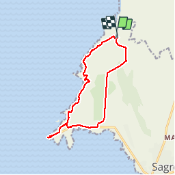
Trail Walking of 15.2 km to be discovered at Algarve, Faro, Sagres. This trail is proposed by rigol05.
Description
sortie du 14-05
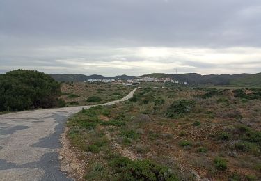
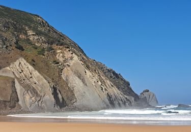
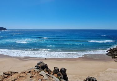
Départ de Ponta Ruiva suivre la piste sur 6km depuis Vila do Bispo. Au retour l'itinéraire manque d'intérêt (trop de route)De Ponta Ruiva au Cabo S.Vicente le sentier suivant la côte est magnifique. Le départ sud à partir du cap St. Vincent est plus accessible donc préférable.
Positioning
Country:
Portugal
Region :
Algarve
Department/Province :
Faro
Municipality :
Sagres
Location:
Unknown
Start:(Dec)
Start:(UTM)
503306 ; 4101858 (29S) N.
Comments
Trails nearby
![Trail Walking - Sagres cap St VINCENT Carrapateria - Photo](https://media.geolcdn.com/t/375/260/5fbc8ff6-bcde-4b54-961a-80919cd27a85.jpg&format=jpg&maxdim=2)
![Walking Walking](https://static1.geolcdn.com/sitytour/trail-icons/101.png)
Sagres cap St VINCENT Carrapateria
Walking
Medium
,
Algarve,
Faro,
Portugal
![](/images/other/stat-length.png)
40 km | 50 km-effort
12h 35min
![](https://static1.geolcdn.com/siteimages/upload/files/16400158638029165_repeat_loop_refresh_sync_direction_icon.png)
No
![Trail Walking Vila do Bispo e Raposeira - ALGARVE - En route pour le Ponte de Aspa - Photo](https://media.geolcdn.com/t/375/260/d7881009-8f96-4881-96b4-bb90c83d4140.jpg&format=jpg&maxdim=2)
![Walking Walking](https://static1.geolcdn.com/sitytour/trail-icons/101.png)
ALGARVE - En route pour le Ponte de Aspa
Walking
Medium
Vila do Bispo e Raposeira,
Algarve,
Faro,
Portugal
![](/images/other/stat-length.png)
16 km | 20 km-effort
4h 56min
![](https://static1.geolcdn.com/siteimages/upload/files/16400158638029165_repeat_loop_refresh_sync_direction_icon.png)
Yes
![Trail Walking Sagres - ALGARVE - Grande boucle près du Cabo de São Vicente - Photo](https://media.geolcdn.com/t/375/260/5ce2cd61-df05-4c2d-8c5b-68f54945868c.jpg&format=jpg&maxdim=2)
![Walking Walking](https://static1.geolcdn.com/sitytour/trail-icons/101.png)
ALGARVE - Grande boucle près du Cabo de São Vicente
Walking
Medium
Sagres,
Algarve,
Faro,
Portugal
![](/images/other/stat-length.png)
15.5 km | 18.7 km-effort
4h 41min
![](https://static1.geolcdn.com/siteimages/upload/files/16400158638029165_repeat_loop_refresh_sync_direction_icon.png)
Yes
![Trail Walking Vila do Bispo e Raposeira - Boucle de Ponte de Aspa - Photo](https://media.geolcdn.com/t/375/260/ext.jpg?maxdim=2&url=https%3A%2F%2Fstatic1.geolcdn.com%2Fsiteimages%2Fupload%2Ffiles%2F1553511878bg_sport_marche.png)
![Walking Walking](https://static1.geolcdn.com/sitytour/trail-icons/101.png)
Boucle de Ponte de Aspa
Walking
Medium
Vila do Bispo e Raposeira,
Algarve,
Faro,
Portugal
![](/images/other/stat-length.png)
15.9 km | 21 km-effort
3h 48min
![](https://static1.geolcdn.com/siteimages/upload/files/16400158638029165_repeat_loop_refresh_sync_direction_icon.png)
Yes
![Trail Walking Sagres - Sages - Cabo de São Vincent 9-10-2019 - Photo](https://media.geolcdn.com/t/375/260/ext.jpg?maxdim=2&url=https%3A%2F%2Fstatic1.geolcdn.com%2Fsiteimages%2Fupload%2Ffiles%2F1553511878bg_sport_marche.png)
![Walking Walking](https://static1.geolcdn.com/sitytour/trail-icons/101.png)
Sages - Cabo de São Vincent 9-10-2019
Walking
Easy
Sagres,
Algarve,
Faro,
Portugal
![](/images/other/stat-length.png)
9.5 km | 12 km-effort
2h 44min
![](https://static1.geolcdn.com/siteimages/upload/files/16400158638029165_repeat_loop_refresh_sync_direction_icon.png)
Yes
![Trail Walking Vila do Bispo e Raposeira - Portugal II Étape 9 Sagres - Photo](https://media.geolcdn.com/t/375/260/ext.jpg?maxdim=2&url=https%3A%2F%2Fstatic1.geolcdn.com%2Fsiteimages%2Fupload%2Ffiles%2F1553511878bg_sport_marche.png)
![Walking Walking](https://static1.geolcdn.com/sitytour/trail-icons/101.png)
Portugal II Étape 9 Sagres
Walking
Medium
Vila do Bispo e Raposeira,
Algarve,
Faro,
Portugal
![](/images/other/stat-length.png)
22 km | 26 km-effort
5h 45min
![](https://static1.geolcdn.com/siteimages/upload/files/16400158638029165_repeat_loop_refresh_sync_direction_icon.png)
No
![Trail Walking Sagres - Sagres 20230919 - Photo](https://media.geolcdn.com/t/375/260/ext.jpg?maxdim=2&url=https%3A%2F%2Fstatic1.geolcdn.com%2Fsiteimages%2Fupload%2Ffiles%2F1553511878bg_sport_marche.png)
![Walking Walking](https://static1.geolcdn.com/sitytour/trail-icons/101.png)
![Trail Walking Vila do Bispo e Raposeira - PT 03 - Photo](https://media.geolcdn.com/t/375/260/ext.jpg?maxdim=2&url=https%3A%2F%2Fstatic1.geolcdn.com%2Fsiteimages%2Fupload%2Ffiles%2F1553511878bg_sport_marche.png)
![Walking Walking](https://static1.geolcdn.com/sitytour/trail-icons/101.png)
PT 03
Walking
Easy
Vila do Bispo e Raposeira,
Algarve,
Faro,
Portugal
![](/images/other/stat-length.png)
13.9 km | 16.3 km-effort
5h 0min
![](https://static1.geolcdn.com/siteimages/upload/files/16400158638029165_repeat_loop_refresh_sync_direction_icon.png)
No
![Trail Walking Vila do Bispo e Raposeira - ponte de Aspa - Photo](https://media.geolcdn.com/t/375/260/ext.jpg?maxdim=2&url=https%3A%2F%2Fstatic1.geolcdn.com%2Fsiteimages%2Fupload%2Ffiles%2F1553511878bg_sport_marche.png)
![Walking Walking](https://static1.geolcdn.com/sitytour/trail-icons/101.png)
ponte de Aspa
Walking
Medium
Vila do Bispo e Raposeira,
Algarve,
Faro,
Portugal
![](/images/other/stat-length.png)
15.7 km | 20 km-effort
3h 54min
![](https://static1.geolcdn.com/siteimages/upload/files/16400158638029165_repeat_loop_refresh_sync_direction_icon.png)
Yes