![](/images/other/stat-length.png)
![Trail Walking Esmoulières - Esmoulières 19 500m +432m - Photo](https://media.geolcdn.com/t/1900/400/ext.pjpeg?maxdim=2&url=https%3A%2F%2Fstatic1.geolcdn.com%2Fsiteimages%2Fupload%2Ffiles%2F1553511878bg_sport_marche.png)
Esmoulières 19 500m +432m
DanielROLLET
User
![Length](/images/other/stat-length.png)
Length
19 km
![Max alt](https://static1.geolcdn.com/siteimages/upload/files/1508320355ic_sort_altitude_max_24dp.png)
Max alt
672 m
![Uphill gradient](https://static1.geolcdn.com/siteimages/upload/files/1508320355ic_sort_den_pos_24dp.png)
Uphill gradient
448 m
![Km-Effort](/images/other/stat-length.png)
Km-Effort
25 km
![Min alt](https://static1.geolcdn.com/siteimages/upload/files/1508320355ic_sort_altitude_min_24dp.png)
Min alt
468 m
![Downhill gradient](https://static1.geolcdn.com/siteimages/upload/files/1508320355ic_sort_den_neg_24dp.png)
Downhill gradient
448 m
![Boucle](https://static1.geolcdn.com/siteimages/upload/files/16400158638029165_repeat_loop_refresh_sync_direction_icon.png)
Boucle
Yes
Creation date :
2018-06-26 14:27:54.309
Updated on :
2024-07-01 08:25:57.578
![Walking](https://static1.geolcdn.com/sitytour/trail-icons/101.png)
5h39
Difficulty : Very difficult
![Scan this QR Code to open this trail in the SityTrail application](https://capi.geolives.com/qq0zvz2zws4bq2lad0pu/sitytour/trails/970507/qr.png?size=200)
FREE GPS app for hiking
About
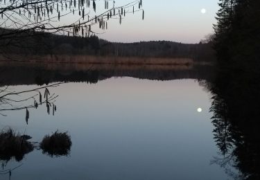
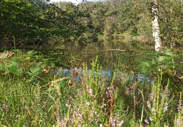
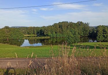
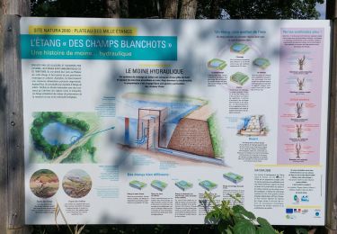
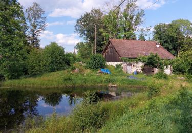
Trail Walking of 19 km to be discovered at Bourgogne-Franche-Comté, Haute-Saône, Esmoulières. This trail is proposed by DanielROLLET.
Description
2018.05.20 - 10:00 à 14:00
Festival de rando "Mille Pas aux Mille Étangs"
1950 participants
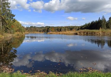
Très beau circuit mais que n'est pas renouvelable car il passe dans des propriétés privées
Arrivée avec la pluie, sinon beau temps couvert.
Positioning
Country:
France
Region :
Bourgogne-Franche-Comté
Department/Province :
Haute-Saône
Municipality :
Esmoulières
Location:
Unknown
Start:(Dec)
Start:(UTM)
321850 ; 5302972 (32T) N.
Comments
Trails nearby
![Trail Walking Beulotte-Saint-Laurent - Randonnée des étangs - Beulotte Saint Laurent - Photo](https://media.geolcdn.com/t/375/260/ext.jpg?maxdim=2&url=https%3A%2F%2Fservices.sitytrail.com%2FGeolivesWS%2FDownloadMedia.ashx%3FTrailID%3D107231%26Media%3D12098_5.jpg)
![Walking Walking](https://static1.geolcdn.com/sitytour/trail-icons/101.png)
Randonnée des étangs - Beulotte Saint Laurent
Walking
Medium
(4)
Beulotte-Saint-Laurent,
Bourgogne-Franche-Comté,
Haute-Saône,
France
![](/images/other/stat-length.png)
10.7 km | 13.9 km-effort
2h 30min
![](https://static1.geolcdn.com/siteimages/upload/files/16400158638029165_repeat_loop_refresh_sync_direction_icon.png)
Yes
![Trail Walking Faucogney-et-la-Mer - 08-02-20 La mer, étang de Pierre Plate et retour. - Photo](https://media.geolcdn.com/t/375/260/1db8c6b9-2ea1-4f8e-aef5-d4d9373f14e8.jpg&format=jpg&maxdim=2)
![Walking Walking](https://static1.geolcdn.com/sitytour/trail-icons/101.png)
08-02-20 La mer, étang de Pierre Plate et retour.
Walking
Very easy
(1)
Faucogney-et-la-Mer,
Bourgogne-Franche-Comté,
Haute-Saône,
France
![](/images/other/stat-length.png)
9.9 km | 12.3 km-effort
2h 4min
![](https://static1.geolcdn.com/siteimages/upload/files/16400158638029165_repeat_loop_refresh_sync_direction_icon.png)
Yes
![Trail Walking Beulotte-Saint-Laurent - Beulotte-Saint-Laurent 13 700m + 317m - Photo](https://media.geolcdn.com/t/375/260/ext.jpg?maxdim=2&url=https%3A%2F%2Fstatic1.geolcdn.com%2Fsiteimages%2Fupload%2Ffiles%2F1553511878bg_sport_marche.png)
![Walking Walking](https://static1.geolcdn.com/sitytour/trail-icons/101.png)
Beulotte-Saint-Laurent 13 700m + 317m
Walking
Easy
(1)
Beulotte-Saint-Laurent,
Bourgogne-Franche-Comté,
Haute-Saône,
France
![](/images/other/stat-length.png)
13.7 km | 17.9 km-effort
3h 50min
![](https://static1.geolcdn.com/siteimages/upload/files/16400158638029165_repeat_loop_refresh_sync_direction_icon.png)
Yes
![Trail Walking Faucogney-et-la-Mer - 07-09-24 Faucogney et étangs - Photo](https://media.geolcdn.com/t/375/260/b632af35-b5e7-4ee3-bdb7-f343582d930c.jpg&format=jpg&maxdim=2)
![Walking Walking](https://static1.geolcdn.com/sitytour/trail-icons/101.png)
07-09-24 Faucogney et étangs
Walking
Medium
Faucogney-et-la-Mer,
Bourgogne-Franche-Comté,
Haute-Saône,
France
![](/images/other/stat-length.png)
9.1 km | 13.4 km-effort
2h 41min
![](https://static1.geolcdn.com/siteimages/upload/files/16400158638029165_repeat_loop_refresh_sync_direction_icon.png)
Yes
![Trail Walking Esmoulières - 08-07-23 circuit du plateau d'Esmoulieres - Photo](https://media.geolcdn.com/t/375/260/21f889c5-6bb0-42f1-a5cd-25c10161a5bd.jpg&format=jpg&maxdim=2)
![Walking Walking](https://static1.geolcdn.com/sitytour/trail-icons/101.png)
08-07-23 circuit du plateau d'Esmoulieres
Walking
Medium
Esmoulières,
Bourgogne-Franche-Comté,
Haute-Saône,
France
![](/images/other/stat-length.png)
8.7 km | 11 km-effort
2h 2min
![](https://static1.geolcdn.com/siteimages/upload/files/16400158638029165_repeat_loop_refresh_sync_direction_icon.png)
Yes
![Trail Walking Esmoulières - Esmoulières rando réelle - Photo](https://media.geolcdn.com/t/375/260/2ad0b972-a66a-4cdb-926e-a4b4f6e7eb9d.jpg&format=jpg&maxdim=2)
![Walking Walking](https://static1.geolcdn.com/sitytour/trail-icons/101.png)
Esmoulières rando réelle
Walking
Medium
Esmoulières,
Bourgogne-Franche-Comté,
Haute-Saône,
France
![](/images/other/stat-length.png)
9.2 km | 11.5 km-effort
3h 11min
![](https://static1.geolcdn.com/siteimages/upload/files/16400158638029165_repeat_loop_refresh_sync_direction_icon.png)
Yes
![Trail Walking Servance-Miellin - 20230616 la petite Finlande - Photo](https://media.geolcdn.com/t/375/260/b19527b0-70e6-4e00-b48b-d0fb85eecf23.jpg&format=jpg&maxdim=2)
![Walking Walking](https://static1.geolcdn.com/sitytour/trail-icons/101.png)
20230616 la petite Finlande
Walking
Medium
Servance-Miellin,
Bourgogne-Franche-Comté,
Haute-Saône,
France
![](/images/other/stat-length.png)
8.4 km | 10 km-effort
3h 25min
![](https://static1.geolcdn.com/siteimages/upload/files/16400158638029165_repeat_loop_refresh_sync_direction_icon.png)
Yes
![Trail sport Amont-et-Effreney - 2023-05-27_12h07m26_randonnee-33932321-effreney-la-noz-du-pin-effreney (3) - Photo](https://media.geolcdn.com/t/375/260/ext.jpg?maxdim=2&url=https%3A%2F%2Fsecurestorage.geolives.com%2Fsitytour%2Ftrail-bg%2Fdefault.jpg)
2023-05-27_12h07m26_randonnee-33932321-effreney-la-noz-du-pin-effreney (3)
sport
Very easy
(1)
Amont-et-Effreney,
Bourgogne-Franche-Comté,
Haute-Saône,
France
![](/images/other/stat-length.png)
18.5 km | 24 km-effort
Unknown
![](https://static1.geolcdn.com/siteimages/upload/files/16400158638029165_repeat_loop_refresh_sync_direction_icon.png)
Yes
![Trail Walking Corravillers - 08-10-22 - Photo](https://media.geolcdn.com/t/375/260/a7db6e7e-6d28-482e-a14b-a0a97cbccd3f.jpg&format=jpg&maxdim=2)
![Walking Walking](https://static1.geolcdn.com/sitytour/trail-icons/101.png)
08-10-22
Walking
Easy
Corravillers,
Bourgogne-Franche-Comté,
Haute-Saône,
France
![](/images/other/stat-length.png)
5.6 km | 7.4 km-effort
1h 44min
![](https://static1.geolcdn.com/siteimages/upload/files/16400158638029165_repeat_loop_refresh_sync_direction_icon.png)
Yes