![](/images/other/stat-length.png)
![Trail Walking Nyons - NYONS (Devès) - Photo](https://media.geolcdn.com/t/1900/400/ext.pjpeg?maxdim=2&url=https%3A%2F%2Fservices.sitytrail.com%2FGeolivesWS%2FDownloadMedia.ashx%3FTrailID%3D966744%26Media%3Dfix__20180515164009.jpg)
NYONS (Devès)
GerardBouche
User
![Length](/images/other/stat-length.png)
Length
7.8 km
![Max alt](https://static1.geolcdn.com/siteimages/upload/files/1508320355ic_sort_altitude_max_24dp.png)
Max alt
519 m
![Uphill gradient](https://static1.geolcdn.com/siteimages/upload/files/1508320355ic_sort_den_pos_24dp.png)
Uphill gradient
267 m
![Km-Effort](/images/other/stat-length.png)
Km-Effort
11.3 km
![Min alt](https://static1.geolcdn.com/siteimages/upload/files/1508320355ic_sort_altitude_min_24dp.png)
Min alt
260 m
![Downhill gradient](https://static1.geolcdn.com/siteimages/upload/files/1508320355ic_sort_den_neg_24dp.png)
Downhill gradient
267 m
![Boucle](https://static1.geolcdn.com/siteimages/upload/files/16400158638029165_repeat_loop_refresh_sync_direction_icon.png)
Boucle
Yes
Creation date :
2018-06-26 14:02:11.919
Updated on :
2018-06-26 14:02:11.919
![Walking](https://static1.geolcdn.com/sitytour/trail-icons/101.png)
2h28
Difficulty : Easy
![Scan this QR Code to open this trail in the SityTrail application](https://capi.geolives.com/qq0zvz2zws4bq2lad0pu/sitytour/trails/966744/qr.png?size=200)
FREE GPS app for hiking
About
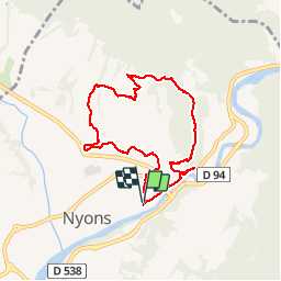
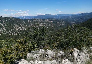
Trail Walking of 7.8 km to be discovered at Auvergne-Rhône-Alpes, Drôme, Nyons. This trail is proposed by GerardBouche.
Description
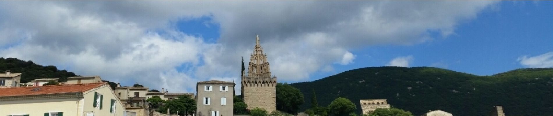
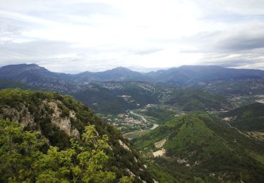
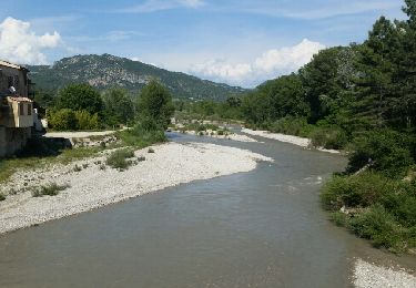
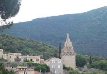
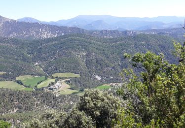
Agréable randonnée par le Pont Roman puis une montée par le sentier du Devès dans la garrigue avec d'innombrables points de vue sur Nyons et les Baronnies.
Au sommet, la chapelle N-D-de-Réparat avant d'entamer la descente par le sentier des oliviers.
Positioning
Country:
France
Region :
Auvergne-Rhône-Alpes
Department/Province :
Drôme
Municipality :
Nyons
Location:
Unknown
Start:(Dec)
Start:(UTM)
670335 ; 4913732 (31T) N.
Comments
Trails nearby
![Trail Walking Nyons - L'Essaillon - Photo](https://media.geolcdn.com/t/375/260/beb3de1a-3f08-4a05-b207-e485690ee2d6.jpg&format=jpg&maxdim=2)
![Walking Walking](https://static1.geolcdn.com/sitytour/trail-icons/101.png)
L'Essaillon
Walking
Difficult
(1)
Nyons,
Auvergne-Rhône-Alpes,
Drôme,
France
![](/images/other/stat-length.png)
17.2 km | 29 km-effort
5h 22min
![](https://static1.geolcdn.com/siteimages/upload/files/16400158638029165_repeat_loop_refresh_sync_direction_icon.png)
Yes
![Trail Walking Les Pilles - NYONS (Monts d'Autuche) - Photo](https://media.geolcdn.com/t/375/260/ext.jpg?maxdim=2&url=https%3A%2F%2Fservices.sitytrail.com%2FGeolivesWS%2FDownloadMedia.ashx%3FTrailID%3D973161%26Media%3Dfix__20180524163427.jpg)
![Walking Walking](https://static1.geolcdn.com/sitytour/trail-icons/101.png)
NYONS (Monts d'Autuche)
Walking
Medium
(1)
Les Pilles,
Auvergne-Rhône-Alpes,
Drôme,
France
![](/images/other/stat-length.png)
9.1 km | 17.9 km-effort
3h 35min
![](https://static1.geolcdn.com/siteimages/upload/files/16400158638029165_repeat_loop_refresh_sync_direction_icon.png)
Yes
![Trail Walking Nyons - NYONS (sentier des Oliviers) - Photo](https://media.geolcdn.com/t/375/260/ext.jpg?maxdim=2&url=https%3A%2F%2Fservices.sitytrail.com%2FGeolivesWS%2FDownloadMedia.ashx%3FTrailID%3D970837%26Media%3Dfix__20180521115311.jpg)
![Walking Walking](https://static1.geolcdn.com/sitytour/trail-icons/101.png)
NYONS (sentier des Oliviers)
Walking
Easy
(1)
Nyons,
Auvergne-Rhône-Alpes,
Drôme,
France
![](/images/other/stat-length.png)
7 km | 10.6 km-effort
2h 13min
![](https://static1.geolcdn.com/siteimages/upload/files/16400158638029165_repeat_loop_refresh_sync_direction_icon.png)
Yes
![Trail Mountain bike Nyons - Espace VTT FFC La Drôme Provençale - Circuit n° 8 - Découverte des Baronnies - Photo](https://media.geolcdn.com/t/375/260/ext.jpg?maxdim=2&url=https%3A%2F%2Fservices.sitytrail.com%2FGeolivesWS%2FDownloadMedia.ashx%3FTrailID%3D101811%26Media%3D2085_2.jpg)
![Mountain bike Mountain bike](https://static1.geolcdn.com/sitytour/trail-icons/202.png)
Espace VTT FFC La Drôme Provençale - Circuit n° 8 - Découverte des Baronnies
Mountain bike
Difficult
(4)
Nyons,
Auvergne-Rhône-Alpes,
Drôme,
France
![](/images/other/stat-length.png)
35 km | 48 km-effort
3h 0min
![](https://static1.geolcdn.com/siteimages/upload/files/16400158638029165_repeat_loop_refresh_sync_direction_icon.png)
Yes
![Trail Walking Nyons - 26 l essaillon Nyons Zel - Photo](https://media.geolcdn.com/t/375/260/0c38f6e5-0ff4-44f9-9732-643c719783ac.jpg&format=jpg&maxdim=2)
![Walking Walking](https://static1.geolcdn.com/sitytour/trail-icons/101.png)
26 l essaillon Nyons Zel
Walking
Medium
Nyons,
Auvergne-Rhône-Alpes,
Drôme,
France
![](/images/other/stat-length.png)
13.3 km | 25 km-effort
6h 45min
![](https://static1.geolcdn.com/siteimages/upload/files/16400158638029165_repeat_loop_refresh_sync_direction_icon.png)
Yes
![Trail Walking Nyons - 26 de Nyons essaillon - Photo](https://media.geolcdn.com/t/375/260/7e1bb091-21b9-4642-a461-e7f5cda8e03d.jpg&format=jpg&maxdim=2)
![Walking Walking](https://static1.geolcdn.com/sitytour/trail-icons/101.png)
26 de Nyons essaillon
Walking
Medium
Nyons,
Auvergne-Rhône-Alpes,
Drôme,
France
![](/images/other/stat-length.png)
13 km | 24 km-effort
5h 46min
![](https://static1.geolcdn.com/siteimages/upload/files/16400158638029165_repeat_loop_refresh_sync_direction_icon.png)
Yes
![Trail Walking Nyons - Montagne de Vaux - Photo](https://media.geolcdn.com/t/375/260/c01719d2-01d4-4a95-ae1d-94db240be52e.jpg&format=jpg&maxdim=2)
![Walking Walking](https://static1.geolcdn.com/sitytour/trail-icons/101.png)
Montagne de Vaux
Walking
Difficult
Nyons,
Auvergne-Rhône-Alpes,
Drôme,
France
![](/images/other/stat-length.png)
20 km | 31 km-effort
7h 27min
![](https://static1.geolcdn.com/siteimages/upload/files/16400158638029165_repeat_loop_refresh_sync_direction_icon.png)
No
![Trail Walking Aubres - aubres - Photo](https://media.geolcdn.com/t/375/260/7d05846c-fe40-45f3-8b74-7336a75fdef1.jpg&format=jpg&maxdim=2)
![Walking Walking](https://static1.geolcdn.com/sitytour/trail-icons/101.png)
aubres
Walking
Medium
Aubres,
Auvergne-Rhône-Alpes,
Drôme,
France
![](/images/other/stat-length.png)
16.3 km | 27 km-effort
6h 39min
![](https://static1.geolcdn.com/siteimages/upload/files/16400158638029165_repeat_loop_refresh_sync_direction_icon.png)
Yes
![Trail Road bike Nyons - boucle nyons buis les barronnies - Photo](https://media.geolcdn.com/t/375/260/ext.jpg?maxdim=2&url=https%3A%2F%2Fstatic1.geolcdn.com%2Fsiteimages%2Fupload%2Ffiles%2F1524743154velo.jpg)
![Road bike Road bike](https://static1.geolcdn.com/sitytour/trail-icons/201.png)
boucle nyons buis les barronnies
Road bike
Very difficult
(1)
Nyons,
Auvergne-Rhône-Alpes,
Drôme,
France
![](/images/other/stat-length.png)
67 km | 80 km-effort
4h 50min
![](https://static1.geolcdn.com/siteimages/upload/files/16400158638029165_repeat_loop_refresh_sync_direction_icon.png)
Yes