![](/images/other/stat-length.png)
![Trail Walking Marmoutier - Marmoutier et forêt du Tannenwald - Photo](https://media.geolcdn.com/t/1900/400/ext.pjpeg?maxdim=2&url=https%3A%2F%2Fservices.sitytrail.com%2FGeolivesWS%2FDownloadMedia.ashx%3FTrailID%3D961429%26Media%3Dfix__20180506144808.jpg)
Marmoutier et forêt du Tannenwald
VacheKiri67
User
![Length](/images/other/stat-length.png)
Length
13.8 km
![Max alt](https://static1.geolcdn.com/siteimages/upload/files/1508320355ic_sort_altitude_max_24dp.png)
Max alt
369 m
![Uphill gradient](https://static1.geolcdn.com/siteimages/upload/files/1508320355ic_sort_den_pos_24dp.png)
Uphill gradient
338 m
![Km-Effort](/images/other/stat-length.png)
Km-Effort
18.3 km
![Min alt](https://static1.geolcdn.com/siteimages/upload/files/1508320355ic_sort_altitude_min_24dp.png)
Min alt
219 m
![Downhill gradient](https://static1.geolcdn.com/siteimages/upload/files/1508320355ic_sort_den_neg_24dp.png)
Downhill gradient
339 m
![Boucle](https://static1.geolcdn.com/siteimages/upload/files/16400158638029165_repeat_loop_refresh_sync_direction_icon.png)
Boucle
Yes
Creation date :
2018-07-27 14:06:41.789
Updated on :
2018-07-27 14:06:41.864
![Walking](https://static1.geolcdn.com/sitytour/trail-icons/101.png)
3h25
Difficulty : Medium
![Scan this QR Code to open this trail in the SityTrail application](https://capi.geolives.com/qq0zvz2zws4bq2lad0pu/sitytour/trails/961429/qr.png?size=200)
FREE GPS app for hiking
About
Trail Walking of 13.8 km to be discovered at Grand Est, Bas-Rhin, Marmoutier. This trail is proposed by VacheKiri67.
Description
Faite le 06/05/2018 avec notre fils Théo de 13 ans. D'après "Autour des abbayes du massif vosgien" N°3 : Du Tannenwald à l'une des plus anciennes abbayes d'Europe. Durée indiquée pour le circuit : 4h. Balisage : anneau bleu.
Positioning
Country:
France
Region :
Grand Est
Department/Province :
Bas-Rhin
Municipality :
Marmoutier
Location:
Unknown
Start:(Dec)
Start:(UTM)
380833 ; 5394369 (32U) N.
Comments
Trails nearby
![Trail Walking Marmoutier - Circuit du Tannenwald - Photo](https://media.geolcdn.com/t/375/260/ext.jpg?maxdim=2&url=https%3A%2F%2Fservices.sitytrail.com%2FGeolivesWS%2FDownloadMedia.ashx%3FTrailID%3D419032%26Media%3Dfix__20150510145209.jpg)
![Walking Walking](https://static1.geolcdn.com/sitytour/trail-icons/101.png)
Circuit du Tannenwald
Walking
Medium
(1)
Marmoutier,
Grand Est,
Bas-Rhin,
France
![](/images/other/stat-length.png)
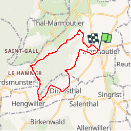
15.4 km | 19.9 km-effort
4h 14min
![](https://static1.geolcdn.com/siteimages/upload/files/16400158638029165_repeat_loop_refresh_sync_direction_icon.png)
Yes
![Trail Walking Reinhardsmunster - 2019-08-15 Marche Schaerferplatz Geissfels Ochsenstein - Photo](https://media.geolcdn.com/t/375/260/99549163-8418-49ab-b342-9e77b4e4ebca.jpg&format=jpg&maxdim=2)
![Walking Walking](https://static1.geolcdn.com/sitytour/trail-icons/101.png)
2019-08-15 Marche Schaerferplatz Geissfels Ochsenstein
Walking
Very difficult
Reinhardsmunster,
Grand Est,
Bas-Rhin,
France
![](/images/other/stat-length.png)
15 km | 23 km-effort
4h 49min
![](https://static1.geolcdn.com/siteimages/upload/files/16400158638029165_repeat_loop_refresh_sync_direction_icon.png)
Yes
![Trail Walking Haegen - Haut Barr-Obersteigen-Haut Barr - Photo](https://media.geolcdn.com/t/375/260/ext.jpg?maxdim=2&url=https%3A%2F%2Fstatic1.geolcdn.com%2Fsiteimages%2Fupload%2Ffiles%2F1553511878bg_sport_marche.png)
![Walking Walking](https://static1.geolcdn.com/sitytour/trail-icons/101.png)
Haut Barr-Obersteigen-Haut Barr
Walking
Medium
(2)
Haegen,
Grand Est,
Bas-Rhin,
France
![](/images/other/stat-length.png)
27 km | 40 km-effort
6h 7min
![](https://static1.geolcdn.com/siteimages/upload/files/16400158638029165_repeat_loop_refresh_sync_direction_icon.png)
Yes
![Trail Walking Marmoutier - Marmoutier - Salenthal - Singrist- Kopp - couvent de Reinacker - Photo](https://media.geolcdn.com/t/375/260/222e1716-a310-4452-97c7-6b3caa2ae3ef.jpg&format=jpg&maxdim=2)
![Walking Walking](https://static1.geolcdn.com/sitytour/trail-icons/101.png)
Marmoutier - Salenthal - Singrist- Kopp - couvent de Reinacker
Walking
Medium
Marmoutier,
Grand Est,
Bas-Rhin,
France
![](/images/other/stat-length.png)
16.2 km | 21 km-effort
4h 16min
![](https://static1.geolcdn.com/siteimages/upload/files/16400158638029165_repeat_loop_refresh_sync_direction_icon.png)
No
![Trail Walking Saverne - château du Haut Barr - GR53 - Photo](https://media.geolcdn.com/t/375/260/86342ba2-e467-45de-9140-58dee4bb1852.jpg&format=jpg&maxdim=2)
![Walking Walking](https://static1.geolcdn.com/sitytour/trail-icons/101.png)
château du Haut Barr - GR53
Walking
Medium
Saverne,
Grand Est,
Bas-Rhin,
France
![](/images/other/stat-length.png)
8.7 km | 12 km-effort
4h 10min
![](https://static1.geolcdn.com/siteimages/upload/files/16400158638029165_repeat_loop_refresh_sync_direction_icon.png)
Yes
![Trail Walking Reinhardsmunster - table des Géants - Photo](https://media.geolcdn.com/t/375/260/a89393af-280e-4d39-a5f5-36a280686cc7.jpg&format=jpg&maxdim=2)
![Walking Walking](https://static1.geolcdn.com/sitytour/trail-icons/101.png)
table des Géants
Walking
Easy
(1)
Reinhardsmunster,
Grand Est,
Bas-Rhin,
France
![](/images/other/stat-length.png)
10.4 km | 14.7 km-effort
3h 6min
![](https://static1.geolcdn.com/siteimages/upload/files/16400158638029165_repeat_loop_refresh_sync_direction_icon.png)
Yes
![Trail Walking Sommerau - Birkenwald Heidenschloss - Photo](https://media.geolcdn.com/t/375/260/da9bbe45-6038-4bd1-845a-cba70c3f9ae7.jpg&format=jpg&maxdim=2)
![Walking Walking](https://static1.geolcdn.com/sitytour/trail-icons/101.png)
Birkenwald Heidenschloss
Walking
Medium
Sommerau,
Grand Est,
Bas-Rhin,
France
![](/images/other/stat-length.png)
12.8 km | 18.1 km-effort
3h 26min
![](https://static1.geolcdn.com/siteimages/upload/files/16400158638029165_repeat_loop_refresh_sync_direction_icon.png)
Yes
![Trail On foot Dimbsthal - Circuit de découverte du Tannenwald - Photo](https://media.geolcdn.com/t/375/260/bdeaff6a-a7e2-455e-aede-3d09eb8e3896.jpeg&format=jpg&maxdim=2)
![On foot On foot](https://static1.geolcdn.com/sitytour/trail-icons/100.png)
Circuit de découverte du Tannenwald
On foot
Easy
Dimbsthal,
Grand Est,
Bas-Rhin,
France
![](/images/other/stat-length.png)
4.9 km | 6.3 km-effort
1h 26min
![](https://static1.geolcdn.com/siteimages/upload/files/16400158638029165_repeat_loop_refresh_sync_direction_icon.png)
No
![Trail Walking Reinhardsmunster - Rheinhardsmunster - Photo](https://media.geolcdn.com/t/375/260/185db358-7189-47b1-8d31-3e839bf3452e.jpg&format=jpg&maxdim=2)
![Walking Walking](https://static1.geolcdn.com/sitytour/trail-icons/101.png)
Rheinhardsmunster
Walking
Difficult
Reinhardsmunster,
Grand Est,
Bas-Rhin,
France
![](/images/other/stat-length.png)
22 km | 31 km-effort
6h 42min
![](https://static1.geolcdn.com/siteimages/upload/files/16400158638029165_repeat_loop_refresh_sync_direction_icon.png)
Yes