Trail Cycle Posthudorra/Porto Torres - Porto Torres -Torre della Pelosa - Photo

Porto Torres -Torre della Pelosa

 egolibre
egolibre

User

© OpenStreetMap contributors
Length
Length
64 km
Max alt
Max alt
54 m
Uphill gradient
Uphill gradient
516 m
Km-Effort
Km-Effort  
71 km
Min alt
Min alt
-2 m
Downhill gradient
Downhill gradient
533 m
Boucle
Boucle
No
Creation date :
2019-03-03 09:52:25.299
Updated on :
2019-03-03 09:52:25.349

(0 Reviews)

Cycle
Cycle
5h26
Difficulty : Easy

Scan this QR Code to open this trail in the SityTrail application

FREE GPS app for hiking

Logo SityTrail SityTrail

IGN / Geographical institutes

Download SityTrail from the App Store Download SityTrail from Google Play

Logo SityTrail SityTrail World

The world is yours!

Download SityTrail from the App Store Download SityTrail from Google Play Download SityTrail on Huawei AppGallery

About

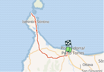
Trail Cycle of 64 km to be discovered at Sardinia, Sassari, Posthudorra/Porto Torres. This trail is proposed by egolibre.

Description

rando velo

Elevation profile

Positioning

Country:
Italy
Region :
Sardinia
Department/Province :
Sassari
Municipality :
Posthudorra/Porto Torres
Location:
Unknown
Start:(UTM)
446431 ; 4518409 (32T) N.

Trails nearby

Trail Bicycle tourism Posthudorra/Porto Torres - Sardaigne 2023 Global - Photo
Bicycle tourism
Mariolebeno

Bicycle tourism

Medium
Posthudorra/Porto Torres, Sardinia, Sassari, Italy
299 km | 337 km-effort
25h 20min
No


Close
My subscriptions