


home in the wall

ben56
User
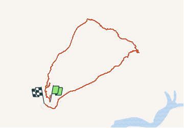

Length
5.7 km

Max alt
918 m

Uphill gradient
164 m
Km-Effort
7.9 km

Min alt
760 m

Downhill gradient
174 m
Boucle
Yes
Creation date :
2018-06-26 12:38:53.503
Updated on :
2018-06-26 12:38:53.503
2h34
Difficulty : Medium

FREE GPS app for hiking
 SityTrail
IGN / Geographical institutes
SityTrail World
The world is yours!
About
Trail Walking of 5.7 km to be discovered at Karas. This trail is proposed by ben56.
Description
namibie
Positioning
Country:
Namibia
Region :
Karas
Department/Province :
Unknown
Municipality :
Unknown
Location:
Unknown
Start:(Dec)
Start:(UTM)
773786 ; 6938324 (33J) S.
Comments
Trails nearby