![](/images/other/stat-length.png)
![Trail Walking Borgloon - Perenboomgaardwandeling - Photo](https://media.geolcdn.com/t/1900/400/ext.pjpeg?maxdim=2&url=https%3A%2F%2Fstatic1.geolcdn.com%2Fsiteimages%2Fupload%2Ffiles%2F1553511878bg_sport_marche.png)
Perenboomgaardwandeling
KristofDM
User
![Length](/images/other/stat-length.png)
Length
8.5 km
![Max alt](https://static1.geolcdn.com/siteimages/upload/files/1508320355ic_sort_altitude_max_24dp.png)
Max alt
74 m
![Uphill gradient](https://static1.geolcdn.com/siteimages/upload/files/1508320355ic_sort_den_pos_24dp.png)
Uphill gradient
49 m
![Km-Effort](/images/other/stat-length.png)
Km-Effort
9.1 km
![Min alt](https://static1.geolcdn.com/siteimages/upload/files/1508320355ic_sort_altitude_min_24dp.png)
Min alt
40 m
![Downhill gradient](https://static1.geolcdn.com/siteimages/upload/files/1508320355ic_sort_den_neg_24dp.png)
Downhill gradient
49 m
![Boucle](https://static1.geolcdn.com/siteimages/upload/files/16400158638029165_repeat_loop_refresh_sync_direction_icon.png)
Boucle
Yes
Creation date :
2019-03-14 17:05:53.401
Updated on :
2019-03-14 17:05:53.416
![Walking](https://static1.geolcdn.com/sitytour/trail-icons/101.png)
2h02
Difficulty : Medium
![Scan this QR Code to open this trail in the SityTrail application](https://capi.geolives.com/qq0zvz2zws4bq2lad0pu/sitytour/trails/949350/qr.png?size=200)
FREE GPS app for hiking
About
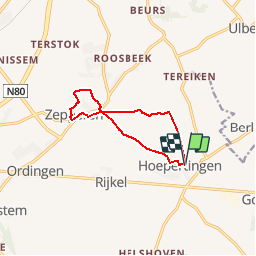
Trail Walking of 8.5 km to be discovered at Flanders, Limburg, Borgloon. This trail is proposed by KristofDM.
Description
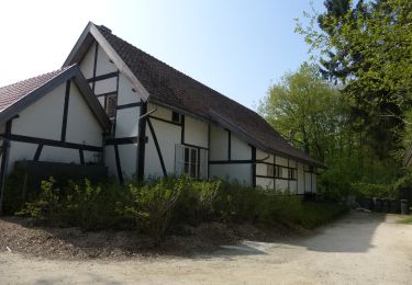
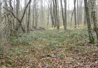
Deze pittoreske wandelroute loodst je door de kasteelomgeving van de kerkdorpjes Hoepertingen en Zepperen. Je passeert boomgaarden die in april volop getooid zijn in de bloesems. In het najaar buigen de takken door onder het gewicht van miljoenen rijpe appels, peren en kersen.
Positioning
Country:
Belgium
Region :
Flanders
Department/Province :
Limburg
Municipality :
Borgloon
Location:
Hoepertingen
Start:(Dec)
Start:(UTM)
661060 ; 5631353 (31U) N.
Comments
Trails nearby
![Trail Walking Borgloon - randonnee de l eglise fantôme (doorkijkkerkje) - Photo](https://media.geolcdn.com/t/375/260/35833fe8-8dcf-4404-b0af-d88e0896892e.jpg&format=jpg&maxdim=2)
![Walking Walking](https://static1.geolcdn.com/sitytour/trail-icons/101.png)
randonnee de l eglise fantôme (doorkijkkerkje)
Walking
Very easy
(2)
Borgloon,
Flanders,
Limburg,
Belgium
![](/images/other/stat-length.png)
8.7 km | 10.5 km-effort
3h 0min
![](https://static1.geolcdn.com/siteimages/upload/files/16400158638029165_repeat_loop_refresh_sync_direction_icon.png)
Yes
![Trail Walking Sint-Truiden - Promenade dans le domaine provincial](https://media.geolcdn.com/t/375/260/b90730e6-26e4-40d2-a400-559a79179cf5.jpg&format=jpg&maxdim=2)
![Walking Walking](https://static1.geolcdn.com/sitytour/trail-icons/101.png)
Promenade dans le domaine provincial "Nieuwenhoven"
Walking
Medium
Sint-Truiden,
Flanders,
Limburg,
Belgium
![](/images/other/stat-length.png)
7.6 km | 8.8 km-effort
1h 59min
![](https://static1.geolcdn.com/siteimages/upload/files/16400158638029165_repeat_loop_refresh_sync_direction_icon.png)
Yes
![Trail On foot Wellen - Alken-Wellen verbinding - Photo](https://media.geolcdn.com/t/375/260/3e82e838-81f6-4f4d-83f3-4708a8447d05.jpeg&format=jpg&maxdim=2)
![On foot On foot](https://static1.geolcdn.com/sitytour/trail-icons/100.png)
Alken-Wellen verbinding
On foot
Easy
Wellen,
Flanders,
Limburg,
Belgium
![](/images/other/stat-length.png)
4.2 km | 4.5 km-effort
1h 1min
![](https://static1.geolcdn.com/siteimages/upload/files/16400158638029165_repeat_loop_refresh_sync_direction_icon.png)
No
![Trail On foot Sint-Truiden - Bernissem wandeling - Photo](https://media.geolcdn.com/t/375/260/da47f886-95ef-4a45-a44c-87cd8463dff7.jpeg&format=jpg&maxdim=2)
![On foot On foot](https://static1.geolcdn.com/sitytour/trail-icons/100.png)
Bernissem wandeling
On foot
Easy
Sint-Truiden,
Flanders,
Limburg,
Belgium
![](/images/other/stat-length.png)
3.3 km | 3.5 km-effort
47min
![](https://static1.geolcdn.com/siteimages/upload/files/16400158638029165_repeat_loop_refresh_sync_direction_icon.png)
Yes
![Trail On foot Borgloon - Perenboomgaardwandeling - Photo](https://media.geolcdn.com/t/375/260/83d08ccc-3d46-4f67-87f8-eb2b08e4c23b.jpeg&format=jpg&maxdim=2)
![On foot On foot](https://static1.geolcdn.com/sitytour/trail-icons/100.png)
Perenboomgaardwandeling
On foot
Easy
Borgloon,
Flanders,
Limburg,
Belgium
![](/images/other/stat-length.png)
8.3 km | 9 km-effort
2h 2min
![](https://static1.geolcdn.com/siteimages/upload/files/16400158638029165_repeat_loop_refresh_sync_direction_icon.png)
Yes
![Trail On foot Wellen - Ulbeek Oranje bol - Photo](https://media.geolcdn.com/t/375/260/38405a42-9cd3-4ec1-97c3-5e4b5875c993.jpeg&format=jpg&maxdim=2)
![On foot On foot](https://static1.geolcdn.com/sitytour/trail-icons/100.png)
![Trail On foot Sint-Truiden - Nieuwenhoven Oranje bol - Photo](https://media.geolcdn.com/t/375/260/b2e64be1-e82e-4959-ae54-cebd0419e976.jpeg&format=jpg&maxdim=2)
![On foot On foot](https://static1.geolcdn.com/sitytour/trail-icons/100.png)
Nieuwenhoven Oranje bol
On foot
Easy
Sint-Truiden,
Flanders,
Limburg,
Belgium
![](/images/other/stat-length.png)
4.4 km | 5.2 km-effort
1h 11min
![](https://static1.geolcdn.com/siteimages/upload/files/16400158638029165_repeat_loop_refresh_sync_direction_icon.png)
Yes
![Trail On foot Sint-Truiden - Nieuwenhoven Blauwe ruit - Photo](https://media.geolcdn.com/t/375/260/b2e64be1-e82e-4959-ae54-cebd0419e976.jpeg&format=jpg&maxdim=2)
![On foot On foot](https://static1.geolcdn.com/sitytour/trail-icons/100.png)
Nieuwenhoven Blauwe ruit
On foot
Easy
Sint-Truiden,
Flanders,
Limburg,
Belgium
![](/images/other/stat-length.png)
3.1 km | 3.6 km-effort
49min
![](https://static1.geolcdn.com/siteimages/upload/files/16400158638029165_repeat_loop_refresh_sync_direction_icon.png)
Yes
![Trail On foot Sint-Truiden - Nieuwenhoven rode driehoek - Photo](https://media.geolcdn.com/t/375/260/ba036578-e487-412c-9b56-087ce0b67338.jpeg&format=jpg&maxdim=2)
![On foot On foot](https://static1.geolcdn.com/sitytour/trail-icons/100.png)
Nieuwenhoven rode driehoek
On foot
Easy
Sint-Truiden,
Flanders,
Limburg,
Belgium
![](/images/other/stat-length.png)
7.6 km | 8.8 km-effort
2h 0min
![](https://static1.geolcdn.com/siteimages/upload/files/16400158638029165_repeat_loop_refresh_sync_direction_icon.png)
Yes