Trail Mountain bike Dommartin-le-Saint-Père - Circuit Le Chavenay - Photo
© OpenStreetMap contributors
Length
Length
16.8 km
Max alt
Max alt
246 m
Uphill gradient
Uphill gradient
220 m
Km-Effort
Km-Effort  
19.7 km
Min alt
Min alt
151 m
Downhill gradient
Downhill gradient
218 m
Boucle
Boucle
Yes
Creation date :
2018-06-26 10:59:11.431
Updated on :
2018-06-26 10:59:11.431

(0 Reviews)

Mountain bike
Mountain bike
2h30
Difficulty : Easy

Scan this QR Code to open this trail in the SityTrail application

FREE GPS app for hiking

Logo SityTrail SityTrail

IGN / Geographical institutes

Download SityTrail from the App Store Download SityTrail from Google Play

Logo SityTrail SityTrail World

The world is yours!

Download SityTrail from the App Store Download SityTrail from Google Play Download SityTrail on Huawei AppGallery

About

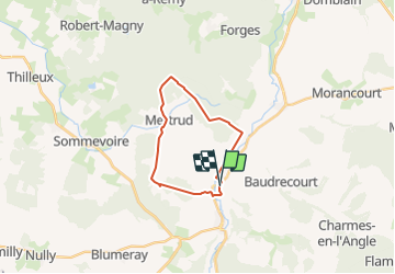
Trail Mountain bike of 16.8 km to be discovered at Grand Est, Haute-Marne, Dommartin-le-Saint-Père. This trail is proposed by delestrai.

Description

Voir fiche d'information www.tourisme-hautemarne.com N° 54

Elevation profile

Positioning

Country:
France
Region :
Grand Est
Department/Province :
Haute-Marne
Municipality :
Dommartin-le-Saint-Père
Location:
Unknown
Start:(UTM)
642289 ; 5361857 (31U) N.

Trails nearby

Trail Walking Mertrud - Mertrud ASLH - Photo
Walking
René Kovac

Walking

Mertrud, Grand Est, Haute-Marne, France
10.4 km | 12.1 km-effort
2h 52min
Yes


Close
My subscriptions