![](/images/other/stat-length.png)
![Trail Walking Wegscheid - le Rossberg et la réserve naturelle de la forêt des volcans depuis Wegscheid - Photo](https://media.geolcdn.com/t/1900/400/ext.pjpeg?maxdim=2&url=https%3A%2F%2Fservices.sitytrail.com%2FGeolivesWS%2FDownloadMedia.ashx%3FTrailID%3D949040%26Media%3Dfix__20180422110755.jpg)
le Rossberg et la réserve naturelle de la forêt des volcans depuis Wegscheid
margotte
User
![Length](/images/other/stat-length.png)
Length
13.7 km
![Max alt](https://static1.geolcdn.com/siteimages/upload/files/1508320355ic_sort_altitude_max_24dp.png)
Max alt
1186 m
![Uphill gradient](https://static1.geolcdn.com/siteimages/upload/files/1508320355ic_sort_den_pos_24dp.png)
Uphill gradient
749 m
![Km-Effort](/images/other/stat-length.png)
Km-Effort
24 km
![Min alt](https://static1.geolcdn.com/siteimages/upload/files/1508320355ic_sort_altitude_min_24dp.png)
Min alt
521 m
![Downhill gradient](https://static1.geolcdn.com/siteimages/upload/files/1508320355ic_sort_den_neg_24dp.png)
Downhill gradient
740 m
![Boucle](https://static1.geolcdn.com/siteimages/upload/files/16400158638029165_repeat_loop_refresh_sync_direction_icon.png)
Boucle
Yes
Creation date :
2019-06-11 14:15:37.449
Updated on :
2020-04-26 15:26:35.722
![Walking](https://static1.geolcdn.com/sitytour/trail-icons/101.png)
4h52
Difficulty : Medium
![Scan this QR Code to open this trail in the SityTrail application](https://capi.geolives.com/qq0zvz2zws4bq2lad0pu/sitytour/trails/949040/qr.png?size=200)
FREE GPS app for hiking
About
Trail Walking of 13.7 km to be discovered at Grand Est, Haut-Rhin, Wegscheid. This trail is proposed by margotte.
Description
super parcours printanier. Nouveau sentier balisé en triangle bleu depuis le Belacker pour le retour en boucle(ce sentier n'existait pas sur ma carte).
Positioning
Country:
France
Region :
Grand Est
Department/Province :
Haut-Rhin
Municipality :
Wegscheid
Location:
Unknown
Start:(Dec)
Start:(UTM)
348070 ; 5297939 (32T) N.
Comments
Trails nearby
![Trail Walking Masevaux-Niederbruck - Masevaux - Rossberg par le belvédère du Fuchsfelsen - Photo](https://media.geolcdn.com/t/375/260/d9cc765c-1250-4953-9d9f-fb8b88eb82a7.jpg&format=jpg&maxdim=2)
![Walking Walking](https://static1.geolcdn.com/sitytour/trail-icons/101.png)
Masevaux - Rossberg par le belvédère du Fuchsfelsen
Walking
Medium
(1)
Masevaux-Niederbruck,
Grand Est,
Haut-Rhin,
France
![](/images/other/stat-length.png)
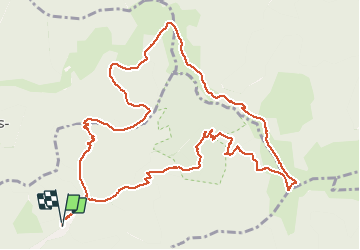
19.9 km | 34 km-effort
4h 44min
![](https://static1.geolcdn.com/siteimages/upload/files/16400158638029165_repeat_loop_refresh_sync_direction_icon.png)
Yes
![Trail Walking Rimbach-près-Masevaux - Haute Bers - Photo](https://media.geolcdn.com/t/375/260/263a149f-9c7c-4184-802a-631c78ca66f6.jpg&format=jpg&maxdim=2)
![Walking Walking](https://static1.geolcdn.com/sitytour/trail-icons/101.png)
Haute Bers
Walking
Medium
(1)
Rimbach-près-Masevaux,
Grand Est,
Haut-Rhin,
France
![](/images/other/stat-length.png)
12 km | 20 km-effort
3h 25min
![](https://static1.geolcdn.com/siteimages/upload/files/16400158638029165_repeat_loop_refresh_sync_direction_icon.png)
Yes
![Trail Walking Sewen - Boucle entre les lacs de Sewen et d'Alfeld - Photo](https://media.geolcdn.com/t/375/260/ext.jpg?maxdim=2&url=https%3A%2F%2Fservices.sitytrail.com%2FGeolivesWS%2FDownloadMedia.ashx%3FTrailID%3D103686%26Media%3D6168_4.jpg)
![Walking Walking](https://static1.geolcdn.com/sitytour/trail-icons/101.png)
Boucle entre les lacs de Sewen et d'Alfeld
Walking
Medium
(1)
Sewen,
Grand Est,
Haut-Rhin,
France
![](/images/other/stat-length.png)
8.1 km | 12.3 km-effort
2h 30min
![](https://static1.geolcdn.com/siteimages/upload/files/16400158638029165_repeat_loop_refresh_sync_direction_icon.png)
Yes
![Trail Walking Storckensohn - lac des perches marchettes - Photo](https://media.geolcdn.com/t/375/260/ba8e93c4-c66a-48b1-88b8-cca79cc3effc.jpg&format=jpg&maxdim=2)
![Walking Walking](https://static1.geolcdn.com/sitytour/trail-icons/101.png)
lac des perches marchettes
Walking
Medium
(1)
Storckensohn,
Grand Est,
Haut-Rhin,
France
![](/images/other/stat-length.png)
11.9 km | 20 km-effort
4h 8min
![](https://static1.geolcdn.com/siteimages/upload/files/16400158638029165_repeat_loop_refresh_sync_direction_icon.png)
Yes
![Trail Walking Storckensohn - 2022-07-16 Marche Auberge Gazon Vert Chapelle des Ves - Photo](https://media.geolcdn.com/t/375/260/7aac2105-88e6-44f1-a6d0-d41240d9f4c5.jpg&format=jpg&maxdim=2)
![Walking Walking](https://static1.geolcdn.com/sitytour/trail-icons/101.png)
2022-07-16 Marche Auberge Gazon Vert Chapelle des Ves
Walking
Very difficult
Storckensohn,
Grand Est,
Haut-Rhin,
France
![](/images/other/stat-length.png)
21 km | 37 km-effort
6h 11min
![](https://static1.geolcdn.com/siteimages/upload/files/16400158638029165_repeat_loop_refresh_sync_direction_icon.png)
No
![Trail Walking Kirchberg - 2022-07-15 Marche Refuge Baerenkopf Auberge Gazon Vert - Photo](https://media.geolcdn.com/t/375/260/d5c191fc-95a3-4bb1-8368-e694339cee76.jpg&format=jpg&maxdim=2)
![Walking Walking](https://static1.geolcdn.com/sitytour/trail-icons/101.png)
2022-07-15 Marche Refuge Baerenkopf Auberge Gazon Vert
Walking
Very difficult
Kirchberg,
Grand Est,
Haut-Rhin,
France
![](/images/other/stat-length.png)
23 km | 38 km-effort
8h 21min
![](https://static1.geolcdn.com/siteimages/upload/files/16400158638029165_repeat_loop_refresh_sync_direction_icon.png)
No
![Trail Walking Rimbach-près-Masevaux - Les deux lacs - Photo](https://media.geolcdn.com/t/375/260/ec102df6-1fd0-42bb-8bbd-9523bd80f1a9.jpg&format=jpg&maxdim=2)
![Walking Walking](https://static1.geolcdn.com/sitytour/trail-icons/101.png)
Les deux lacs
Walking
Difficult
Rimbach-près-Masevaux,
Grand Est,
Haut-Rhin,
France
![](/images/other/stat-length.png)
15.5 km | 25 km-effort
5h 47min
![](https://static1.geolcdn.com/siteimages/upload/files/16400158638029165_repeat_loop_refresh_sync_direction_icon.png)
Yes
![Trail Walking Wegscheid - FucksfelsenBelacker - Photo](https://media.geolcdn.com/t/375/260/ac608221-de91-4d0b-89a9-d4cab6086d15.jpg&format=jpg&maxdim=2)
![Walking Walking](https://static1.geolcdn.com/sitytour/trail-icons/101.png)
FucksfelsenBelacker
Walking
Medium
Wegscheid,
Grand Est,
Haut-Rhin,
France
![](/images/other/stat-length.png)
14.4 km | 24 km-effort
4h 9min
![](https://static1.geolcdn.com/siteimages/upload/files/16400158638029165_repeat_loop_refresh_sync_direction_icon.png)
Yes
![Trail Walking Wegscheid - Sattelboden Stahlberg - Photo](https://media.geolcdn.com/t/375/260/1c077c04-fb86-4fa8-8a55-0d39a1f7ea33.jpg&format=jpg&maxdim=2)
![Walking Walking](https://static1.geolcdn.com/sitytour/trail-icons/101.png)
Sattelboden Stahlberg
Walking
Very difficult
Wegscheid,
Grand Est,
Haut-Rhin,
France
![](/images/other/stat-length.png)
11.9 km | 20 km-effort
4h 35min
![](https://static1.geolcdn.com/siteimages/upload/files/16400158638029165_repeat_loop_refresh_sync_direction_icon.png)
Yes