![](/images/other/stat-length.png)
![Trail Walking Zoutleeuw - Vinnewandeling - 5,5km (witte wandelroute) - Photo](https://media.geolcdn.com/t/1900/400/ext.pjpeg?maxdim=2&url=https%3A%2F%2Fstatic1.geolcdn.com%2Fsiteimages%2Fupload%2Ffiles%2F1553511878bg_sport_marche.png)
Vinnewandeling - 5,5km (witte wandelroute)
KristofDM
User
![Length](/images/other/stat-length.png)
![Max alt](https://static1.geolcdn.com/siteimages/upload/files/1508320355ic_sort_altitude_max_24dp.png)
![Uphill gradient](https://static1.geolcdn.com/siteimages/upload/files/1508320355ic_sort_den_pos_24dp.png)
![Km-Effort](/images/other/stat-length.png)
![Min alt](https://static1.geolcdn.com/siteimages/upload/files/1508320355ic_sort_altitude_min_24dp.png)
![Downhill gradient](https://static1.geolcdn.com/siteimages/upload/files/1508320355ic_sort_den_neg_24dp.png)
![Boucle](https://static1.geolcdn.com/siteimages/upload/files/16400158638029165_repeat_loop_refresh_sync_direction_icon.png)
![Walking](https://static1.geolcdn.com/sitytour/trail-icons/101.png)
55m
Difficulty : Easy
![Scan this QR Code to open this trail in the SityTrail application](https://capi.geolives.com/qq0zvz2zws4bq2lad0pu/sitytour/trails/948101/qr.png?size=200)
FREE GPS app for hiking
About
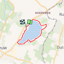
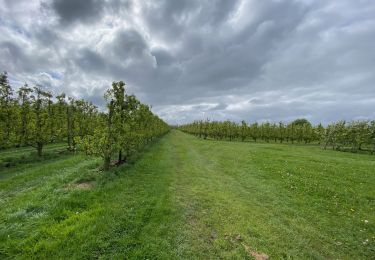
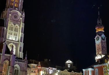
Trail Walking of 4.4 km to be discovered at Flanders, Flemish Brabant, Zoutleeuw. This trail is proposed by KristofDM.
Description
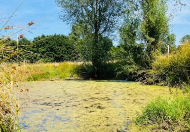
Door een samenspel van klimaat en bodemgesteldheid werd op het einde van de laatste ijstijd een komvormige laagte uitgeschuurd in Het Vinne. Zo ontstond een natuurlijk meer. Het meer werd via twee beken (de Sint-Odulphusbeek en de Vinnebeek) voorzien van extra water. Nadat het gebied meer dan 100 jaar drooggelegd was, werd in 2004 het grootste natuurlijke binnenmeer van Vlaanderen terug in zijn oorspronkelijke staat hersteld. Er ontstond opnieuw een open waterplas met brede oevers waar rietkragen en broekbossen tot ontwikkeling komen. De licht hellende oevers van het meer zijn ideaal voor een rijke variatie van oeverplanten met veel schuilgelegenheid voor waterfauna. Het Vinne ligt ook op een belangrijke vogeltrekroute en is dus zeer interessant voor langskomende trekvogels.
Points of interest
Positioning
Comments
Trails nearby
![Trail Walking Zoutleeuw - Zoutleeuw 16 km - Photo](https://media.geolcdn.com/t/375/260/b3a37ac3-8fca-4eba-bd9d-831054990cdb.jpg&format=jpg&maxdim=2)
![Walking Walking](https://static1.geolcdn.com/sitytour/trail-icons/101.png)
Walking
![](/images/other/stat-length.png)
![](https://static1.geolcdn.com/siteimages/upload/files/16400158638029165_repeat_loop_refresh_sync_direction_icon.png)
![Trail On foot Sint-Truiden - Staaien rode driehoek - Photo](https://media.geolcdn.com/t/375/260/cd3d1f60-3cd2-4539-a2b4-06ec7df817c9.jpeg&format=jpg&maxdim=2)
![On foot On foot](https://static1.geolcdn.com/sitytour/trail-icons/100.png)
On foot
![](/images/other/stat-length.png)
![](https://static1.geolcdn.com/siteimages/upload/files/16400158638029165_repeat_loop_refresh_sync_direction_icon.png)
![Trail On foot Sint-Truiden - Staaien oranje bol - Photo](https://media.geolcdn.com/t/375/260/7b137b54-411c-4e68-8c6c-aeb3fad0dd86.jpeg&format=jpg&maxdim=2)
![On foot On foot](https://static1.geolcdn.com/sitytour/trail-icons/100.png)
On foot
![](/images/other/stat-length.png)
![](https://static1.geolcdn.com/siteimages/upload/files/16400158638029165_repeat_loop_refresh_sync_direction_icon.png)
![Trail Walking Linter - Melkwezer Haspengouw GroteGetewandeling - 11 km RT - Photo](https://media.geolcdn.com/t/375/260/ext.jpg?maxdim=2&url=https%3A%2F%2Fstatic1.geolcdn.com%2Fsiteimages%2Fupload%2Ffiles%2F1553511878bg_sport_marche.png)
![Walking Walking](https://static1.geolcdn.com/sitytour/trail-icons/101.png)
Walking
![](/images/other/stat-length.png)
![](https://static1.geolcdn.com/siteimages/upload/files/16400158638029165_repeat_loop_refresh_sync_direction_icon.png)
![Trail Walking Zoutleeuw - S-GR Hageland : Terhagen - Diest - Photo](https://media.geolcdn.com/t/375/260/0bcaa454-b723-4dae-8870-b6599e62c5b1.jpeg&format=jpg&maxdim=2)
![Walking Walking](https://static1.geolcdn.com/sitytour/trail-icons/101.png)
Walking
![](/images/other/stat-length.png)
![](https://static1.geolcdn.com/siteimages/upload/files/16400158638029165_repeat_loop_refresh_sync_direction_icon.png)
![Trail Walking Sint-Truiden - La petite église de Guvelingen à Saint-Trond - Photo](https://media.geolcdn.com/t/375/260/2dfbb9e1-f6fd-446e-ac63-6ef5fef7f407.jpeg&format=jpg&maxdim=2)
![Walking Walking](https://static1.geolcdn.com/sitytour/trail-icons/101.png)
Walking
![](/images/other/stat-length.png)
![](https://static1.geolcdn.com/siteimages/upload/files/16400158638029165_repeat_loop_refresh_sync_direction_icon.png)
![Trail Walking Sint-Truiden - La reserve naturelle Op d’Hei à Runkelen - Photo](https://media.geolcdn.com/t/375/260/66426e65-b121-47ad-be3c-c041b27709ce.jpeg&format=jpg&maxdim=2)
![Walking Walking](https://static1.geolcdn.com/sitytour/trail-icons/101.png)
Walking
![](/images/other/stat-length.png)
![](https://static1.geolcdn.com/siteimages/upload/files/16400158638029165_repeat_loop_refresh_sync_direction_icon.png)
![Trail Walking Sint-Truiden - La vallée fruitière à Saint-Trond - Photo](https://media.geolcdn.com/t/375/260/1eb5917c-9ec1-4729-bf31-3ca14ced1caa.jpg&format=jpg&maxdim=2)
![Walking Walking](https://static1.geolcdn.com/sitytour/trail-icons/101.png)
Walking
![](/images/other/stat-length.png)
![](https://static1.geolcdn.com/siteimages/upload/files/16400158638029165_repeat_loop_refresh_sync_direction_icon.png)
![Trail Walking Sint-Truiden - Evenement](https://media.geolcdn.com/t/375/260/af01bbc1-1427-44e0-8703-722b0cf9517e.jpeg&format=jpg&maxdim=2)
![Walking Walking](https://static1.geolcdn.com/sitytour/trail-icons/101.png)
Walking
![](/images/other/stat-length.png)
![](https://static1.geolcdn.com/siteimages/upload/files/16400158638029165_repeat_loop_refresh_sync_direction_icon.png)