![](/images/other/stat-length.png)
![Trail Cycle Metz - 2018-04-18 - Maison du vélo - Promenade du Gué - Photo](https://media.geolcdn.com/t/1900/400/ext.pjpeg?maxdim=2&url=https%3A%2F%2Fstatic1.geolcdn.com%2Fsiteimages%2Fupload%2Ffiles%2F1524743154velo.jpg)
2018-04-18 - Maison du vélo - Promenade du Gué
edmondnagel
User
![Length](/images/other/stat-length.png)
Length
19.4 km
![Max alt](https://static1.geolcdn.com/siteimages/upload/files/1508320355ic_sort_altitude_max_24dp.png)
Max alt
191 m
![Uphill gradient](https://static1.geolcdn.com/siteimages/upload/files/1508320355ic_sort_den_pos_24dp.png)
Uphill gradient
144 m
![Km-Effort](/images/other/stat-length.png)
Km-Effort
21 km
![Min alt](https://static1.geolcdn.com/siteimages/upload/files/1508320355ic_sort_altitude_min_24dp.png)
Min alt
162 m
![Downhill gradient](https://static1.geolcdn.com/siteimages/upload/files/1508320355ic_sort_den_neg_24dp.png)
Downhill gradient
143 m
![Boucle](https://static1.geolcdn.com/siteimages/upload/files/16400158638029165_repeat_loop_refresh_sync_direction_icon.png)
Boucle
Yes
Creation date :
2018-04-18 00:41:03.838
Updated on :
2018-04-18 00:41:03.838
![Cycle](https://static1.geolcdn.com/sitytour/trail-icons/200.png)
1h14
Difficulty : Easy
![Scan this QR Code to open this trail in the SityTrail application](https://capi.geolives.com/qq0zvz2zws4bq2lad0pu/sitytour/trails/944348/qr.png?size=200)
FREE GPS app for hiking
About
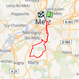
Trail Cycle of 19.4 km to be discovered at Grand Est, Moselle, Metz. This trail is proposed by edmondnagel.
Description
Départ Maison du vélo en longeant la Seille rive droite, Promenade du Gué à Magny rive droite de la Seille, Les Hameaux du Golf à Marly, retour par la rue de Metz, le Chemin de Blory, Promenade du Gué, rive gauche de la Seille
Positioning
Country:
France
Region :
Grand Est
Department/Province :
Moselle
Municipality :
Metz
Location:
Unknown
Start:(Dec)
Start:(UTM)
294409 ; 5444595 (32U) N.
Comments
Trails nearby
![Trail Walking Plappeville - Saint Quentin - Photo](https://media.geolcdn.com/t/375/260/ext.jpg?maxdim=2&url=https%3A%2F%2Fservices.sitytrail.com%2FGeolivesWS%2FDownloadMedia.ashx%3FTrailID%3D159776%26Media%3D20121024120133.jpg)
![Walking Walking](https://static1.geolcdn.com/sitytour/trail-icons/101.png)
Saint Quentin
Walking
Medium
(1)
Plappeville,
Grand Est,
Moselle,
France
![](/images/other/stat-length.png)
6.9 km | 9.2 km-effort
1h 59min
![](https://static1.geolcdn.com/siteimages/upload/files/16400158638029165_repeat_loop_refresh_sync_direction_icon.png)
Yes
![Trail Walking Plappeville - Autour du fort de Plappeville. - Photo](https://media.geolcdn.com/t/375/260/ext.jpg?maxdim=2&url=https%3A%2F%2Fservices.sitytrail.com%2FGeolivesWS%2FDownloadMedia.ashx%3FTrailID%3D147559%26Media%3D20120816102740.jpg)
![Walking Walking](https://static1.geolcdn.com/sitytour/trail-icons/101.png)
Autour du fort de Plappeville.
Walking
Easy
(1)
Plappeville,
Grand Est,
Moselle,
France
![](/images/other/stat-length.png)
8.9 km | 11 km-effort
2h 55min
![](https://static1.geolcdn.com/siteimages/upload/files/16400158638029165_repeat_loop_refresh_sync_direction_icon.png)
Yes
![Trail On foot Metz - Circuit des sentiers de Queuleu - Photo](https://media.geolcdn.com/t/375/260/e8f5cc79-0435-4c0e-abc8-879d05da612b.jpeg&format=jpg&maxdim=2)
![On foot On foot](https://static1.geolcdn.com/sitytour/trail-icons/100.png)
Circuit des sentiers de Queuleu
On foot
Easy
Metz,
Grand Est,
Moselle,
France
![](/images/other/stat-length.png)
4.5 km | 5.2 km-effort
1h 10min
![](https://static1.geolcdn.com/siteimages/upload/files/16400158638029165_repeat_loop_refresh_sync_direction_icon.png)
Yes
![Trail On foot Scy-Chazelles - Circuit du Tour du Mont St Quentin - Photo](https://media.geolcdn.com/t/375/260/0227a6bb-ecc7-41f2-b92a-b603e3858c5b.jpeg&format=jpg&maxdim=2)
![On foot On foot](https://static1.geolcdn.com/sitytour/trail-icons/100.png)
Circuit du Tour du Mont St Quentin
On foot
Easy
Scy-Chazelles,
Grand Est,
Moselle,
France
![](/images/other/stat-length.png)
4.9 km | 6.7 km-effort
1h 31min
![](https://static1.geolcdn.com/siteimages/upload/files/16400158638029165_repeat_loop_refresh_sync_direction_icon.png)
No
![Walking Walking](https://static1.geolcdn.com/sitytour/trail-icons/101.png)
20210723 - METZ - Promenade des remparts - 6 Km
Walking
Very easy
Metz,
Grand Est,
Moselle,
France
![](/images/other/stat-length.png)
5.7 km | 6.6 km-effort
1h 45min
![](https://static1.geolcdn.com/siteimages/upload/files/16400158638029165_repeat_loop_refresh_sync_direction_icon.png)
Yes
![Trail Mountain bike Metz - MetzGare-PAM - Photo](https://media.geolcdn.com/t/375/260/ext.jpg?maxdim=2&url=https%3A%2F%2Fstatic1.geolcdn.com%2Fsiteimages%2Fupload%2Ffiles%2F1524743154velo.jpg)
![Mountain bike Mountain bike](https://static1.geolcdn.com/sitytour/trail-icons/202.png)
MetzGare-PAM
Mountain bike
Easy
(1)
Metz,
Grand Est,
Moselle,
France
![](/images/other/stat-length.png)
30 km | 33 km-effort
Unknown
![](https://static1.geolcdn.com/siteimages/upload/files/16400158638029165_repeat_loop_refresh_sync_direction_icon.png)
No
![Trail Walking Longeville-lès-Metz - Metz - Les fortifications & 🎅🎄 - Photo](https://media.geolcdn.com/t/375/260/78c4f220-2684-42e2-8e51-0cc7754dd491.jpg&format=jpg&maxdim=2)
![Walking Walking](https://static1.geolcdn.com/sitytour/trail-icons/101.png)
Metz - Les fortifications & 🎅🎄
Walking
Easy
Longeville-lès-Metz,
Grand Est,
Moselle,
France
![](/images/other/stat-length.png)
11.2 km | 12.9 km-effort
2h 41min
![](https://static1.geolcdn.com/siteimages/upload/files/16400158638029165_repeat_loop_refresh_sync_direction_icon.png)
Yes
![Trail Walking Longeville-lès-Metz - 🎅🎄 Noël à Metz - Photo](https://media.geolcdn.com/t/375/260/5af36f19-04a2-474a-9a82-8a9aed35e003.jpg&format=jpg&maxdim=2)
![Walking Walking](https://static1.geolcdn.com/sitytour/trail-icons/101.png)
🎅🎄 Noël à Metz
Walking
Easy
Longeville-lès-Metz,
Grand Est,
Moselle,
France
![](/images/other/stat-length.png)
14.5 km | 16.5 km-effort
3h 54min
![](https://static1.geolcdn.com/siteimages/upload/files/16400158638029165_repeat_loop_refresh_sync_direction_icon.png)
Yes
![Trail Equestrian Woippy - Vers chez Sam - Photo](https://media.geolcdn.com/t/375/260/ext.jpg?maxdim=2&url=https%3A%2F%2Fstatic1.geolcdn.com%2Fsiteimages%2Fupload%2Ffiles%2F1524743154cheval.jpg)
![Equestrian Equestrian](https://static1.geolcdn.com/sitytour/trail-icons/300.png)
Vers chez Sam
Equestrian
Very easy
(1)
Woippy,
Grand Est,
Moselle,
France
![](/images/other/stat-length.png)
9.3 km | 12.3 km-effort
Unknown
![](https://static1.geolcdn.com/siteimages/upload/files/16400158638029165_repeat_loop_refresh_sync_direction_icon.png)
No