![](/images/other/stat-length.png)
![Trail Other activity Bierbeek - De Schavaaiwandeling in Bierbeek - Photo](https://media.geolcdn.com/t/1900/400/ext.pjpeg?maxdim=2&url=https%3A%2F%2Fstatic1.geolcdn.com%2Fsiteimages%2Fupload%2Ffiles%2F1545311037marcheuse_200dpi.jpg)
De Schavaaiwandeling in Bierbeek
Swakke
User
![Length](/images/other/stat-length.png)
![Max alt](https://static1.geolcdn.com/siteimages/upload/files/1508320355ic_sort_altitude_max_24dp.png)
![Uphill gradient](https://static1.geolcdn.com/siteimages/upload/files/1508320355ic_sort_den_pos_24dp.png)
![Km-Effort](/images/other/stat-length.png)
![Min alt](https://static1.geolcdn.com/siteimages/upload/files/1508320355ic_sort_altitude_min_24dp.png)
![Downhill gradient](https://static1.geolcdn.com/siteimages/upload/files/1508320355ic_sort_den_neg_24dp.png)
![Boucle](https://static1.geolcdn.com/siteimages/upload/files/16400158638029165_repeat_loop_refresh_sync_direction_icon.png)
![Other activity](https://static1.geolcdn.com/sitytour/trail-icons/900.png)
--
Difficulty : Unknown
![Scan this QR Code to open this trail in the SityTrail application](https://capi.geolives.com/qq0zvz2zws4bq2lad0pu/sitytour/trails/942014/qr.png?size=200)
FREE GPS app for hiking
About
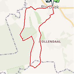
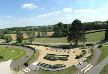
Trail Other activity of 7.7 km to be discovered at Flanders, Flemish Brabant, Bierbeek. This trail is proposed by Swakke.
Description
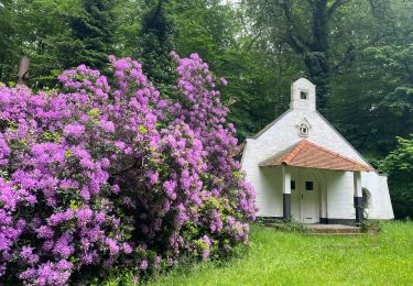
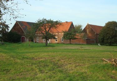
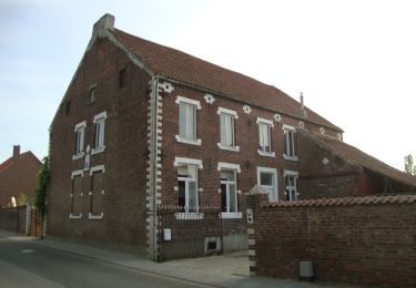
Zoals de naam Bierbeek laat vermoeden is het dorp gelegen aan een beek: de Mollendaalbeek. Ze ontspringt in het gelijknamige gehucht, op 1 km ten zuiden van de dorpskom. De omgeving van Mollendaal is één van de meest landelijke gebieden van Bierbeek. Wijde akkers en fraaie hoeven duiden aan dat de grond er zeer vruchtbaar is. De naam 'Schavaai' betekent in het lokale dialect mutsaard, takkenbos. Waarschijnlijker is nochtans dat de plaatsnaam een vervorming is van het Romaanse woord 'scavée' dat op zijn beurt afgeleid is van het Latijnse excavata, wat groeve betekent.
bron: Op stap in Vlaams-Brabant-Dijleland-15 wandelingen, Toeristische Federatie van Vlaams-Brabant, 1997, Leuven.
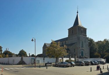
Vertrekpunt en parkeerplaats:
Sint - Hilariuskerk, Dorpsstraat, Bierbeek
OV: Leuven Station perron 3 - Lijn 6
Bewegwijzering: zeshoekige wit-rodeplaatjes
Positioning
Comments
Trails nearby
![Walking Walking](https://static1.geolcdn.com/sitytour/trail-icons/101.png)
Walking
![](/images/other/stat-length.png)
![](https://static1.geolcdn.com/siteimages/upload/files/16400158638029165_repeat_loop_refresh_sync_direction_icon.png)
![Trail Walking Oud-Heverlee - Meerdaalwoud - Photo](https://media.geolcdn.com/t/375/260/ext.jpg?maxdim=2&url=https%3A%2F%2Fservices.sitytrail.com%2FGeolivesWS%2FDownloadMedia.ashx%3FTrailID%3D591604%26Media%3D20160612095926.jpg)
![Walking Walking](https://static1.geolcdn.com/sitytour/trail-icons/101.png)
Walking
![](/images/other/stat-length.png)
![](https://static1.geolcdn.com/siteimages/upload/files/16400158638029165_repeat_loop_refresh_sync_direction_icon.png)
![Trail Mountain bike Oud-Heverlee - Meerdael - Photo](https://media.geolcdn.com/t/375/260/ext.jpg?maxdim=2&url=https%3A%2F%2Fstatic1.geolcdn.com%2Fsiteimages%2Fupload%2Ffiles%2F1524743154velo.jpg)
![Mountain bike Mountain bike](https://static1.geolcdn.com/sitytour/trail-icons/202.png)
Mountain bike
![](/images/other/stat-length.png)
![](https://static1.geolcdn.com/siteimages/upload/files/16400158638029165_repeat_loop_refresh_sync_direction_icon.png)
![Trail On foot Bierbeek - Walterpad variant B - Photo](https://media.geolcdn.com/t/375/260/97f167cf-343d-4614-b53d-0bf567721674.jpeg&format=jpg&maxdim=2)
![On foot On foot](https://static1.geolcdn.com/sitytour/trail-icons/100.png)
On foot
![](/images/other/stat-length.png)
![](https://static1.geolcdn.com/siteimages/upload/files/16400158638029165_repeat_loop_refresh_sync_direction_icon.png)
![Trail On foot Bierbeek - Walterpad variant A - Photo](https://media.geolcdn.com/t/375/260/9d093022-83a0-407b-8940-77a39f7cbc36.jpeg&format=jpg&maxdim=2)
![On foot On foot](https://static1.geolcdn.com/sitytour/trail-icons/100.png)
On foot
![](/images/other/stat-length.png)
![](https://static1.geolcdn.com/siteimages/upload/files/16400158638029165_repeat_loop_refresh_sync_direction_icon.png)
![Trail On foot Bierbeek - Hollewegenwandelpad - Photo](https://media.geolcdn.com/t/375/260/58a21a26-c364-46a8-866b-beae515c5750.jpeg&format=jpg&maxdim=2)
![On foot On foot](https://static1.geolcdn.com/sitytour/trail-icons/100.png)
On foot
![](/images/other/stat-length.png)
![](https://static1.geolcdn.com/siteimages/upload/files/16400158638029165_repeat_loop_refresh_sync_direction_icon.png)
![Trail On foot Boutersem - Kleine Kringwandelpad - Photo](https://media.geolcdn.com/t/375/260/921c562e-84e1-448b-b0e1-9555ca637c1e.jpeg&format=jpg&maxdim=2)
![On foot On foot](https://static1.geolcdn.com/sitytour/trail-icons/100.png)
On foot
![](/images/other/stat-length.png)
![](https://static1.geolcdn.com/siteimages/upload/files/16400158638029165_repeat_loop_refresh_sync_direction_icon.png)
![Trail On foot Boutersem - Velpehoevewandelpad - Photo](https://media.geolcdn.com/t/375/260/32694a94-9124-4a9f-8730-155bd3fc653c.jpeg&format=jpg&maxdim=2)
![On foot On foot](https://static1.geolcdn.com/sitytour/trail-icons/100.png)
On foot
![](/images/other/stat-length.png)
![](https://static1.geolcdn.com/siteimages/upload/files/16400158638029165_repeat_loop_refresh_sync_direction_icon.png)
![Trail On foot Lubbeek - Koebos Rode driehoek - Photo](https://media.geolcdn.com/t/375/260/5c20d123-ec17-4589-930d-f0e497ca53fb.jpeg&format=jpg&maxdim=2)
![On foot On foot](https://static1.geolcdn.com/sitytour/trail-icons/100.png)
On foot
![](/images/other/stat-length.png)
![](https://static1.geolcdn.com/siteimages/upload/files/16400158638029165_repeat_loop_refresh_sync_direction_icon.png)