![](/images/other/stat-length.png)
![Trail Walking Hastière - Promenade 21 - Le Ladigan - Le Traillis - Le Belvédère (O.T. Hastière) - Photo](https://media.geolcdn.com/t/1900/400/ext.pjpeg?maxdim=2&url=https%3A%2F%2Fstatic1.geolcdn.com%2Fsiteimages%2Fupload%2Ffiles%2F1553511878bg_sport_marche.png)
Promenade 21 - Le Ladigan - Le Traillis - Le Belvédère (O.T. Hastière)
ValleedelaMeuse
User
![Length](/images/other/stat-length.png)
Length
4.8 km
![Max alt](https://static1.geolcdn.com/siteimages/upload/files/1508320355ic_sort_altitude_max_24dp.png)
Max alt
248 m
![Uphill gradient](https://static1.geolcdn.com/siteimages/upload/files/1508320355ic_sort_den_pos_24dp.png)
Uphill gradient
187 m
![Km-Effort](/images/other/stat-length.png)
Km-Effort
7.3 km
![Min alt](https://static1.geolcdn.com/siteimages/upload/files/1508320355ic_sort_altitude_min_24dp.png)
Min alt
94 m
![Downhill gradient](https://static1.geolcdn.com/siteimages/upload/files/1508320355ic_sort_den_neg_24dp.png)
Downhill gradient
187 m
![Boucle](https://static1.geolcdn.com/siteimages/upload/files/16400158638029165_repeat_loop_refresh_sync_direction_icon.png)
Boucle
Yes
![Signpost](https://services.sitytrail.com/GeolivesWS/DownloadMedia.ashx?TrailID=941633&Media=balise.png)
Signpost
Creation date :
2018-04-18 00:19:27.071
Updated on :
2018-04-18 00:19:27.071
![Walking](https://static1.geolcdn.com/sitytour/trail-icons/101.png)
1h39
Difficulty : Difficult
![Scan this QR Code to open this trail in the SityTrail application](https://capi.geolives.com/qq0zvz2zws4bq2lad0pu/sitytour/trails/941633/qr.png?size=200)
FREE GPS app for hiking
About
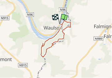
Trail Walking of 4.8 km to be discovered at Wallonia, Namur, Hastière. This trail is proposed by ValleedelaMeuse.
Description
Extrait de la carte des promenades pédestres sur fond IGN au 1/25.000e éditée par l'O.T. Hastière, reprenant 23 circuits balisés avec descriptif complet bilingue au verso. Carte en vente à l'O.T. Hastière et à la Maison du Tourisme au prix de 7,- euros. Infos sur www.hastiere-tourisme.be
Positioning
Country:
Belgium
Region :
Wallonia
Department/Province :
Namur
Municipality :
Hastière
Location:
Waulsort
Start:(Dec)
Start:(UTM)
633231 ; 5563035 (31U) N.
Comments
Trails nearby
![Walking Walking](https://static1.geolcdn.com/sitytour/trail-icons/101.png)
RB-Na-24-Entre Lesse et Meuse
Walking
Very difficult
(15)
Dinant,
Wallonia,
Namur,
Belgium
![](/images/other/stat-length.png)
19.3 km | 26 km-effort
5h 57min
![](https://static1.geolcdn.com/siteimages/upload/files/16400158638029165_repeat_loop_refresh_sync_direction_icon.png)
Yes
![Trail Walking Hastière - Balade de Hastière à Waulsort - Photo](https://media.geolcdn.com/t/375/260/ext.jpg?maxdim=2&url=https%3A%2F%2Fservices.sitytrail.com%2FGeolivesWS%2FDownloadMedia.ashx%3FTrailID%3D387141%26Media%3D8deb5256-25c7-4e2f-8aa7-6385d313d678.JPG)
![Walking Walking](https://static1.geolcdn.com/sitytour/trail-icons/101.png)
Balade de Hastière à Waulsort
Walking
Medium
(2)
Hastière,
Wallonia,
Namur,
Belgium
![](/images/other/stat-length.png)
10.8 km | 13.8 km-effort
3h 2min
![](https://static1.geolcdn.com/siteimages/upload/files/16400158638029165_repeat_loop_refresh_sync_direction_icon.png)
Yes
![Trail Walking Dinant - D'Anseremme à Dinant - Photo](https://media.geolcdn.com/t/375/260/ext.jpg?maxdim=2&url=https%3A%2F%2Fservices.sitytrail.com%2FGeolivesWS%2FDownloadMedia.ashx%3FTrailID%3D375788%26Media%3D9ffb86bd-da6e-4936-82b7-07dbdf349394.JPG)
![Walking Walking](https://static1.geolcdn.com/sitytour/trail-icons/101.png)
D'Anseremme à Dinant
Walking
Easy
(3)
Dinant,
Wallonia,
Namur,
Belgium
![](/images/other/stat-length.png)
8.3 km | 11.8 km-effort
2h 34min
![](https://static1.geolcdn.com/siteimages/upload/files/16400158638029165_repeat_loop_refresh_sync_direction_icon.png)
Yes
![Trail Walking Hastière - RB-Na-10 Raccourci 2 - Sur les crêtes mosanes - Photo](https://media.geolcdn.com/t/375/260/ext.jpg?maxdim=2&url=https%3A%2F%2Fservices.sitytrail.com%2FGeolivesWS%2FDownloadMedia.ashx%3FTrailID%3D213761%26Media%3D916a806e-df9c-467d-9e17-3d2c79318b74.jpg)
![Walking Walking](https://static1.geolcdn.com/sitytour/trail-icons/101.png)
RB-Na-10 Raccourci 2 - Sur les crêtes mosanes
Walking
Easy
(2)
Hastière,
Wallonia,
Namur,
Belgium
![](/images/other/stat-length.png)
18.1 km | 25 km-effort
4h 29min
![](https://static1.geolcdn.com/siteimages/upload/files/16400158638029165_repeat_loop_refresh_sync_direction_icon.png)
Yes
![Trail Walking Hastière - RB-Na-10 Raccourci 1 - Sur les crêtes mosanes - Photo](https://media.geolcdn.com/t/375/260/ext.jpg?maxdim=2&url=https%3A%2F%2Fservices.sitytrail.com%2FGeolivesWS%2FDownloadMedia.ashx%3FTrailID%3D213760%26Media%3D343ebbcb-0af7-4afb-9c83-addaf37a523a.jpg)
![Walking Walking](https://static1.geolcdn.com/sitytour/trail-icons/101.png)
RB-Na-10 Raccourci 1 - Sur les crêtes mosanes
Walking
Medium
(3)
Hastière,
Wallonia,
Namur,
Belgium
![](/images/other/stat-length.png)
15.3 km | 21 km-effort
5h 28min
![](https://static1.geolcdn.com/siteimages/upload/files/16400158638029165_repeat_loop_refresh_sync_direction_icon.png)
Yes
![Trail Walking Hastière - RB-Na-10 - Sur les crêtes mosanes - Photo](https://media.geolcdn.com/t/375/260/ext.jpg?maxdim=2&url=https%3A%2F%2Fservices.sitytrail.com%2FGeolivesWS%2FDownloadMedia.ashx%3FTrailID%3D179636%26Media%3Db1540aaa-f9ca-4d3f-a5e9-5e8de7ac00b3.jpg)
![Walking Walking](https://static1.geolcdn.com/sitytour/trail-icons/101.png)
RB-Na-10 - Sur les crêtes mosanes
Walking
Medium
(5)
Hastière,
Wallonia,
Namur,
Belgium
![](/images/other/stat-length.png)
22 km | 29 km-effort
6h 21min
![](https://static1.geolcdn.com/siteimages/upload/files/16400158638029165_repeat_loop_refresh_sync_direction_icon.png)
Yes
![Walking Walking](https://static1.geolcdn.com/sitytour/trail-icons/101.png)
RB-Na-24-racc-Entre Lesse et Meuse
Walking
Very difficult
(4)
Dinant,
Wallonia,
Namur,
Belgium
![](/images/other/stat-length.png)
18.5 km | 24 km-effort
5h 29min
![](https://static1.geolcdn.com/siteimages/upload/files/16400158638029165_repeat_loop_refresh_sync_direction_icon.png)
Yes
![Trail Walking Dinant - ANSEREMME (Passerelle) - Photo](https://media.geolcdn.com/t/375/260/ext.jpg?maxdim=2&url=https%3A%2F%2Fservices.sitytrail.com%2FGeolivesWS%2FDownloadMedia.ashx%3FTrailID%3D525086%26Media%3Dfix__20160213155638.jpg)
![Walking Walking](https://static1.geolcdn.com/sitytour/trail-icons/101.png)
ANSEREMME (Passerelle)
Walking
Easy
(4)
Dinant,
Wallonia,
Namur,
Belgium
![](/images/other/stat-length.png)
11.6 km | 15 km-effort
3h 15min
![](https://static1.geolcdn.com/siteimages/upload/files/16400158638029165_repeat_loop_refresh_sync_direction_icon.png)
Yes
![Trail Walking Hastière - Hastiere - Photo](https://media.geolcdn.com/t/375/260/ext.jpg?maxdim=2&url=https%3A%2F%2Fservices.sitytrail.com%2FGeolivesWS%2FDownloadMedia.ashx%3FTrailID%3D189300%26Media%3D20130505162806.jpg)
![Walking Walking](https://static1.geolcdn.com/sitytour/trail-icons/101.png)