![](/images/other/stat-length.png)
![Trail Walking Saint-Saëns - ST-Saëns 20180419 GD - Photo](https://media.geolcdn.com/t/1900/400/ext.pjpeg?maxdim=2&url=https%3A%2F%2Fstatic1.geolcdn.com%2Fsiteimages%2Fupload%2Ffiles%2F1553511878bg_sport_marche.png)
ST-Saëns 20180419 GD
philippe76
User
![Length](/images/other/stat-length.png)
![Max alt](https://static1.geolcdn.com/siteimages/upload/files/1508320355ic_sort_altitude_max_24dp.png)
![Uphill gradient](https://static1.geolcdn.com/siteimages/upload/files/1508320355ic_sort_den_pos_24dp.png)
![Km-Effort](/images/other/stat-length.png)
![Min alt](https://static1.geolcdn.com/siteimages/upload/files/1508320355ic_sort_altitude_min_24dp.png)
![Downhill gradient](https://static1.geolcdn.com/siteimages/upload/files/1508320355ic_sort_den_neg_24dp.png)
![Boucle](https://static1.geolcdn.com/siteimages/upload/files/16400158638029165_repeat_loop_refresh_sync_direction_icon.png)
![Walking](https://static1.geolcdn.com/sitytour/trail-icons/101.png)
3h09
Difficulty : Easy
![Scan this QR Code to open this trail in the SityTrail application](https://capi.geolives.com/qq0zvz2zws4bq2lad0pu/sitytour/trails/941312/qr.png?size=200)
FREE GPS app for hiking
About
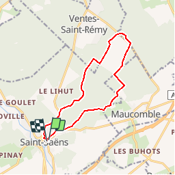
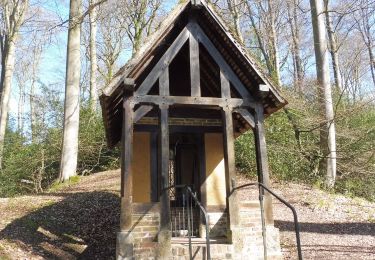
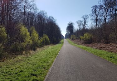
Trail Walking of 11.9 km to be discovered at Normandy, Seine-Maritime, Saint-Saëns. This trail is proposed by philippe76.
Description
Départ à St Saëns place de l'église (place Maintenon) puis prendre la rue Paul Lesueur. AD rue Ernest Leroy, AG D929, AG Chemin de la Garennerie. TD et AG rte ftière de la Verrerie. AG rte ftière des Limousins, AD rte ftière de la Commission, 1ère AG.
Option : Faire le tour du Camp Souverin par le chemin des écoliers.
Prendre AD et AG la rte ftière du Grimplet; AG la D12 jusqu'à la Place de départ.
Positioning
Comments
Trails nearby
![Trail Walking Ventes-Saint-Rémy - Forêt d'Eawy rando douce - Photo](https://media.geolcdn.com/t/375/260/46ed799a-be1a-46c2-a0e8-32b921a7c1f2.jpg&format=jpg&maxdim=2)
![Walking Walking](https://static1.geolcdn.com/sitytour/trail-icons/101.png)
Walking
![](/images/other/stat-length.png)
![](https://static1.geolcdn.com/siteimages/upload/files/16400158638029165_repeat_loop_refresh_sync_direction_icon.png)
![Trail Walking Bellencombre - Bellencombre forêt d'eawy - Photo](https://media.geolcdn.com/t/375/260/cf23086c-d9bc-431f-a5df-2c3b0d1e4fb1.jpg&format=jpg&maxdim=2)
![Walking Walking](https://static1.geolcdn.com/sitytour/trail-icons/101.png)
Walking
![](/images/other/stat-length.png)
![](https://static1.geolcdn.com/siteimages/upload/files/16400158638029165_repeat_loop_refresh_sync_direction_icon.png)
![Trail Walking Ventes-Saint-Rémy - Ventes St Remy 76 - Photo](https://media.geolcdn.com/t/375/260/48ee858b-9520-454b-b6ed-e614f9b4caff.jpg&format=jpg&maxdim=2)
![Walking Walking](https://static1.geolcdn.com/sitytour/trail-icons/101.png)
Walking
![](/images/other/stat-length.png)
![](https://static1.geolcdn.com/siteimages/upload/files/16400158638029165_repeat_loop_refresh_sync_direction_icon.png)
![Walking Walking](https://static1.geolcdn.com/sitytour/trail-icons/101.png)
Walking
![](/images/other/stat-length.png)
![](https://static1.geolcdn.com/siteimages/upload/files/16400158638029165_repeat_loop_refresh_sync_direction_icon.png)
![Trail Walking Saint-Saëns - 20190404 st saens - Photo](https://media.geolcdn.com/t/375/260/9151aba8-5cfd-4af0-b66f-cbd6d119bb92.jpg&format=jpg&maxdim=2)
![Walking Walking](https://static1.geolcdn.com/sitytour/trail-icons/101.png)
Walking
![](/images/other/stat-length.png)
![](https://static1.geolcdn.com/siteimages/upload/files/16400158638029165_repeat_loop_refresh_sync_direction_icon.png)
![Trail Walking Saint-Saëns - 20190404 st saens - Photo](https://media.geolcdn.com/t/375/260/file:///storage/emulated/0/Android/data/com.geolives.apps.sitytrail.beta/files/ressources/captured_photos/20180706151129.jpg&format=jpg&maxdim=2)
![Walking Walking](https://static1.geolcdn.com/sitytour/trail-icons/101.png)
Walking
![](/images/other/stat-length.png)
![](https://static1.geolcdn.com/siteimages/upload/files/16400158638029165_repeat_loop_refresh_sync_direction_icon.png)
![Trail Walking Saint-Saëns - 20160428-St Saens - Photo](https://media.geolcdn.com/t/375/260/ext.jpg?maxdim=2&url=https%3A%2F%2Fservices.sitytrail.com%2FGeolivesWS%2FDownloadMedia.ashx%3FTrailID%3D560247%26Media%3Dd971c4ae-ceef-469f-a1b9-979b7cf70306.JPG)
![Walking Walking](https://static1.geolcdn.com/sitytour/trail-icons/101.png)
Walking
![](/images/other/stat-length.png)
![](https://static1.geolcdn.com/siteimages/upload/files/16400158638029165_repeat_loop_refresh_sync_direction_icon.png)